

Landscape photography Helper
永晓 邵 Photo & Video iPhoneiPadiPod touch
Landscape photography Helper is a free Photo & Video app for iPhone and iPad by 永晓 邵. Rated 4.7/5 from 40 ratings. Requires iOS 16.0.
- Rating
- 4.7
- 40 ratings
- Price
- Free
- on the App Store
- Size
- 65 MB
- Age 4+
- Updated
- Oct 20
- 2026 · v10.0.4
Screenshots

About Landscape photography Helper
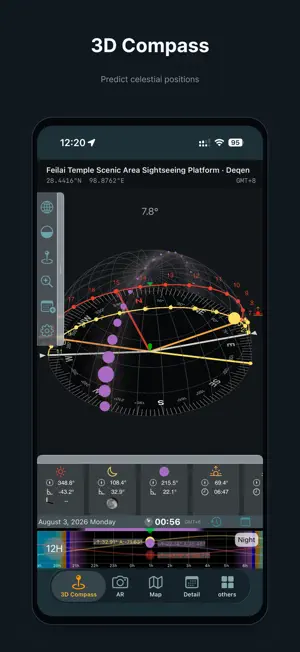
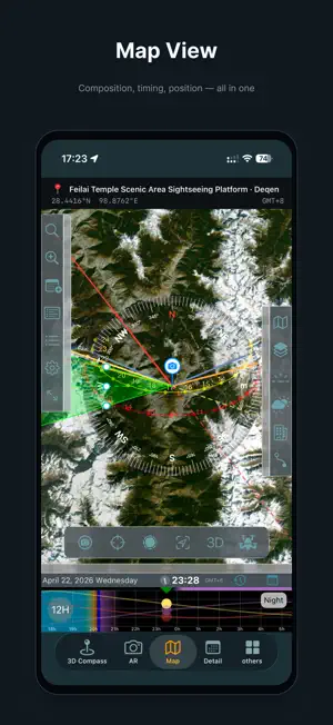
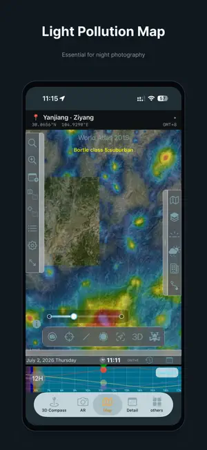
Behind every memorable landscape photograph lies the perfect alignment of time, light, and celestial motion. The real challenge is rarely pressing the shutter—it’s being in the right place, at the right time, facing the right direction. Landscape Photography Helper helps you understand and anticipate these natural rhythms. It is a photography planning tool that lets you evaluate light and celestial conditions before heading out, so every shoot begins with clarity rather than guesswork. In the free version, you get a complete set of core tools for understanding daily light changes and celestial movement. Use the timeline to preview the positions of the sun, moon, and Milky Way throughout the day. The 3D compass visualizes their direction and altitude in space, making light behavior intuitive instead of abstract data. With AR mode, you can preview the future positions of celestial objects directly in your real environment and see how they align with terrain and surroundings. The app also shows key astronomical events such as sunrise, sunset, golden hour, blue hour, and twilight, and allows you to add important moments to your system calendar for reminders. These features help you judge light and timing more confidently and make your shooting process more intentional. For photographers who need deeper planning and higher precision, Pro features are available via subscription. With Pro, you unlock the unlimited timeline to predict celestial positions at any date and time. You also gain access to advanced tools including star trail simulation, virtual viewfinder preview, sun and moon search, mountain identification, and comet position prediction. Pro also unlocks full map planning, allowing you to predict conditions at any location, view light pollution and weather data, and save shooting locations. Pro also includes a professional-grade 3D VR terrain prediction system. Built on real elevation data and independent of on-site sensors, it delivers stable predictions anywhere. You can simulate terrain occlusion, celestial paths, and real camera fields of view before arriving on location. Drone composition simulation is also supported within the same real 3D terrain environment. You can simulate drone flight altitude and lens perspective before takeoff to verify whether an aerial composition works. The system displays real AGL (Above Ground Level) altitude and horizontal distance to your composition point, helping you evaluate height constraints and flight feasibility. This feature assists with composition planning only and does not determine airspace legality. An integrated drone database includes common consumer models and camera parameters to better reflect real-world equipment performance. The latest version introduces building alignment planning. Built-in architectural models can be placed anywhere on the map, scaled to real dimensions, and rotated to match their orientation. You can plan precise alignments between celestial objects and buildings directly in VR and drone simulation scenes. Custom .obj models can also be imported, allowing you to add your own landmarks for personalized alignment planning. Landscape Photography Helper is not just a tool for viewing information—it is a tool for making decisions. It helps you feel confident before shooting, calm on location, and efficient in creation. Let great photographs be the result of preparation, not chance. Privacy Statement: https://www.landscapehelper.cn/privacy License Agreement: https://www.apple.com/legal/internet-services/itunes/dev/stdeula/
Ratings & reviews
4.7
40 ratings
What’s new
Version 10.0.4 · Updated October 20, 2026
• Official building models now support heading adjustments. • Adjust any building model’s heading with 0.001° precision, or tap the angle to enter a value directly. • Fixed a position mismatch between ground-projection wireframes in the model placement editor and the main map.
App privacy
The developer, 永晓 邵, reported these privacy practices to Apple.
Data Linked to You
The following data, which may be collected and linked to your identity, may be used for the following purposes:
- Purchases: Purchase History
- Identifiers: Device ID
- Usage Data: Product Interaction
Used for: Analytics
Alternatives to Landscape photography Helper
Looking for apps like Landscape photography Helper? Here are 6 similar apps on the App Store. The highest rated is Planit Pro: Photo Planner (4.8/5), and 5 of the 6 are free to download.
-
 Solunar Calculator
4.7
-
 Planit Pro: Photo Planner
4.8
-
 SetMyCamera
4.4
-
 蚂蚁摄影-找机位拍照点打卡神器,相机使用摄影学习工具
2.0
-
 喔图 - Photo Live Streaming
4.6
-
 米拍摄影
4.6
| App | Rating | Price | Last updated | Compare |
|---|---|---|---|---|
| Landscape photography Helper | 4.7 / 5 (40 ratings) | Free | October 20, 2026 | |
| Solunar Calculator | 4.7 / 5 (67) | Free | Sep 16, 2026 | Compare |
| Planit Pro: Photo Planner | 4.8 / 5 (1,465) | 9.99 USD | Oct 9, 2026 | Compare |
| SetMyCamera | 4.4 / 5 (141) | Free | Oct 14, 2026 | Compare |
| 蚂蚁摄影-找机位拍照点打卡神器,相机使用摄影学习工具 | 2.0 / 5 (1) | Free | Nov 15, 2025 | Compare |
| 喔图 - Photo Live Streaming | 4.6 / 5 (11) | Free | Oct 20, 2026 | Compare |
| 米拍摄影 | 4.6 / 5 (14) | Free | Sep 15, 2026 | Compare |