

Fly Forecast
Chris Carcerano Travel iPhoneiPadiPod touch
Fly Forecast is a free Travel app for iPhone and iPad by Chris Carcerano. Requires iOS 17.0. Updated October 13, 2026.
- Price
- Free
- on the App Store
- Size
- 15 MB
- Age 4+
- Updated
- Oct 13
- 2026 · v2.4.0
Screenshots

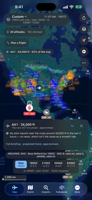

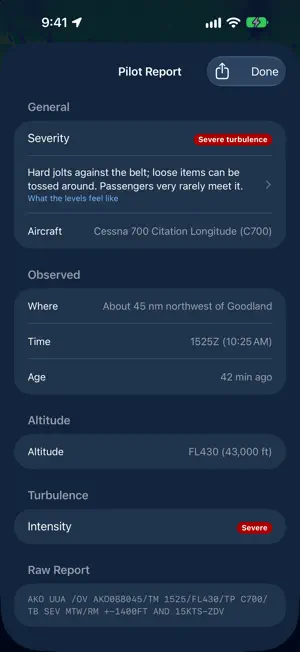
About Fly Forecast
See turbulence before you feel it. Fly Forecast puts the weather pilots fly by on one live map — real pilot reports of turbulence and icing, hazard areas, radar, satellite and official FAA charts — and briefs your flight: set a route and an altitude, and it tells you what the line flies through. For a pilot planning a leg, a frequent flyer picking the smoothest departure, or a nervous passenger wondering how tonight's flight will feel, Fly Forecast answers in plain words. BRIEF YOUR FLIGHT • Set a departure, destination, cruise altitude and time, and the route draws on the map • The briefing lists what lies along it: pilot reports near your altitude, the hazard areas the line crosses and whether they reach cruise, the freezing level, and the winds aloft as a headwind or tailwind • Takeoff and landing in plain words: gusts, crosswind, wind shear and storms • Compare Days: your route's turbulence and jet-stream forecast, eight days ahead • Check both ends against your personal minimums • Start a plan from a flight number, save plans by name, share any as a pilot's or passenger's PDF with map, terrain and NOTAMs, kept in Files LIVE TURBULENCE MAP • Pilot reports (PIREPs) in standard symbols, colored by severity, each with its altitude; tap one for the full report in plain words, aircraft type included • Presets for Turbulence, Icing, VFR Local, IFR Cruise and Convective • An altitude band and a time bar: hazards at your level, hours ahead or two days back • G-AIRMETs, SIGMETs, Center Weather Advisories, TFRs, the convective forecast, storm outlooks and watches, volcanic ash and fronts • A worldwide turbulence forecast, the jet stream, forecast gusts, station winds and the Atlantic tracks • Radar with echo tops and a loop, Canada's radar, satellite, and hurricanes with NHC cones and tracks • FAA VFR Sectional, IFR Low and IFR High charts underneath • Press and hold for a point briefing • Opens on saved data if you lose signal FOR PASSENGERS • Track a flight by number, today or a week ahead, with a reminder that morning, and see what lies along its route • Save the outlook before you board and read it in airplane mode • The Turbulence Meter measures the bumps you feel and keeps every flight, by the minute and on the map, to share or export • The Turbulence Guide explains what each level feels like and the sounds of a flight, with a breathing exercise A PREFLIGHT PAGE FOR EVERY AIRPORT • Almost 11,000 airports, with favorites, a home airport and the fields near you • Decoded METAR and TAF with flight categories, a six-hour trend and density altitude • Headwind and crosswind for every runway • Sunrise, sunset and twilight • NOTAMs, airport diagrams, FAA delays, the forecast discussion, and AWOS and ASOS with tap-to-call WINDS ALOFT & CHARTS • Winds and temperatures aloft for the US, Alaska, Hawaii and the Pacific, with each station's freezing level, or as barbs on the map • 1,900 charts: Graphical Forecasts for Aviation, the jet stream, turbulence (GTG) and icing (CIP/FIP) guidance, significant weather, GOES satellite and space weather MADE FOR THE COCKPIT • iCloud keeps your plans, meter sessions, favorites and settings the same on all your devices • Zulu time and a navy dark mode • VoiceOver for every marker on the map, and text that grows with your settings • Siri, Shortcuts, Spotlight airport search, and side panels on iPad • No sign-up, no ads, no tracking Data from the NOAA Aviation Weather Center, National Weather Service, Weather, Storm and Space Weather Prediction Centers, National Hurricane Center, the FAA, the USGS and NESDIS/STAR satellites, with international imagery from EUMETSAT, the German Weather Service (DWD) and the Japan Meteorological Agency, forecast winds from Environment and Climate Change Canada, flight positions from the adsb.lol and adsb.fi community networks and routes from adsbdb and adsb.im. Fly Forecast is an informational tool and not a substitute for an official preflight weather briefing.
What’s new
Version 2.4.0 · Updated October 13, 2026
Fly Forecast 2.4 keeps your flight plans and Turbulence Meter sessions, and carries them to all your devices with iCloud. SAVED FLIGHT PLANS • Save a plan by name from Plan a Flight, then update, rename or delete it • Start a plan from a flight number: it fills in the airports • Flight Plans, under More: edit, brief or send a plan to the map; share a pilot's or passenger's PDF, kept in Files • The pilot's PDF has a navigation log, fuel, NOTAMs, and the terrain and obstacles under the route in profile • Your favorite routes from 2.3 are already there as saved plans TURBULENCE METER SESSIONS • Every finished session is kept: summary, peak, time in each level and each minute's hardest bump • With a GPS fix, a session keeps its path: see it and its bumps on the map (Settings can turn this off) • Share, export (CSV) or delete sessions under More • Real bumps now count even while the phone is in your hand ICLOUD • Saved plans, meter sessions, favorites, home airport, units and minimums stay the same on every device signed in to iCloud • On by default; turn it off in Settings → iCloud FOR YOUR FLIGHT • Takeoff and landing in plain words: gusts, crosswind, wind shear and storms at each end of a planned flight • A reminder on the morning of a flight you looked up ahead • The turbulence forecast along your route, and Compare Days: the same flight on each of the next eight days • The briefing adds the route on a map, arrival with the wind, when to expect bumps, other levels, delays and daylight; saved briefings are in Plan a Flight • Look back: step the map through the last two days of reports and advisories • Forecast Check: today's turbulence forecast against what pilots report • Forecast Changes: what the newest forecast changed from the one before • The North Atlantic tracks, on the map CANADA AND ALASKA • Canada is its own map region, with its radar and a finer gust forecast • Alaska's turbulence and icing forecast charts, from Anchorage's forecasters TURBULENCE GUIDE • Four new topics: the sounds of a flight, the wing's moving parts, how crews avoid thunderstorms, and how turbulence forecasts are made NEW MAP LAYERS • A worldwide turbulence forecast at your flight level, the one airlines plan with • The jet stream: forecast wind near cruise, shaded where strong, worldwide • Surface wind: a barb at every reporting station, and a worldwide gust forecast • Storm outlook: the Storm Prediction Center's risk areas for the days ahead • Tornado and severe thunderstorm watches in effect ON THE MAP • The map shows at once at launch, and its markers fill in • All Regions: the world's reports and advisories on one map • Radar, satellite and jet stream opacity are yours to set; ash clouds are marked at every zoom • Major airports by code (ICAO for pilots, IATA for passengers); tap one for its preflight page • Share a pilot report or an airport from its details • Clearer hurricane cones, and each storm's sustained wind • Choosing a preset no longer changes your altitude band • A report's flight opens in the Flightradar24 app when it's installed CHARTS • Chart times in Zulu and local time • Jet-stream charts: observed winds at cruise over the US, and forecasts to 36 hours • Clear-air and mountain-wave turbulence charts, at fourteen levels up to 48,000 ft • Six more world areas of high-altitude significant weather and winds, and the mid-level North Atlantic chart ON IPAD • A wider details panel; the map moves so the marker you tapped stays in view • Tap the map to close a panel; Back from a page in a panel returns to it ALSO • Winds Aloft: every level in one table • A navy dark mode • Pilot or passenger sets your units: knots and °C, or mph, km/h and °F • The red Night appearance is gone; devices that used it switch to Dark • Fixed: a crash at launch on a Mac, hurricane cones missing until the map moved, and Active Tropical Storms opening two pages at once Questions or ideas? Email [email protected]. We read everything.
App privacy
The developer, Chris Carcerano, reported these privacy practices to Apple.
Data Not Collected
The developer does not collect any data from this app.
Alternatives to Fly Forecast
Looking for apps like Fly Forecast? Here are 6 similar apps on the App Store. The highest rated is Sky Guru: Fear of Flying Help (5.0/5), and all 6 are free to download.
-
 Flight Buddy: Calm Flying
4.6
-
 Flying Calmly
4.8
-
 Sky Guru: Fear of Flying Help
5.0
-
 Turby - Turbulence Forecasts
4.8
-
 Flight Anxiety - FlyCalm.me
4.3
-
 Airtura - Flight Guide
4.9
| App | Rating | Price | Last updated | Compare |
|---|---|---|---|---|
| Fly Forecast | – | Free | October 13, 2026 | |
| Flight Buddy: Calm Flying | 4.6 / 5 (123) | Free | Sep 25, 2026 | Compare |
| Flying Calmly | 4.8 / 5 (818) | Free | Sep 11, 2026 | Compare |
| Sky Guru: Fear of Flying Help | 5.0 / 5 (9) | Free | Oct 10, 2026 | Compare |
| Turby - Turbulence Forecasts | 4.8 / 5 (9) | Free | Aug 3, 2026 | Compare |
| Flight Anxiety - FlyCalm.me | 4.3 / 5 (55) | Free | Apr 1, 2024 | Compare |
| Airtura - Flight Guide | 4.9 / 5 (18) | Free | Oct 2, 2026 | Compare |
Compare Fly Forecast with the top alternatives: ratings, updates, ASO score and keyword gaps →