

Rock Mapper
Stefan Vollgger Productivity iPad
Rock Mapper is a free Productivity app for iPad by Stefan Vollgger. Rated 5.0/5 from 1 ratings. Requires iOS 26.0. Updated June 30, 2026.
- Rating
- 5.0
- 1 ratings
- Price
- Free
- on the App Store
- Size
- 88 MB
- Age 4+
- Updated
- Jun 30
- 2026 · v3.5.2
Screenshots

About Rock Mapper
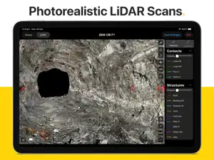
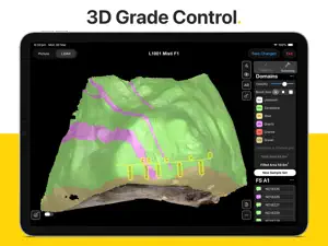
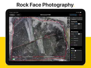
Rock Mapper is packed with powerful features: - 3D LIDAR SCANNING*: Generate photorealistic 3D models of rock faces & drives directly in the field using an iPad Pro. - AUGMENTED REALITY*: Share & re-visit photorealistic LiDAR scans in Augmented Reality on any modern iOS device. - PHOTOGRAPHY*: Take rock face photographs with the iPad's built-in camera. Rock Mapper takes care of all settings. - GEOREFERENCING*: Register rock face photographs and 3D LiDAR scans using survey points or drive direction laser stations. - MAPPING*: Directly map onto rock face photographs & 3D LiDAR scans using fully customisable annotation layers. - GRADE CONTROL*: Record face samples & sampling domains by directly drawing onto the rock face photograph or 3D LiDAR scan. - ROCK MASS ASSESSMENT*: Access dedicated tools for Q System (after Barton et al 1974) and RMR (after Bieniawski 1989). - REPORTING*: Auto-generated mapping reports, geotechnical reports & sampling reports saved as PDFs & ready to share. - CLOUD SYNC*: All data immediately available in ready-to-use formats on the Rock Mapper Cloud. - COMPATIBILITY: All data supplied in open, industry-standard formats that seamlessly integrate with 3D modelling platforms and database solutions, including Vulcan, Micromine, Leapfrog, Deswik, Surpac, Datamine, acQuire and MAXGEO datashed. *Only available with subscription Our clients around the globe love the data consistency, data fidelity, ease of use and time savings enabled by Rock Mapper. Lift your geological/geotechnical mapping & grade control workflow to a whole new level. Become a Rock Mapper today.
What’s new
Version 3.5.2 · Updated June 30, 2026
- New 'straighten' feature for linear sample sets on LiDAR scans - New 'resize linear sample set interval' option by long-pressing start / end of interval - FaceID now included in metadata CSV file and history CSV file - Sampling Author now included in collar CSV file of linear sample sets - Survey Point & Laser Station input form improvements - JPG size optimisation for all photographs (reduced file sizes without any visible changes in image quality) - New [FaceID]_error.log file to assist with troubleshooting - Simplify / downsample polylines. All mapping lines now have a lower number of nodes, which can be further reduced by enabling Simplify Lines in Settings > General > Mapping Annotations. - LiDAR scanning now supports any device orientation
App privacy
The developer, Stefan Vollgger, reported these privacy practices to Apple.
Data Not Collected
The developer does not collect any data from this app.
Alternatives to Rock Mapper
Looking for apps like Rock Mapper? Here are 6 similar apps on the App Store.
-
 Datamine Discover Mobile
-
 Deswik.SmartMap
-
 Deswik.Drilling
-
 Pitram Connect
-
 Deswik.Survey
-
 acQuire Arena 5.4
| App | Rating | Price | Last updated | Compare |
|---|---|---|---|---|
| Rock Mapper | 5.0 / 5 (1 rating) | Free | June 30, 2026 | |
| Datamine Discover Mobile | – | Free | Aug 11, 2026 | Compare |
| Deswik.SmartMap | – | Free | Jul 29, 2026 | Compare |
| Deswik.Drilling | – | Free | Jul 29, 2026 | Compare |
| Pitram Connect | – | Free | Jul 24, 2026 | Compare |
| Deswik.Survey | – | Free | Jul 30, 2026 | Compare |
| acQuire Arena 5.4 | – | Free | Apr 16, 2025 | Compare |
Compare Rock Mapper with the top alternatives: ratings, updates, ASO score and keyword gaps →