
About FireRanger
FireRanger -- An Intelligent Wildfire Management System
FireRanger is an application for fire rangers and forest rangers designed to enhance the real-time monitoring, reporting, and response to wildfire events.
--- Key Features ---
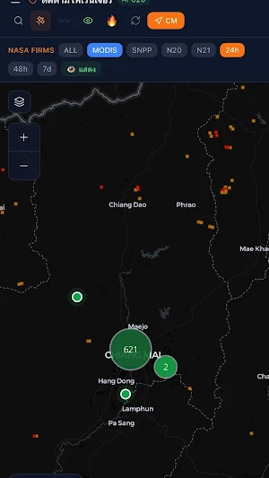
Real-time Map
View the location of all fire rangers on a live map, with hotspot data from NASA FIRMS (MODIS, VIIRS-SNPP, NOAA-20, NOAA-21) for 24-hour, 48-hour, and 7-day periods.
Automatic GPS Tracking
The GPS system runs in the background, automatically sending fire ranger locations every 30 seconds when deployed. Supports offline operation and data synchronization when a signal is available.
Fire Incident Reporting
Instantly report fire incidents with automatic GPS coordinates, severity level, description, and photos.
Navigation Routes
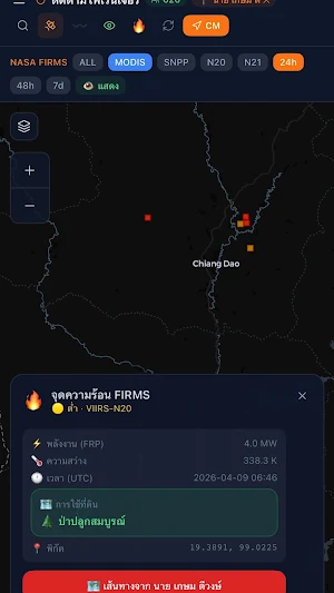
Calculate routes from a fire ranger's location to a hotspot or event, including estimated distance and time.
NASA FIRMS Hotspot Data
Tap on a hotspot to view detailed information, including fire energy rating (FRP), brightness, temperature, time of detection, and land use type.
--- Management System ---
Overview of all Fire Rangers
Displays all fire rangers on a map with automatic clustering based on status.
Manages registration requests.
Approve or reject system participation requests and automatically generate temporary passwords.
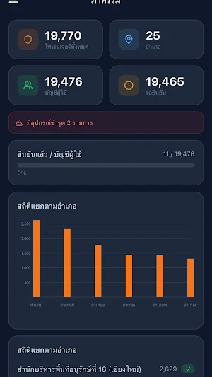
Statistics dashboard.
View the number of fire rangers by district, registration status, and operational statistics in graph format.
--- Suitable for ---
- Fire rangers and field personnel
- Executives and central staff, Regional Conservation Area Administration 16 (Chiang Mai)
- Agencies responsible for wildfire management in Northern Thailand
Requires an account approved by the administrator.
Similar Apps
FireD
The application supports the management of biomass fuels by fire or open burning.
Smart NPK
Soil quality application to provide soil information to support Thailand farmer
AirVista
แอพพลิเคชันพยากรณ์คุณภาพอากาศสำหรับภาคเหนือ ประเทศไทย และพื้นที่ข้างเคียง
