

FindTheWay: Offline Navigation
zemlin Maps & Navigation
Offline hiking maps, GPX routing, elevation profiles & Wear OS support.
- Downloads
- 10+
- on Google Play
- Price
- Free
- No in-app purchases
- Updated
- Sep 22
- 2026
Screenshots



About FindTheWay: Offline Navigation
FindTheWay: Offline Navigation & Maps
Navigate with confidence across Europe with high-performance offline maps. FindTheWay is a lightweight, clean navigation app for hikers, cyclists, and outdoor explorers who value simplicity, performance, and privacy.
📱 Clean Full-Screen Map UI
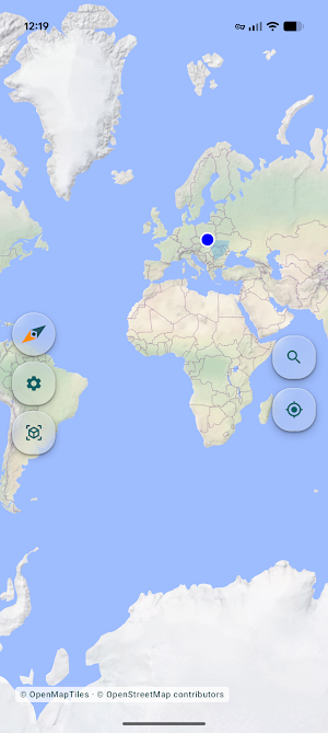
A distraction-free, full-screen map on a modern Material 3 interface with glassmorphism elements — no ads, no banners, no cluttered overlays.
⌚ Wear OS Companion App
Leave your phone in your pocket and navigate from your wrist:
• View offline vector maps directly on your Wear OS watch.
• Send GPX tracks and offline map areas from your phone to the watch.
• Track your position with the watch's own GPS.
The watch app is a companion to the phone app: maps and tracks are prepared on the phone, so install both.
Key Features:
🌍 Fast Offline Vector Maps
Carry European regions in your pocket. Vector maps (OpenStreetMap data) are far smaller and faster than raster maps, with smooth browsing and 3D support even in remote areas.
🔍 Place Search, Offline or Online
Find towns, peaks, and points of interest inside your downloaded areas with no connection at all. Online search is available for wider coverage when you have a signal.
🛤️ GPX Trails: Import, Create & Export
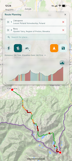
Import GPX tracks to follow them, or plan and draw your own route on the map. Export planned tracks to GPX to share them or load them onto sport watches. Stay on course with real-time distance tracking, elevation profiles, and smart off-route alerts.
🧭 Route Planning for Walking, Hiking, Cycling and Driving
Routes are calculated on your device from downloaded routing data, with no connection required. If that data is missing for the area you picked, the app asks your permission before calculating the route online.
⛰️ Elevation Profiles & Contour Lines
Check total elevation gain and loss before you set out, and read the terrain from detailed contour lines rendered on the map.
📍 Saved Locations & Beeline Navigation
Save your car, campsite, or a favourite viewpoint, and get a straight-line bearing back to it — invaluable when you lose the path in dense forest.
🔋 Optimized for the Outdoors
A Battery Saver mode (60 Hz screen refresh rate), a "Screen always on" toggle, and an OLED-optimised dark mode keep your phone alive through a full day on the trail.
🛡️ Privacy by Design
No account, no registration, no ads, no trackers, no analytics. Once your data is downloaded, maps, search, route planning and navigation all run on your device, and your position is processed there.
Online features are optional: online place search, online route calculation and online map tiles connect to third-party providers, and sending your coordinates always asks for your consent first — which you can withdraw at any time in Settings. Feedback and bug reports are sent only when you send them. The privacy policy lists every service involved.
Why Choose FindTheWay?
• Offline reliable: no signal needed inside downloaded map areas.
• Clean screen: no ads, no banners, no pop-ups — just you and the trail.
• Privacy-first: no accounts, no trackers, no advertising, and every online feature is one you opt into.
💬 Support & Feedback
Found a bug or have an idea? The settings contain a feedback form — send suggestions or reports, with optional diagnostic logs, straight from the app.
Download FindTheWay today and explore the outdoors with complete peace of mind!
*** LEGAL DISCLAIMER / TERMS OF USE ***
This application is developed by an individual developer and is provided for informational and recreational purposes only. It is not certified safety or navigation software. Data and services are provided on an "as-is" basis. The developer is not responsible for any inaccuracies or any damages, injuries, or safety incidents resulting from the use of this app. Use entirely at your own risk. Users are responsible for navigating safely, interpreting terrain conditions, and carrying a traditional physical map and compass.
Navigate with confidence across Europe with high-performance offline maps. FindTheWay is a lightweight, clean navigation app for hikers, cyclists, and outdoor explorers who value simplicity, performance, and privacy.
📱 Clean Full-Screen Map UI
A distraction-free, full-screen map on a modern Material 3 interface with glassmorphism elements — no ads, no banners, no cluttered overlays.
⌚ Wear OS Companion App
Leave your phone in your pocket and navigate from your wrist:
• View offline vector maps directly on your Wear OS watch.
• Send GPX tracks and offline map areas from your phone to the watch.
• Track your position with the watch's own GPS.
The watch app is a companion to the phone app: maps and tracks are prepared on the phone, so install both.
Key Features:
🌍 Fast Offline Vector Maps
Carry European regions in your pocket. Vector maps (OpenStreetMap data) are far smaller and faster than raster maps, with smooth browsing and 3D support even in remote areas.
🔍 Place Search, Offline or Online
Find towns, peaks, and points of interest inside your downloaded areas with no connection at all. Online search is available for wider coverage when you have a signal.
🛤️ GPX Trails: Import, Create & Export
Import GPX tracks to follow them, or plan and draw your own route on the map. Export planned tracks to GPX to share them or load them onto sport watches. Stay on course with real-time distance tracking, elevation profiles, and smart off-route alerts.
🧭 Route Planning for Walking, Hiking, Cycling and Driving
Routes are calculated on your device from downloaded routing data, with no connection required. If that data is missing for the area you picked, the app asks your permission before calculating the route online.
⛰️ Elevation Profiles & Contour Lines
Check total elevation gain and loss before you set out, and read the terrain from detailed contour lines rendered on the map.
📍 Saved Locations & Beeline Navigation
Save your car, campsite, or a favourite viewpoint, and get a straight-line bearing back to it — invaluable when you lose the path in dense forest.
🔋 Optimized for the Outdoors
A Battery Saver mode (60 Hz screen refresh rate), a "Screen always on" toggle, and an OLED-optimised dark mode keep your phone alive through a full day on the trail.
🛡️ Privacy by Design
No account, no registration, no ads, no trackers, no analytics. Once your data is downloaded, maps, search, route planning and navigation all run on your device, and your position is processed there.
Online features are optional: online place search, online route calculation and online map tiles connect to third-party providers, and sending your coordinates always asks for your consent first — which you can withdraw at any time in Settings. Feedback and bug reports are sent only when you send them. The privacy policy lists every service involved.
Why Choose FindTheWay?
• Offline reliable: no signal needed inside downloaded map areas.
• Clean screen: no ads, no banners, no pop-ups — just you and the trail.
• Privacy-first: no accounts, no trackers, no advertising, and every online feature is one you opt into.
💬 Support & Feedback
Found a bug or have an idea? The settings contain a feedback form — send suggestions or reports, with optional diagnostic logs, straight from the app.
Download FindTheWay today and explore the outdoors with complete peace of mind!
*** LEGAL DISCLAIMER / TERMS OF USE ***
This application is developed by an individual developer and is provided for informational and recreational purposes only. It is not certified safety or navigation software. Data and services are provided on an "as-is" basis. The developer is not responsible for any inaccuracies or any damages, injuries, or safety incidents resulting from the use of this app. Use entirely at your own risk. Users are responsible for navigating safely, interpreting terrain conditions, and carrying a traditional physical map and compass.
What’s new
Updated September 22, 2026
Fixed a crash that could occur on Android 10 and earlier supported versions when location was turned off or on while using the map.
User reviews

This app is an absolute game-changer for hitting the trails. I was especially impressed by the offline mode, it kept me exactly on the right path even deep in the mountains where there was absolutely no cell service. The interface is clean, and the ability to plan out a route based on elevation gain is a brilliant f...

Awesome app! Everything works really fast, and the interface is clean and functional. Plus, it's completely free and ad-free.
Alternatives to FindTheWay: Offline Navigation
Looking for apps like FindTheWay: Offline Navigation? Here are 6 similar Android apps on Google Play. The highest rated is GPX Viewer PRO: Hike & Bike (4.6/5), and 5 of the 6 are free to download.
-
TrailLink: Bike, Run, Walk 4.1
-
BaseMap: 3D Hunting Maps & GPS 4.0
-
Tripomatic Planner & Maps 4.2
-
GPX Viewer PRO: Hike & Bike 4.6
-
Hikingbook: Hike, Bike & Run 3.8
-
FarOut 4.5
| App | Rating | Price | Installs | Last updated |
|---|---|---|---|---|
| FindTheWay: Offline Navigation | – | Free | 10+ | Sep 22, 2026 |
| TrailLink: Bike, Run, Walk | 4.1 / 5 | Free | 100,000+ | – |
| BaseMap: 3D Hunting Maps & GPS | 4.0 / 5 | Free | 100,000+ | – |
| Tripomatic Planner & Maps | 4.2 / 5 | Free | 1,000,000+ | – |
| GPX Viewer PRO: Hike & Bike | 4.6 / 5 | 8.99 USD | 100,000+ | Sep 21, 2026 |
| Hikingbook: Hike, Bike & Run | 3.8 / 5 | Free | 10,000+ | – |
| FarOut | 4.5 / 5 | Free | 50,000+ | – |