
땅울림 : 실시간 지진 전세계 규모 진도 조회
%EB%84%A4%EB%AA%A8%ED%8C%A9%ED%86%A0%EB%A6%AC Weather Contains ads
265 observation stations nationwide and recent earthquakes on a single map. We look at major earthquakes in Korea since 1978 as well as today's global earthquakes.
- Downloads
- 1+
- on Google Play
- Price
- Free
- No in-app purchases
- Updated
- Oct 25
- 2026 · v1.1.0
Screenshots
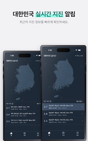


About 땅울림 : 실시간 지진 전세계 규모 진도 조회
This is not an app you turn on only when an earthquake occurs.
It is also a map that shows that the entire country is quiet today.
■ Korean Peninsula Real-time Map
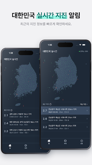
265 earthquake observation stations across the country are marked as dots on the map. It appears green when it is quiet, and the color changes when it shakes. When an earthquake occurs, ripples spread from the spot.
■ Recent Earthquake List
Listed in chronological order, starting with the most recent earthquake. It records the magnitude, the time elapsed, the depth, and the maximum intensity.
Press the exclamation mark next to the intensity to view the shaking intensity levels from I to XII,
exactly according to the Korea Meteorological Administration standards.
■ Past Earthquakes
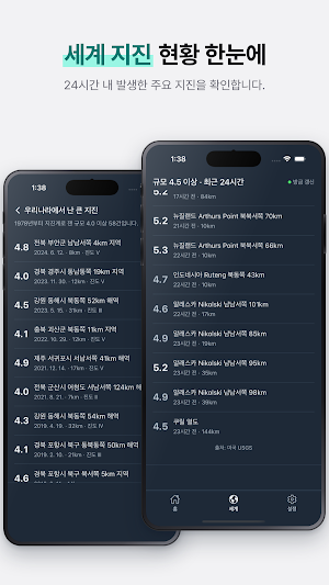
We have collected major earthquakes that occurred in Korea since 1978 with a magnitude of 4.0 or higher, measured by seismographs.
Here you can find the locations and magnitudes of Gyeongju in 2016 and Pohang in 2017.
■ World Earthquakes
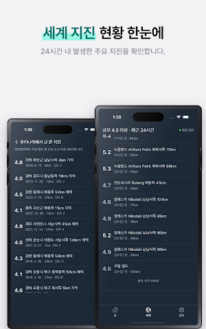
Magnitude 4.5 or higher, within the last 24 hours. Place names are written in Hangul starting with the country name,
making the list easier to read.
■ Data
Data is received from the Korea Meteorological Administration for domestic use and the U.S. Geological Survey (USGS) for global use.
Since we do not maintain a separate server, we display the received data exactly as is.
■ What this app does not do — Earthquake notifications
Jang-eullim does not send push notifications.
The fastest way to receive an earthquake notification is through emergency disaster text messages sent by the government,
and you receive these even without installing the app. Do not use this app to wait for notifications.
Jang-eullim takes on the role of providing information next in line.
Information on where and how much the ground shook, and what events occurred on this land in the past.
It is also a map that shows that the entire country is quiet today.
■ Korean Peninsula Real-time Map
265 earthquake observation stations across the country are marked as dots on the map. It appears green when it is quiet, and the color changes when it shakes. When an earthquake occurs, ripples spread from the spot.
■ Recent Earthquake List
Listed in chronological order, starting with the most recent earthquake. It records the magnitude, the time elapsed, the depth, and the maximum intensity.
Press the exclamation mark next to the intensity to view the shaking intensity levels from I to XII,
exactly according to the Korea Meteorological Administration standards.
■ Past Earthquakes
We have collected major earthquakes that occurred in Korea since 1978 with a magnitude of 4.0 or higher, measured by seismographs.
Here you can find the locations and magnitudes of Gyeongju in 2016 and Pohang in 2017.
■ World Earthquakes
Magnitude 4.5 or higher, within the last 24 hours. Place names are written in Hangul starting with the country name,
making the list easier to read.
■ Data
Data is received from the Korea Meteorological Administration for domestic use and the U.S. Geological Survey (USGS) for global use.
Since we do not maintain a separate server, we display the received data exactly as is.
■ What this app does not do — Earthquake notifications
Jang-eullim does not send push notifications.
The fastest way to receive an earthquake notification is through emergency disaster text messages sent by the government,
and you receive these even without installing the app. Do not use this app to wait for notifications.
Jang-eullim takes on the role of providing information next in line.
Information on where and how much the ground shook, and what events occurred on this land in the past.
What’s new
Version 1.1.0 · Updated October 25, 2026
사소한 버그 패치
Alternatives to 땅울림 : 실시간 지진 전세계 규모 진도 조회
Looking for apps like 땅울림 : 실시간 지진 전세계 규모 진도 조회? Here are 6 similar Android apps on Google Play. All of them are free to download.
-
낚시가자 : 물때 낚시금지구역 낚금 바다낚시 해루질
-
GoHike: Korea Mountain Guide
-
Griddy: Day Planner·Todo·Habit
-
GoValley: Korea Water Escapes
-
쓱쓱가계부 : 용돈기입장 생활비 지출관리 예산
-
싸게날자 - 해외여행 & 최저가항공권
| App | Rating | Price | Installs | Last updated | Compare |
|---|---|---|---|---|---|
| 땅울림 : 실시간 지진 전세계 규모 진도 조회 | – | Free | 1+ | Oct 25, 2026 | |
| 낚시가자 : 물때 낚시금지구역 낚금 바다낚시 해루질 | – | Free | 500+ | Oct 27, 2026 | Compare |
| GoHike: Korea Mountain Guide | – | Free | 1,000+ | Oct 25, 2026 | Compare |
| Griddy: Day Planner·Todo·Habit | – | Free | 10+ | – | Compare |
| GoValley: Korea Water Escapes | – | Free | 100+ | – | Compare |
| 쓱쓱가계부 : 용돈기입장 생활비 지출관리 예산 | – | Free | 100+ | Oct 25, 2026 | Compare |
| 싸게날자 - 해외여행 & 최저가항공권 | – | Free | 10+ | – | Compare |