
Sea Depth
SEADEPTH CHARTS Maps & Navigation In-app purchases
Offshore Bathymetry Charts
- Downloads
- 1.1K+
- on Google Play
- Price
- Free
- In-app purchases
- Updated
- Sep 28
- 2026 · v1.0.21
Screenshots

About Sea Depth
SeaDepth delivers professional-grade bathymetric charts for anglers looking to add a new level of detail and insight offshore.
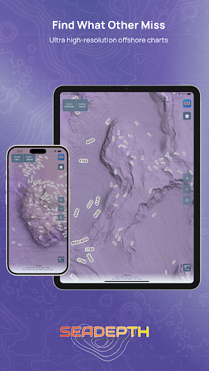
Built using high-resolution survey data and advanced shaded-relief techniques, SeaDepth reveals underwater structure, contours, and terrain that traditional charts often fail to show. The result is a clearer, more intuitive view of the seafloor—helping anglers and captains better understand offshore environments before and during time on the water.
In addition to detailed depth visualization, SeaDepth offers optional data overlays, intelligent contour labeling, waypoint interoperability, and analytical tools that enhance situational awareness offshore.
Key Features
• High-resolution shaded-relief bathymetry
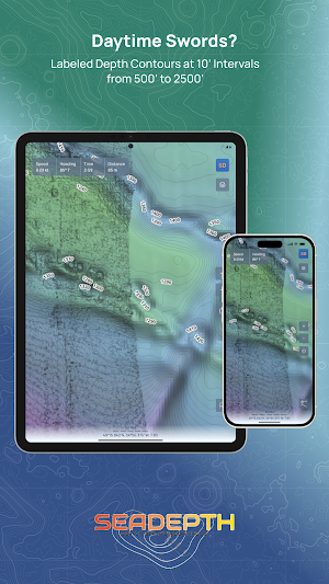
• Detailed, clearly labeled depth contours
• Intelligent contour interval scaling by depth range
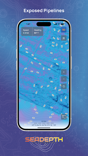
• Pipeline overlay (Gulf of America)
• Bottom composition overlays highlighting seafloor characteristics
• GPX waypoint import and export for interoperability with other platforms
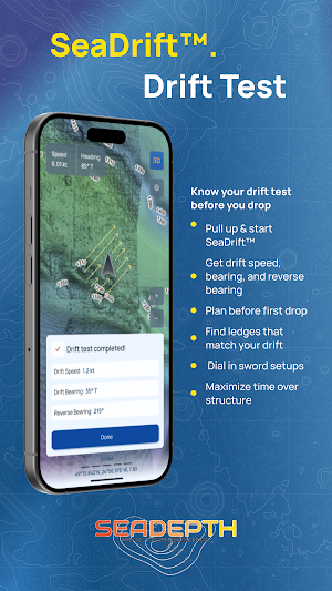
• Drift Test tool to observe drift direction and speed over time
• Offline chart access for use beyond cellular coverage
• Smooth zooming and panning optimized for offshore use
Depth Contours with Intelligent Labeling
SeaDepth uses a graduated contour labeling scheme designed to provide maximum detail where it matters most, while maintaining clarity and performance in deeper
depths:
• 1-foot contour intervals from 1 to 500 feet
• 10-foot contour intervals from 500 to 2,500 feet
• 80-foot contour intervals from 2,500 feet to abyssal depths
This approach delivers high-resolution insight in shallow and mid-depth areas while avoiding visual clutter in deepwater environments.
Overlay Intelligence
SeaDepth allows users to enable optional overlay layers such as pipelines and bottom composition data in supported regions, including the Gulf of America. These overlays provide additional context and help users interpret bottom features and structural edges with greater confidence. All available overlay layers are included at no additional charge.
Waypoint Management (GPX Support)
SeaDepth supports importing and exporting waypoints using the GPX file format, making it easy to move data between SeaDepth and other compatible marine devices, charting software, or planning tools. This allows users to maintain consistent waypoint libraries across platforms.
SeaDrift-Drift Test Feature
The built-in Drift Test feature helps users evaluate drift behavior by tracking movement over time. This is especially useful when assessing current and wind influence to have more productive drifts.
Built for Offshore Reliability
Charts, overlays, and waypoint data are stored locally on the device, allowing SeaDepth to function reliably offshore where connectivity may be limited or unavailable. Performance and usability are optimized for real-world offshore conditions.
Disclaimer
SeaDepth is intended as a supplemental planning and visualization tool only. It is not a substitute for official nautical charts, onboard navigation systems, or prudent seamanship.
Built using high-resolution survey data and advanced shaded-relief techniques, SeaDepth reveals underwater structure, contours, and terrain that traditional charts often fail to show. The result is a clearer, more intuitive view of the seafloor—helping anglers and captains better understand offshore environments before and during time on the water.
In addition to detailed depth visualization, SeaDepth offers optional data overlays, intelligent contour labeling, waypoint interoperability, and analytical tools that enhance situational awareness offshore.
Key Features
• High-resolution shaded-relief bathymetry
• Detailed, clearly labeled depth contours
• Intelligent contour interval scaling by depth range
• Pipeline overlay (Gulf of America)
• Bottom composition overlays highlighting seafloor characteristics
• GPX waypoint import and export for interoperability with other platforms
• Drift Test tool to observe drift direction and speed over time
• Offline chart access for use beyond cellular coverage
• Smooth zooming and panning optimized for offshore use
Depth Contours with Intelligent Labeling
SeaDepth uses a graduated contour labeling scheme designed to provide maximum detail where it matters most, while maintaining clarity and performance in deeper
depths:
• 1-foot contour intervals from 1 to 500 feet
• 10-foot contour intervals from 500 to 2,500 feet
• 80-foot contour intervals from 2,500 feet to abyssal depths
This approach delivers high-resolution insight in shallow and mid-depth areas while avoiding visual clutter in deepwater environments.
Overlay Intelligence
SeaDepth allows users to enable optional overlay layers such as pipelines and bottom composition data in supported regions, including the Gulf of America. These overlays provide additional context and help users interpret bottom features and structural edges with greater confidence. All available overlay layers are included at no additional charge.
Waypoint Management (GPX Support)
SeaDepth supports importing and exporting waypoints using the GPX file format, making it easy to move data between SeaDepth and other compatible marine devices, charting software, or planning tools. This allows users to maintain consistent waypoint libraries across platforms.
SeaDrift-Drift Test Feature
The built-in Drift Test feature helps users evaluate drift behavior by tracking movement over time. This is especially useful when assessing current and wind influence to have more productive drifts.
Built for Offshore Reliability
Charts, overlays, and waypoint data are stored locally on the device, allowing SeaDepth to function reliably offshore where connectivity may be limited or unavailable. Performance and usability are optimized for real-world offshore conditions.
Disclaimer
SeaDepth is intended as a supplemental planning and visualization tool only. It is not a substitute for official nautical charts, onboard navigation systems, or prudent seamanship.
What’s new
Version 1.0.21 · Updated September 28, 2026
New: Georgia-Carolina Coast chart • Over 40,000 square miles from Jacksonville, FL to Wilmington, NC • Includes Southport, Charleston, Savannah and Brunswick Bank Zoom charts • New free Mid-Atlantic Base Map. Choose the base map for your region: Gulf of America & Florida or Mid-Atlantic • Bug fixes and performance improvements
Alternatives to Sea Depth
Looking for apps like Sea Depth? Here are 6 similar Android apps on Google Play. All of them are free to download.




| App | Rating | Price | Installs | Last updated | Compare |
|---|---|---|---|---|---|
| Sea Depth | – | Free | 1,000+ | Sep 28, 2026 | |
| RidePak | – | Free | 500+ | – | Compare |
| MOBI App | – | Free | 10,000+ | Oct 14, 2026 | Compare |
| Source CY | – | Free | 1,000+ | Aug 31, 2026 | Compare |
| تاكسير - قارن اسعار التاكسي | – | Free | 10+ | Jul 23, 2026 | Compare |
| Apple 2 Waze Converter | – | Free | 1,000+ | Jul 6, 2026 | Compare |
| ShoreMeter | – | Free | 100+ | Aug 4, 2026 | Compare |
Compare Sea Depth with the top alternatives: ratings, updates, ASO score and keyword gaps →
Similar apps on Google Play
- RidePak
- MOBI App
- Source CY
- تاكسير - قارن اسعار التاكسي
- Apple 2 Waze Converter
- ShoreMeter
- Zyder: Cabs, Bike & Auto
- LifeHere
- 보카리! 최애가 해주는 길안내,내비
- Sevi: AI Travel Guide & Maps
- Execulyft Rider
- SafeCity Cameras Balkan
- Mobinex rastreamento veicular
- DEIXA QUE EU LEVO - Entregador
- GPS Satellite Live Earth Map
- Live Transit Bus & Metro
- SlickRide - Book Rides
- EV Repair Finder
- Cövek
- ParkingLight: Smart Car Finder
- Pursi - merikartat ja -tiedot
- BT GPS Provider & Track Logger
- LiveMap: GPS Map Camera Geotag
- RockHoundR: Rockhounding Map
- Fastloc Rastreamento