

GeoTransit
Óscar Stojanovic Travel & Local
GeoTransit shows upcoming public transportation departures in real time.
- Downloads
- 100+
- on Google Play
- Price
- Free
- No in-app purchases
- Updated
- Oct 31
- 2025
Screenshots


About GeoTransit
GeoTransit is an intuitive and easy-to-use application that allows you to get around Barcelona more efficiently using public transport. With an interactive, real-time map, GeoTransit provides you with detailed information about all means of public transportation in the city, including trains, subways, buses and trams. With features that enhance your daily experience, GeoTransit is the ideal tool for urban commuters.
Main features:
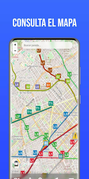
Interactive public transport map: Consult an updated map with all the stops and stations of the different means of transport in Barcelona. Easily navigate the lines and quickly locate your destination.
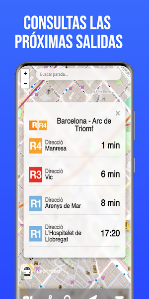
Real-time information: With GeoTransit you can see in real time when your train or subway will arrive. Check the arrival time of any means of transportation and you will never again have to wait without knowing when it will arrive.
Nearby location: With the "Location" function, you will be able to see the public transport stops closest to you. In addition, you will be able to know the exact distance to each stop, which makes your planning easier and saves time.
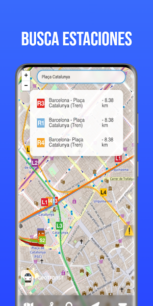
Stop search engine: GeoTransit includes a search engine where you can search for any public transport stop in Barcelona. When you perform the search, a list will appear with the stop, the line it belongs to, the means of transport (train, metro, bus, tram) and the exact distance it is located, all clearly and quickly.
Viewing transport lines: Access detailed information about each line by selecting the means of transport. The stops are shown in a clear and accessible way, represented in the form of a visual thermometer that allows you to quickly see the situation of each line.
Real-time alerts: Stay informed about any incident or alert that may affect your journey. GeoTransit notifies you about service interruptions, changes or delays so you can make more informed decisions about your route.
Favorite stops: Add the stops you visit most frequently to your favorites list and quickly check upcoming departures. This functionality helps you optimize your time, allowing you to access the updated status of your favorite routes in just one click.
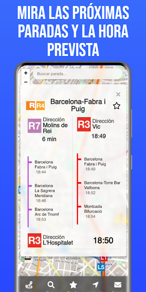
Display of upcoming stops in the form of a thermometer: At each stop, in addition to seeing the arrival of the train, metro or tram in real time, you can view the next stops and the approximate time of arrival at each one in the form of a thermometer. This innovative tool allows you to anticipate the development of your trip and optimally manage your time.
With GeoTransit, getting around Barcelona has never been easier. Whether you are at home, at work or anywhere in the city, GeoTransit helps you plan your trips and optimize your travel time. Download GeoTransit today and enjoy the best public transport experience in Barcelona!
Main features:
Interactive public transport map: Consult an updated map with all the stops and stations of the different means of transport in Barcelona. Easily navigate the lines and quickly locate your destination.
Real-time information: With GeoTransit you can see in real time when your train or subway will arrive. Check the arrival time of any means of transportation and you will never again have to wait without knowing when it will arrive.
Nearby location: With the "Location" function, you will be able to see the public transport stops closest to you. In addition, you will be able to know the exact distance to each stop, which makes your planning easier and saves time.
Stop search engine: GeoTransit includes a search engine where you can search for any public transport stop in Barcelona. When you perform the search, a list will appear with the stop, the line it belongs to, the means of transport (train, metro, bus, tram) and the exact distance it is located, all clearly and quickly.
Viewing transport lines: Access detailed information about each line by selecting the means of transport. The stops are shown in a clear and accessible way, represented in the form of a visual thermometer that allows you to quickly see the situation of each line.
Real-time alerts: Stay informed about any incident or alert that may affect your journey. GeoTransit notifies you about service interruptions, changes or delays so you can make more informed decisions about your route.
Favorite stops: Add the stops you visit most frequently to your favorites list and quickly check upcoming departures. This functionality helps you optimize your time, allowing you to access the updated status of your favorite routes in just one click.
Display of upcoming stops in the form of a thermometer: At each stop, in addition to seeing the arrival of the train, metro or tram in real time, you can view the next stops and the approximate time of arrival at each one in the form of a thermometer. This innovative tool allows you to anticipate the development of your trip and optimally manage your time.
With GeoTransit, getting around Barcelona has never been easier. Whether you are at home, at work or anywhere in the city, GeoTransit helps you plan your trips and optimize your travel time. Download GeoTransit today and enjoy the best public transport experience in Barcelona!
Alternatives to GeoTransit
Looking for apps like GeoTransit? Here are 6 similar Android apps on Google Play. The highest rated is Ferryhopper - The Ferries App (4.7/5), and 4 of the 6 are free to download.
-
YEGO Mobility 4.6
-
Südtirol Fishing
-
Volotea 2.8
-
Paris Metro – Map and Routes 4.4
-
Bike Route Planner
-
Ferryhopper - The Ferries App 4.7
| App | Rating | Price | Installs | Last updated | Compare |
|---|---|---|---|---|---|
| GeoTransit | – | Free | 100+ | Oct 31, 2025 | |
| YEGO Mobility | 4.6 / 5 | Free | 500,000+ | Aug 14, 2026 | Compare |
| Südtirol Fishing | – | – | 5,000+ | Sep 15, 2026 | Compare |
| Volotea | 2.8 / 5 | Free | 1,000,000+ | Oct 28, 2026 | Compare |
| Paris Metro – Map and Routes | 4.4 / 5 | Free | 1,000,000+ | Sep 10, 2026 | Compare |
| Bike Route Planner | – | – | – | Dec 15, 2025 | Compare |
| Ferryhopper - The Ferries App | 4.7 / 5 | Free | 1,000,000+ | Oct 27, 2026 | Compare |
Compare GeoTransit with the top alternatives: ratings, updates, ASO score and keyword gaps →