
Compass Camera Offline MGRS
Maps & Navigation In-app purchases
Live compass camera with MGRS, offline maps & photo logging for field use.
- Downloads
- 848+
- on Google Play
- Price
- Free
- In-app purchases
- Updated
- Aug 11
- 2026 · v1.4
Screenshots
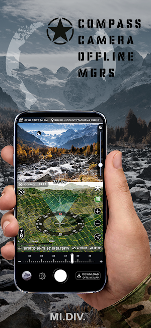
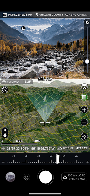
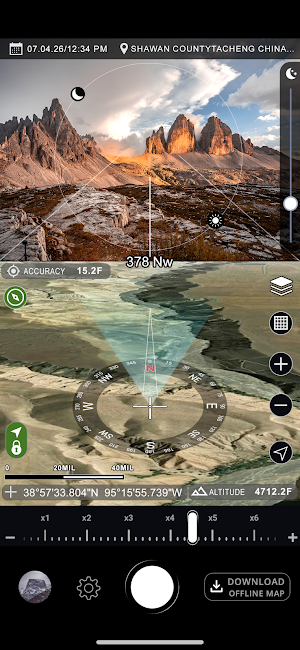


About Compass Camera Offline MGRS
MGRS Compass Camera & Offline Maps is a field navigation and photo app that combines a live compass camera, MGRS grid, offline satellite and topographic maps, and low-light visibility enhancement in one tool.
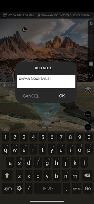
Use the camera to view direction, heading, and coordinate data directly on screen while comparing the scene with the map below. Download map areas by square tiles for offline use, save important locations, and capture photos with navigation data attached.
The app is built for outdoor navigation, terrain reference, travel, field documentation, and low-light scene visibility.
Key Features:
- Live compass camera with heading overlay
- MGRS grid support on the map
- UTM and latitude / longitude coordinate formats
- Offline satellite map downloads by square areas
- Offline topographic map downloads by square areas
- Save marked locations and revisit them later
- Capture photos with coordinates, heading, altitude, date, and time
- Add notes to saved photos
- View saved photos and saved places directly on the map
- True North and Magnetic North modes
- Metric and Imperial units
- Low-light visibility enhancement for darker scenes
- Map layer switching for better terrain awareness
Offline Maps
Download map sections in advance by selecting square areas on the map. This makes satellite and topographic maps available even without an internet connection.
Camera and Photo Data
Take photos with useful field information shown on the image, including:
- Coordinates
- Compass heading
- Altitude
- Date and time
- Optional notes
- Sun and moon indicators
- Coordinate Formats
Supported coordinate systems include:
- MGRS / USNG
- UTM
- Decimal Degrees
- Degrees Decimal Minutes
- Degrees Minutes Seconds
- Low-Light Visibility
The app includes a low-light enhancement mode that helps make darker scenes more visible on screen by improving the use of available light from the phone camera sensor. It is intended for visibility enhancement in low-light conditions.
What’s new
Version 1.4 · Updated August 11, 2026
- Minor improvements and fixes
Alternatives to Compass Camera Offline MGRS
Looking for apps like Compass Camera Offline MGRS? Here are 6 similar Android apps on Google Play. The highest rated is Regrid Property App (4.7/5), and 5 of the 6 are free to download.
-
Regrid Property App 4.7
-
Detecht - Motorcycle App & GPS 4.0
-
Spartan Forge: Hunt 3.7
-
Trails Offroad: Offline Maps 4.3
-
BaseMap: Hunting Maps and GPS 4.0
-
Timestamp Camera Pro 4.4
| App | Rating | Price | Installs | Last updated | Compare |
|---|---|---|---|---|---|
| Compass Camera Offline MGRS | – | Free | 500+ | Aug 11, 2026 | |
| Regrid Property App | 4.7 / 5 | Free | 500,000+ | Oct 9, 2026 | Compare |
| Detecht - Motorcycle App & GPS | 4.0 / 5 | Free | 500,000+ | Oct 8, 2026 | Compare |
| Spartan Forge: Hunt | 3.7 / 5 | Free | 50,000+ | Oct 19, 2026 | Compare |
| Trails Offroad: Offline Maps | 4.3 / 5 | Free | 100,000+ | Sep 28, 2026 | Compare |
| BaseMap: Hunting Maps and GPS | 4.0 / 5 | Free | 500,000+ | Oct 1, 2026 | Compare |
| Timestamp Camera Pro | 4.4 / 5 | 4.99 USD | 100,000+ | Dec 15, 2025 | Compare |
Similar apps on Google Play
- Regrid Property App
- Detecht - Motorcycle App & GPS
- Spartan Forge: Hunt
- Trails Offroad: Offline Maps
- BaseMap: Hunting Maps and GPS
- Timestamp Camera Pro
- Guru Maps Pro & GPS Tracker
- FAX Desk: Send Fax from Phone
- TwoNav 6: Routes and Maps
- Wanderz - Travel Guides
- Mergin Maps: QGIS in pocket
- GPS Map Camera
- myTC
- FarOut
- Avenza Maps: Offline Mapping
- Wialon Local