
US Outdoor Navigator
mesoftwareit llc Maps & Navigation In-app purchases
Safer RV & camping trips with wildfire, weather, closures, and offline logistics
- Downloads
- 1+
- on Google Play
- Price
- Free
- In-app purchases
- Updated
- Apr 25
- 2026 · v1.0.6
Screenshots
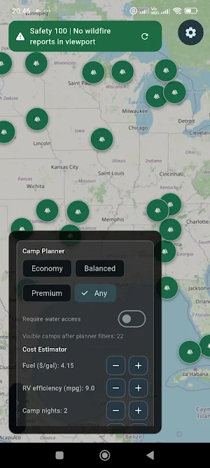


About US Outdoor Navigator
US Outdoor Navigator is a map-first field safety and logistics app for campers and RV travelers across the United States.
Plan smarter, react faster, and travel with more confidence using one operational workflow built for real outdoor conditions. Whether you are preparing a multi-state RV trip or checking local risk before tonight’s stop, the app helps you make better decisions with lower cognitive load.
Core safety visibility
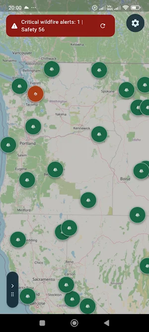
- Wildfire awareness with a clear wildfire map context in your current area
- Weather risk overlays, including severe condition awareness
- Smoke and air quality context to support safer timing decisions
- Road closure signals that can affect RV access and travel time
- Flood and water-risk context when conditions change quickly
RV and camping logistics
- Map-first campground map discovery for practical trip planning
- Nearby logistics points: fuel, water, dump station, propane, repair, grocery, camp supply, market, and EV charging
- Fast “propane near me” and nearest-stop decision support
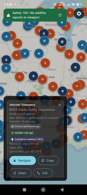
- Emergency points visibility, including hospital, pharmacy, ranger station, sheriff, and fire station
Decision support for the road
- Route Guard with explainable guidance and safer fallback logic
- RV-safe route thinking with access-risk context
- Trip cost planner support for fuel, campground, and logistics budgeting
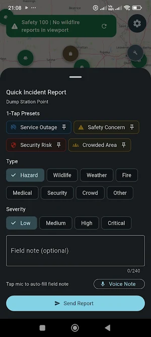
- Quick field reporting workflow, including optional voice-to-text input
Built for field use
- Offline-first behavior with offline bundle support
- Reliable offline map usage in low-signal areas
- Connectivity-aware behavior and practical fallback flows
- Interface designed for readability and fast operation under real travel conditions
Free and Pro
The free tier includes essential safety visibility, core map context, and key logistics layers.
Pro unlocks advanced route rules, expanded offline operations, advanced planning controls, and premium field workflows.
US Outdoor Navigator is an advisory tool. It does not replace emergency services, official road authority guidance, or local regulations. Always follow official instructions and drive responsibly.
Plan smarter, react faster, and travel with more confidence using one operational workflow built for real outdoor conditions. Whether you are preparing a multi-state RV trip or checking local risk before tonight’s stop, the app helps you make better decisions with lower cognitive load.
Core safety visibility
- Wildfire awareness with a clear wildfire map context in your current area
- Weather risk overlays, including severe condition awareness
- Smoke and air quality context to support safer timing decisions
- Road closure signals that can affect RV access and travel time
- Flood and water-risk context when conditions change quickly
RV and camping logistics
- Map-first campground map discovery for practical trip planning
- Nearby logistics points: fuel, water, dump station, propane, repair, grocery, camp supply, market, and EV charging
- Fast “propane near me” and nearest-stop decision support
- Emergency points visibility, including hospital, pharmacy, ranger station, sheriff, and fire station
Decision support for the road
- Route Guard with explainable guidance and safer fallback logic
- RV-safe route thinking with access-risk context
- Trip cost planner support for fuel, campground, and logistics budgeting
- Quick field reporting workflow, including optional voice-to-text input
Built for field use
- Offline-first behavior with offline bundle support
- Reliable offline map usage in low-signal areas
- Connectivity-aware behavior and practical fallback flows
- Interface designed for readability and fast operation under real travel conditions
Free and Pro
The free tier includes essential safety visibility, core map context, and key logistics layers.
Pro unlocks advanced route rules, expanded offline operations, advanced planning controls, and premium field workflows.
US Outdoor Navigator is an advisory tool. It does not replace emergency services, official road authority guidance, or local regulations. Always follow official instructions and drive responsibly.
What’s new
Version 1.0.6 · Updated April 25, 2026
- Improved map usability and panel controls - Better safety and logistics data reliability - Updated premium billing and entitlement flow - Performance and stability improvements
Alternatives to US Outdoor Navigator
Looking for apps like US Outdoor Navigator? Here are 6 similar Android apps on Google Play. The highest rated is Avenza Maps: Offline Mapping (4.5/5), and all 6 are free to download.
-
Wanderz - Travel Guides
-
Hikingbook: Hike, Bike & Run 3.8
-
Optibus Driver 4.4
-
Oddysee: AI Map & Trip Planner
-
Avenza Maps: Offline Mapping 4.5
-
Magic Earth Navigation & Maps 1.8
| App | Rating | Price | Installs | Last updated | Compare |
|---|---|---|---|---|---|
| US Outdoor Navigator | – | Free | 1+ | Apr 25, 2026 | |
| Wanderz - Travel Guides | – | Free | 1,000+ | Sep 30, 2026 | Compare |
| Hikingbook: Hike, Bike & Run | 3.8 / 5 | Free | 100,000+ | Oct 31, 2026 | Compare |
| Optibus Driver | 4.4 / 5 | Free | 10,000+ | Oct 27, 2026 | Compare |
| Oddysee: AI Map & Trip Planner | – | Free | 1,000+ | Jul 9, 2026 | Compare |
| Avenza Maps: Offline Mapping | 4.5 / 5 | Free | 5,000,000+ | Oct 6, 2026 | Compare |
| Magic Earth Navigation & Maps | 1.8 / 5 | Free | 1,000,000+ | Sep 17, 2026 | Compare |
Similar apps on Google Play
- Wanderz - Travel Guides
- Hikingbook: Hike, Bike & Run
- Optibus Driver
- Oddysee: AI Map & Trip Planner
- Avenza Maps: Offline Mapping
- Magic Earth Navigation & Maps
- Skratch: Travel Map & eSIM
- AeroGuest
- Travelfika: Hotels & Flights
- Halter
- FarOut
- Stippl: AI Travel Planner
- HiiKER: The Offline Hiking app
- Multi-Stop Route Planner
- what3words: Navigation & Maps
- SmartGuide: Digital Tour Guide
- Roadtrippers - Trip Planner
- GPX Viewer PRO: Hike & Bike
- National Park Service
- Outdooractive. Hike and Ride
- A Better Routeplanner (ABRP)
- Chargeway
- TomTom - Maps & Traffic
- Blue Sky Vitamin
- RentCheck
- Discover Tasmania Travel Guide
- VoiceMap: Audio Tours & Guides
- OneTravel: Flights Hotels Cars
- Hipcamp: Camping, RVs & Cabins
- Solo: Your Gig Business App
- Tripomatic Planner & Maps
- Chipolo
- Gaia GPS: Offline Trail Maps
- Drive Smarter
- Freetour.com - travel app
- OsmAnd — Maps & GPS Offline
- TrailLink: Bike, Run, Walk
- Zeo Fast Multi Stop Route Plan