BackTrack GPS & Compass
Offline GPS navigation, maps, compass, waypoints and GPX track recording.
About BackTrack GPS & Compass
🛰️ BackTrack GPS Navigator
Offline GPS Navigator, GPS Compass, Offline Maps, Waypoints and GPX Track Recording.
No ads. No tracking. No accounts. No cloud.
BackTrack is a free offline GPS navigation app built for hiking, hunting, fishing, kayaking, geocaching, mushroom picking, overlanding and outdoor adventures.
Navigate without internet access, save waypoints, record tracks, view GPS coordinates and always find your way back.
━━━━━━━━━━━━━━
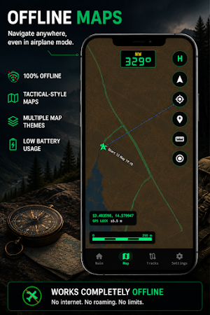
🗺️ OFFLINE GPS NAVIGATION
Use GPS navigation anywhere, even without mobile coverage.
• Offline maps
• Offline GPS navigation
• Airplane mode support
• Fast GPS positioning
• Low battery usage
• GPS location tracking
Perfect for forests, mountains, lakes, trails and remote areas.
━━━━━━━━━━━━━━
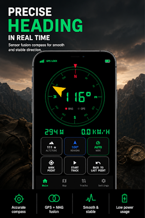
🧭 GPS COMPASS & SMART HEADING
Reliable heading information wherever you go.
Choose between:
• IMU Fusion AUTO
• GPS Heading
• Magnetic Compass
BackTrack combines gyroscope, magnetometer and GPS data to provide smooth and stable compass performance.
Unlike many compass apps, heading remains usable even in challenging outdoor conditions.
━━━━━━━━━━━━━━
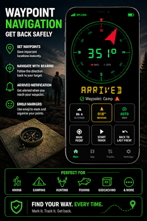
📍 SAVE WAYPOINTS
Never lose important locations again.
Save:
• Parking locations
• Fishing spots
• Hunting stands
• Campsites
• Mushroom areas
• Geocache locations
• Survey points
• Custom destinations
Use emoji markers for fast waypoint identification.
━━━━━━━━━━━━━━
📁 TRACK RECORDING & GPX EXPORT
Record and manage your routes.
• GPS track recording
• GPX export
• Route history
• Distance tracking
• Outdoor activity logging
Perfect for hiking, off-road navigation and exploration.
━━━━━━━━━━━━━━
📏 OUTDOOR NAVIGATION TOOLS
Useful tools for navigation and field work.
• Distance measurement
• Bearing display
• Heading display
• Navigate back to waypoints
• Sunrise and sunset times
• GPS coordinates
• Accurate altitude correction (EGM2008 geoid)
━━━━━━━━━━━━━━
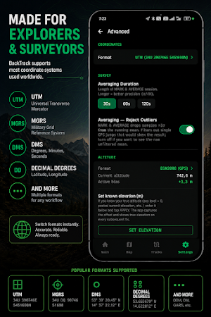
🌍 MULTIPLE COORDINATE SYSTEMS
Supports popular coordinate formats.
• Latitude / Longitude
• UTM
• MGRS
• DMS
• Decimal Degrees
Ideal for navigation, surveying, mapping and outdoor use.
━━━━━━━━━━━━━━
🔋 BUILT FOR THE FIELD
Designed for real outdoor conditions.
• Low battery consumption
• Offline operation
• Fast startup
• No subscriptions
• No user account required
━━━━━━━━━━━━━━
🔒 PRIVATE BY DESIGN
Your location data stays on your device.
• No tracking
• No analytics
• No cloud services
• No personal data collection
━━━━━━━━━━━━━━
⚡ PERFECT FOR
• Hiking
• Hunting
• Fishing
• Kayaking
• Geocaching
• Mushroom picking
• Overlanding
• Off-road navigation
• Outdoor adventures
• Survey field work
━━━━━━━━━━━━━━
Whether you need an Offline GPS Navigator, GPS Compass, Offline Maps, Waypoint Manager, GPX Track Recorder, Hiking GPS, Hunting GPS, Fishing GPS, Geocaching GPS, GPS Coordinates tool or Outdoor Navigation app, BackTrack helps you navigate with confidence anywhere.
Popular features:
Offline GPS • GPS Navigator • GPS Compass • Offline Maps • GPS Coordinates • Waypoints • GPX Export • Hiking GPS • Hunting GPS • Fishing GPS • Geocaching • Track Recording • UTM • MGRS • Outdoor Navigation • Sensor Fusion Compass
Similar Apps

Voice Changer – Real Time
Real-Time Voice Changer, Pitch Correction, Vocoder & DSP Effects

Mic Monitor – Real Time Voice
Low-latency mic monitor with real-time voice feedback
EchoFlow Voice Delay DAF
Real-time voice delay (DAF) for speech training.

