


Spyglass is an essential offline GPS app for outdoors and off-road navigation. Packed with tools it serves as binoculars, heads-up display, hi-tech compass with offline maps, gyrocompass, GPS receiver, waypoint tracker, speedometer, altimeter, Sun, Moon and Polaris star finder, gyro horizon, rangefinder, sextant, inclinometer, angular calculator and camera. It saves a custom location, navigates precisely to it later, shows it on maps and using augmented reality displays detailed GPS info, measures distances, sizes, angles, and does a lot more.
IMPORTANT NOTE ON ANDROID RELEASE
One of the best cross-country GPS navigation tools is now available on Android. Most features are implemented, however, some features available on other platforms are to be done. Also, instead of having multiple apps, on Android it is a single free app with a paid unlock of premium features. Be patient and report bugs, if any, directly via our email or the support page.
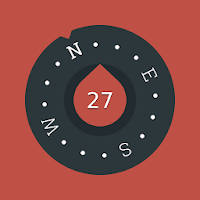
COMPASS & GYROCOMPASS
Accuracy improvement techniques, special compass modes and calibration methods available in Spyglass only make it a real instrument – the most advanced and accurate digital compass.
FINDER, TRACKER & AR NAVIGATION
Spyglass operates in 3D and uses augmented reality to show object positions, info and directions to them overlaid over camera or maps.
Save current position, add a point from maps, manually enter location coordinates.
Find the saved place later simply by following directional arrows.
Spyglass tracks your target and shows its info – distance, direction, azimuth, elevation and estimated time of arrival.
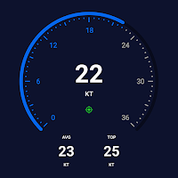
GPS, SPEEDOMETER & ALTIMETER
Find and track your location and get detailed GPS data – coordinates in dozens of formats, altitude, course, current, maximum and vertical speed, using imperial, metric, nautical and surveying units.
OFFLINE MAPS
See your and targets’ positions on maps using different map styles and alternative map providers – plan waypoints and measure distances. Offline maps optimized for retina displays are available for download.
TRACK POLARIS, SUN AND MOON & NAVIGATE BY STARS
Track positions of Polaris, Sun and Moon with arc second precision – use them as a reference to calibrate compass for maximum accuracy.
OPTICAL RANGEFINDER
Measure distances to objects in real time with a rangefinder reticle similar to sniper sights.
SEXTANT, ANGULAR CALCULATOR AND INCLINOMETER
Find out heights of objects and distances to them – measure visually and calculate dimensions and distances.
CAMERA
Take pictures overlaid with all available GPS, positional and directional data.
DEMO & HELP
Videos:
http://j.mp/spyglass_vids
Manuals:
http://j.mp/spyglass_help

A simple and easy to use Compass to retrieve useful information about...
A magnetic compass with magnetic declination correction for best accuracy. A compass...
Mariner GPS Dashboard for Android and Wear OS calculates your speed in...

Compass GM is a gyro-magnetic compass app that accurately indicates true or...
Please watch the teach video to know how to use it.When you...


Created with AppPage.net
Similar Apps - visible in preview.