
TsuriDEX - 等深線と海底地形の釣りマップ
Lach Stud Sports In-app purchases
Predicts prime fishing spots based on topography and water depth. Also includes tide tables and AI analysis.
- Downloads
- 79+
- on Google Play
- Price
- Free
- In-app purchases
- Updated
- Sep 18
- 2026 · v1.2.2
Screenshots



About TsuriDEX - 等深線と海底地形の釣りマップ
Find the best fishing spots at a glance.
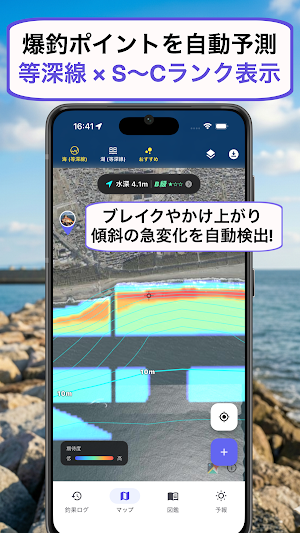
"TsuriDEX" is a next-generation map app for anglers that evaluates and visualizes fish hiding spots with a ranking system from S to C, based on water depth and terrain changes.
From scouting fishing spots in advance to AI-powered size measurement from photos and catch analysis, it powerfully supports your fishing life, from beginners to veterans.
[Its greatest strength: A high-performance map that shows the best fishing spots]
This is not just a map. In addition to seabed "water depth" and "contour lines," the AI analyzes bottom quality data such as sudden depth changes (breaks and drop-offs). Promising areas where fish are likely to be found are directly displayed on the map with S, A, B, and C rankings. If downloaded in advance, it can be used as a GPS offline map even in offshore reefs or mountain streams without cell service.*
[Other key features]
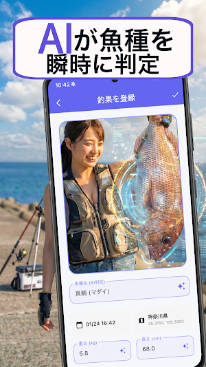
■ AI automatically identifies and measures fish
Simply take a picture of your caught fish with your smartphone. The latest AI instantly identifies the "name of the fish" and accurately estimates its "size (length and weight)." You can record your catch digitally, like a digital fish print, without the hassle of using a measuring tape.
■ "Sea Conditions Forecast" Directly Impacting Your Catch
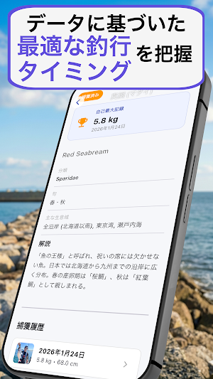
In addition to weather forecasts, you can check wind direction and speed, wave height, and detailed tide graphs (tide tables) up to 7 days in advance, allowing you to plan your optimal fishing trip. *
■ Your Personalized "Fishing Analysis Dashboard"
Based on recorded data, it visualizes your "winning patterns." The AI automatically calculates the successful conditions for tidal cycles, wind direction, and water temperature that you often use. *
■ Fishing Tackle Inventory
Register and manage your favorite rods, reels, lines, etc. Link it to your fishing diary to record in detail which tackle you used to catch fish.
【Support & Inquiries】
If you have any feature requests or bug reports, please feel free to contact us through the settings screen within the app. We are constantly evolving for Japanese anglers.
Features marked with an asterisk (*) can be used without limit by upgrading to the paid plan "TsuriDEX Pro".
Alternatives to TsuriDEX - 等深線と海底地形の釣りマップ
Looking for apps like TsuriDEX - 等深線と海底地形の釣りマップ? Here are 6 similar Android apps on Google Play. The highest rated is Football Live TV HD 2026 (4.7/5), and all 6 are free to download.
-
Rallia - Tennis & Pickleball
-
World Cup 2026: Live & Predict
-
Football Live TV HD 2026 4.7
-
Skill Shot Golf
-
Impian Golf & Country Club
-
Gal sport
| App | Rating | Price | Installs | Last updated | Compare |
|---|---|---|---|---|---|
| TsuriDEX - 等深線と海底地形の釣りマップ | – | Free | 50+ | Sep 18, 2026 | |
| Rallia - Tennis & Pickleball | – | Free | 100+ | Sep 1, 2026 | Compare |
| World Cup 2026: Live & Predict | – | Free | 100+ | Jun 17, 2026 | Compare |
| Football Live TV HD 2026 | 4.7 / 5 | Free | 100+ | Jul 18, 2026 | Compare |
| Skill Shot Golf | – | Free | 5,000+ | Jul 14, 2026 | Compare |
| Impian Golf & Country Club | – | Free | 100+ | Oct 11, 2026 | Compare |
| Gal sport | – | Free | 10+ | Jul 17, 2026 | Compare |
Similar apps on Google Play
- Rallia - Tennis & Pickleball
- World Cup 2026: Live & Predict
- Football Live TV HD 2026
- Skill Shot Golf
- Impian Golf & Country Club
- Gal sport
- E&DCL
- SÓLIGA!
- Playball Campeonatos
- Evelien Hockey Watch Face G3
- BetaSport
- Challengers Azerbaijan
- Evelien Hockey Watch Face
- KS Polonia Warszawa
- Queensland GAA
- العب ويانة
- CompiFit
- Yacine TV
- Cricket Hub - Live Scores
- Elite Sure Tips
- Tour des Yoles
- Live Cricket TV HD
- Betsson
- JEP
- Portal Gracza Rummikub