
SGS MinFinder
Simple Geospatial Solutions Maps & Navigation In-app purchases
Offline BC MINFILE mineral occurrence map for prospectors & geologists
- Downloads
- 315+
- on Google Play
- Price
- Free
- In-app purchases
- Updated
- Sep 27
- 2026 · v1.2.0
Screenshots
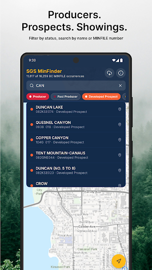


About SGS MinFinder
16,000+ OCCURRENCES, FULLY OFFLINE
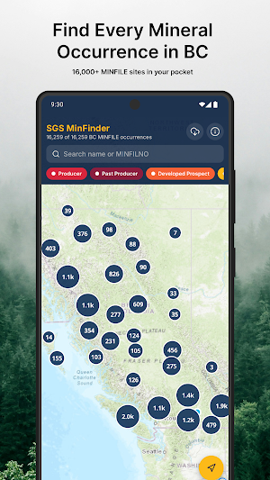
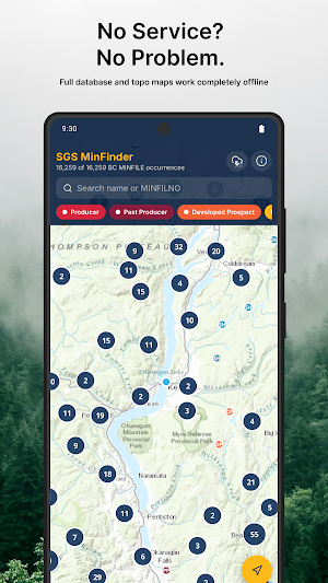
Every MINFILE occurrence is bundled in the app in a local database. Browse, search, and filter the whole province with no data connection. Pre-download topographic map tiles for the area you're heading to and the basemap works offline too.
BUILT FOR THE FIELD
- Map every occurrence across BC, clustered so the big picture is instantly clear.
- Filter by status - Producer, Past Producer, Developed Prospect, Prospect, Showing, Anomaly - each colour-coded on the map.
- Search by name or MINFILE number and fly straight to any site.
- Real topographic basemaps from Esri so terrain, contours, and access roads are right there.
THE FULL GEOLOGICAL RECORD
Tap any occurrence for the official details: status, host rock, deposit class, elevation, latitude/longitude (decimal and DMS), and UTM coordinates in both NAD27 and NAD83. One tap opens the official BC MINFILE record online.
NAVIGATE TO THE SITE (Premium)
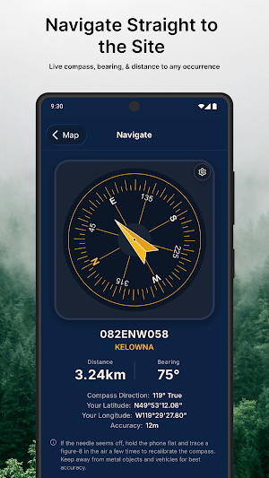
A live compass dial with real-time bearing and distance guides you to the exact occurrence - no trail required.
DOWNLOAD YOUR REGION BEFORE YOU GO
Draw a box around any area and cache its topographic tiles for offline use. Manage, reopen, or clear your downloaded regions any time.
PREMIUM
A one-time or subscription purchase unlocks compass navigation and the full expanded occurrence details. The map, search, filtering, and offline region downloads are free.
DATA SOURCES
Mineral data: BC Ministry of Energy, Mines and Low Carbon Innovation (MINFILE), https://minfile.gov.bc.ca/. Basemap: Esri World Topographic Map.
SGS MinFinder is an independent, third-party app. It is not affiliated with, endorsed by, or operated by the Government of British Columbia or any government agency.
Use as a reference only. Always verify mine status, land access, and safety information before visiting any site.
What’s new
Version 1.2.0 · Updated September 27, 2026
Field reports: every MINFILE mine now has Reports and Comments. Post where the workings really are, add photos, and vote on other visitors' reports. Reports made offline send when you're back in signal. Pro shows each report's exact spot on the map. Also new: a cleaner map-first design, one swipeable mine sheet, the menu in the search bar, and remembered filters. Fixed the map reloading when the menu opens on Android.
User reviews

What an incredibly valuable tool. Wish I had this years ago. It would have saved soo much time. I do a lot of mine research and exploration. Why didn't someone think of this sooner?
Alternatives to SGS MinFinder
Looking for apps like SGS MinFinder? Here are 6 similar Android apps on Google Play. The highest rated is Offline GPS & Mining (4.6/5), and all 6 are free to download.





| App | Rating | Price | Installs | Last updated | Compare |
|---|---|---|---|---|---|
| SGS MinFinder | – | Free | 100+ | Sep 27, 2026 | |
| Gofastgo Partner | – | Free | 1+ | Jul 24, 2026 | Compare |
| UDAAN RIDE PARTNER | – | Free | 100+ | Sep 2, 2026 | Compare |
| Offline GPS & Mining | 4.6 / 5 | Free | 1,000+ | – | Compare |
| كابتن ران | – | Free | 10+ | Aug 7, 2026 | Compare |
| Mushroom Picker | – | Free | 1,000+ | Sep 10, 2026 | Compare |
| TutaxiApp | – | Free | 100+ | Aug 23, 2026 | Compare |
Compare SGS MinFinder with the top alternatives: ratings, updates, ASO score and keyword gaps →
Similar apps on Google Play
- Gofastgo Partner
- UDAAN RIDE PARTNER
- Offline GPS & Mining
- كابتن ران
- Mushroom Picker
- TutaxiApp
- GPS Speedometer and Odometer
- Vigie - Speed Camera & GPS
- BoatLynk
- Miofive AR Speedcam
- Con Cuidado
- Mega Navigator
- WayFairer
- Transporte Público Durango
- DoorToDoor Cab Partner
- SARATHI PARTNER
- Manko Driver
- Rider Aaspaass
- Taxiforride Partner
- Smart Nav Maps & GPS
- SG-JB Traffic: Causeway Cams
- Nexora
- Pintaz
- SARATHI
- KV CABS