


Coastal Navigation
Lines of position: bearing, range, horizontal angle.
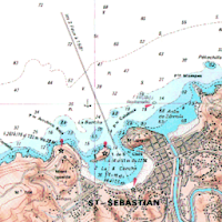
Plot on Google Maps.
OPERATION
-------------------
1 - Select the type of coastal line of position: [Bearing], [Range] or [Horizontal angle].
2 - Enter its value.
3 - (Long click) the point/s of the sight.
Then the app plots the LoP on the map.
You can check the accuracy of your observations against GNSS
Permissions:
---------------------
- Location App permission must be allowed
- WRITE_EXTERNAL_STORAGE
Map controls and gestures:
--------------------------------------------
GPS location
- Switch on your GPS, and then automatic location detection is possible
- Push My Location button
Zoom
- Zoom buttons +/-
- Double tap to increase the zoom level by 1 (zoom in)
- Two finger tap to decrease the zoom level by 1 (zoom out)
- Two finger pinch/stretch
- One finger zooming by double tapping but not releasing on the second tap, and then sliding the finger up to zoom out, or down to zoom in
Scroll (pan)
- A user can pan around the map by dragging the map with their finger
Tilt
- A user can tilt the map by placing two fingers on the map and moving them down or up together to increase or decrease the tilt angle respectively
Rotate
- A user can rotate the map by placing two fingers on the map and applying a rotate motion.

Nautical astronomy (Celestial navigation, Astronavigation): - Latitude by Polaris - Latitude by...
Celestial navigation - AstronavigationSight reduction: - Marcq Saint Hilaire Line of Position,...

Sailing is a method of solving the various problems involving course, distance,...

Celestial navigation - AstronavigationFor training or improving your skills with a marine...

Celestial navigation.Fix by two circles of position: vector solution.With a sextant take...

Variation for the current day.Used in navigation with a magnetic compass.-Variation is...
Created with AppPage.net
Similar Apps - visible in preview.