Back to Top
Sextant Screenshot 0
Sextant Screenshot 1
Sextant Screenshot 2
Sextant Screenshot 3
Free website generator for mobile apps; privacy policy, app-ads.txt support and more... AppPage.net

About Sextant

Celestial navigation - Astronavigation

For training or improving your skills with a marine sextant, an aircraft octant (bubble), an artificial horizon, or a theodolite.
- Real time calculation of the instrumental altitude Hs for comparison of your shots.
- Useful for index error determination.
- For Sun, Moon, and navigational stars and planets.
- Location on map of your position by GPS or manually. ("Location" App permission must be allowed. Switch on you GPS, and then automatic location detection is possible)
- Map: zoom, satellite, terrain and road map.

Similar Apps

Sailings

Sailings

3.9

Sailing is a method of solving the various problems involving course, distance,...

Coastal Navigation

Coastal Navigation

0.0

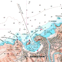
Coastal NavigationLines of position: bearing, range, horizontal angle.Plot on Google Maps.OPERATION-------------------1 -...

Vector solution 2 CoP

Vector solution 2 CoP

0.0

Celestial navigation.Fix by two circles of position: vector solution.With a sextant take...

Variation

Variation

4.6

Variation for the current day.Used in navigation with a magnetic compass.-Variation is...

Sight reduction

Sight reduction

4.2

Celestial navigation - AstronavigationSight reduction: - Marcq Saint Hilaire Line of Position,...

Nautical Astronomy

Nautical Astronomy

4.4

Nautical astronomy (Celestial navigation, Astronavigation): - Latitude by Polaris - Latitude by...

Frequently Asked Questions(FAQ)

What is a sextant?

A sextant is a navigational instrument used for celestial navigation and astronavigation.

What can a sextant be used for?

A sextant can be used for training or improving skills in using a marine sextant, an aircraft octant (bubble), an artificial horizon, or a theodolite. It can also calculate the instrumental altitude Hs for comparison of shots, help determine index error, and be used for taking measurements of the Sun, Moon, and navigational stars and planets.

Can a sextant help determine the location on a map?

Yes, a sextant can help determine the location on a map either by using GPS or manually. However, it requires the "Location" App permission to be allowed and the GPS to be switched on for automatic location detection.

What map features are available on a sextant?

The sextant provides various map features such as zoom, satellite view, terrain view, and road map view.
author
Excellent. Most enjoyable to use.
Monsoon Groover