Coastal Navigation
100+
Downloads

Everyone
info
About this app
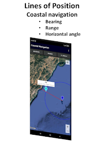
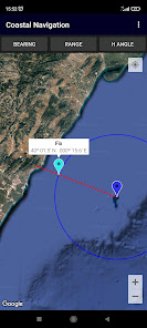
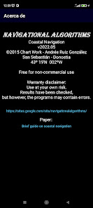
Coastal Navigation
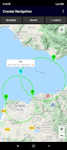
Lines of position: bearing, range, horizontal angle.
Plot on Google Maps.
OPERATION
-------------------
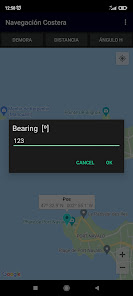
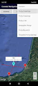
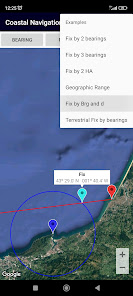
1 - Select the type of coastal line of position: [Bearing], [Range] or [Horizontal angle].
2 - Enter its value.
3 - (Long click) the point/s of the sight.
Then the app plots the LoP on the map.
You can check the accuracy of your observations against GNSS
Permissions:
---------------------
- Location App permission must be allowed
- WRITE_EXTERNAL_STORAGE
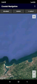
Map controls and gestures:
--------------------------------------------
GPS location
- Switch on your GPS, and then automatic location detection is possible
- Push My Location button
Zoom
- Zoom buttons +/-
- Double tap to increase the zoom level by 1 (zoom in)
- Two finger tap to decrease the zoom level by 1 (zoom out)
- Two finger pinch/stretch
- One finger zooming by double tapping but not releasing on the second tap, and then sliding the finger up to zoom out, or down to zoom in
Scroll (pan)
- A user can pan around the map by dragging the map with their finger
Tilt
- A user can tilt the map by placing two fingers on the map and moving them down or up together to increase or decrease the tilt angle respectively
Rotate
- A user can rotate the map by placing two fingers on the map and applying a rotate motion.
Lines of position: bearing, range, horizontal angle.
Plot on Google Maps.
OPERATION
-------------------
1 - Select the type of coastal line of position: [Bearing], [Range] or [Horizontal angle].
2 - Enter its value.
3 - (Long click) the point/s of the sight.
Then the app plots the LoP on the map.
You can check the accuracy of your observations against GNSS
Permissions:
---------------------
- Location App permission must be allowed
- WRITE_EXTERNAL_STORAGE
Map controls and gestures:
--------------------------------------------
GPS location
- Switch on your GPS, and then automatic location detection is possible
- Push My Location button
Zoom
- Zoom buttons +/-
- Double tap to increase the zoom level by 1 (zoom in)
- Two finger tap to decrease the zoom level by 1 (zoom out)
- Two finger pinch/stretch
- One finger zooming by double tapping but not releasing on the second tap, and then sliding the finger up to zoom out, or down to zoom in
Scroll (pan)
- A user can pan around the map by dragging the map with their finger
Tilt
- A user can tilt the map by placing two fingers on the map and moving them down or up together to increase or decrease the tilt angle respectively
Rotate
- A user can rotate the map by placing two fingers on the map and applying a rotate motion.
Updated on
Safety starts with understanding how developers collect and share your data. Data privacy and security practices may vary based on your use, region, and age. The developer provided this information and may update it over time.

No data shared with third parties
Learn more about how developers declare sharing

No data collected
Learn more about how developers declare collection


