Shenandoah Safari Guide & Map
Offline map, wildlife guide & sightings log for Shenandoah National Park

About Shenandoah Safari Guide & Map
Shenandoah National Park — your complete wildlife guide, in your pocket and fully offline.
Whether it's your first visit or your tenth, Shenandoah Safari helps you find your way, identify every animal, and remember every sighting — no signal required.
FIND YOUR WAY, OFFLINE
• A detailed offline map of the whole park — campgrounds, entrance stations, roads and points of interest
• Orientation deep in the backcountry with no data connection — never miss a turn on a wildlife drive again
IDENTIFY EVERY ANIMAL
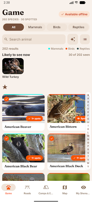
• 202 species — mammals, birds and reptiles — each with high-quality photos
• Smart search: filter by type, search by name, or use the "describe the animal" helper to identify what you just saw
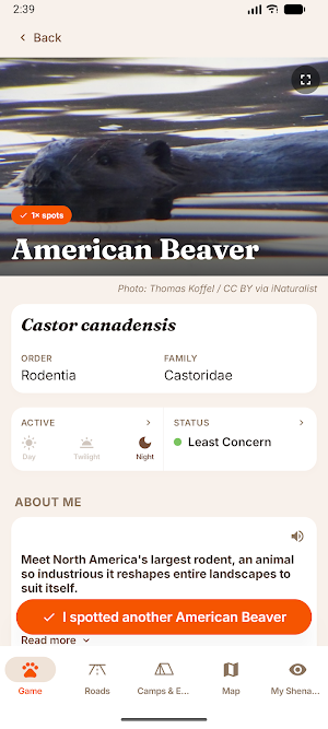
• Behavior, habitat and the best time and place to spot each one
PLAN THE PERFECT DRIVE
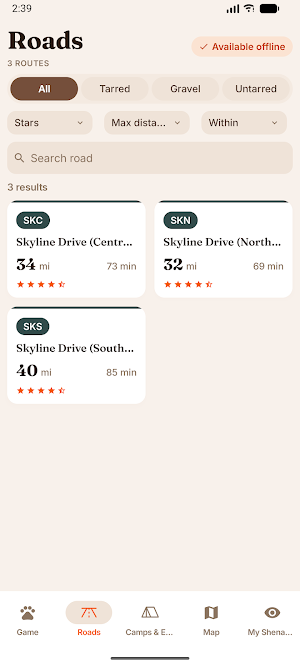
• 3 scenic drives, each with distance, drive time, surface and a star rating
• Know before you go: 9 campgrounds and entrance stations with photos, facilities and tips
KEEP YOUR SAFARI DIARY
• Log every sighting in a single tap and build your personal Shenandoah journal across visits
• Earn badges as you explore and track your own statistics — your most-spotted species and more
WORKS ANYWHERE
Everything runs offline, so you save data and battery while you're in the park.
LANGUAGES
English, Spanish, French, German, Dutch, Portuguese and Italian.
WILDLIFE YOU CAN LOOK FOR
American Black Bear, White-tailed Deer, Wild Turkey, Bobcat and Coyote are the animals most visitors hope to see. All 202 species in the park are in the guide, from Bald Eagle to Red Fox.
WHERE TO GO
Skyline Drive (South District) (39.8 mi, about an hour) is the classic wildlife drive. Every stop along the way is covered — Bacon Hollow Overlook, Bald Face Mountain Overlook, Beagle Gap Overlook, Beahms Gap Overlook and Bear Church Rock Overlook. You'll also find Big Meadows Campground, Loft Mountain Campground and Mathews Arm Campground, plus Front Royal Entrance, Thornton Gap Entrance and Swift Run Gap Entrance — each with photos, facilities and tips.
FREQUENTLY ASKED
Does it work without a signal? Yes. Map, species guide and sightings log all work fully offline once downloaded.
Do I need to plan ahead? No. Open any drive and see its length, driving time, surface and which animals are seen along it most often.
Is it useful before I go? Yes. Read up at home, and your sightings diary carries over between visits.
SUBSCRIPTION
Unlock the full experience — offline maps, road and campground guides, the wildlife encyclopedia, the safari logger and your personal insights — with a weekly, monthly or yearly subscription. Payment will be charged to your Google Play account upon confirmation of purchase. Subscriptions automatically renew unless auto-renew is turned off at least 24 hours before the end of the current period. You can manage your subscription and auto-renewal settings in your Google Play Account Settings.
More national park apps in the Safari Guy family are on the way.
Feature image: Brian Gratwicke / CC-BY via iNaturalist
Privacy Policy: https://thesafariguy.co.za/privacy-policy/
Similar Apps

Yosemite Wildlife Safari & Map
Offline map, wildlife guide & sightings log for Yosemite National Park

Wind Cave Safari Guide & Map
Offline map, wildlife guide & sightings log for Wind Cave National Park

Yellowstone Safari Guide & Map
Offline map, wildlife guide & sightings log for Yellowstone National Park

Theodore Roosevelt Safari
Offline map, wildlife guide & sightings log for Theodore Roosevelt National Park

Rocky Mountain Safari & Map
Offline map, wildlife guide & sightings log for Rocky Mountain National Park

Olympic Wildlife Safari & Map
Offline map, wildlife guide & sightings log for Olympic National Park
