

Pix4Dcatch: 3D scanner
Pix4D Tools
3D models from images and AR
- Rating
- 3.6
- 655 ratings
- Downloads
- 153K+
- on Google Play
- Price
- Free
- No in-app purchases
- Updated
- Oct 18
- 2025 · v1.30.0
Screenshots


About Pix4Dcatch: 3D scanner
Pix4Dcatch is the tool for acquiring optimal ground images for photogrammetry. These ground images can be uploaded to PIX4Dcloud to get highly accurate 3D models (free 15-day trial available, then a valid subscription is required). The images can also be exported offline for free to photogrammetry software such as PIX4Dmatic.
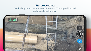
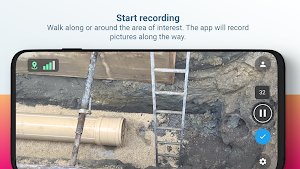
No need to be an expert. Walk around your area of interest and the app will record pictures along the way, together with GPS positions.
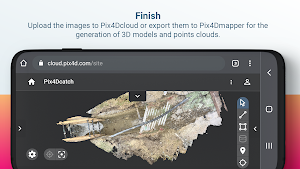
Images can be uploaded to Pix4Dcloud for the fast generation of scaled and georeferenced 3D models and point clouds that you can visualize, measure, share, and export. Or they can be exported locally for processing in Pix4Dmapper.
Workflow
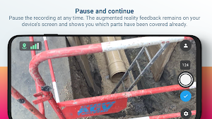
1 - Scan: Walk around the area of interest. Pix4Dcatch automatically records geotagged frames and displays on your screen real-time 3D meshing for scene completion feedback.
2a- Upload: Stop recording and automatically upload images to Pix4Dcloud to generate accurate and easy to share 3D models (requires a Pix4Dcloud subscription - free 15 day trial available).
2b - Or export: transfer the images from your device to your desktop computer and start the photogrammetry process, add GCPs and validate the accuracy of your 3D scene with Pix4Dmapper (requires a Pix4Dmapper subscription - free 15 day trial available).
3 - Examine: Measure distances, areas, and volumes, and perform virtual inspections.
4 - Share: Selectively and securely share project data and insights with your team, clients, and suppliers.
Devices compatibility:
All ARCore enabled devices.
Google Play Services for AR needs to be installed in order to use the app.
Usage information
Ensure the app is up to date. Upload the images to Pix4Dcloud to generate, visualize, measure and share your 3D model.
Pix4D accepts no liability for damage, injuries or legalities from the misuse of this app. Use only in safe environments.
No need to be an expert. Walk around your area of interest and the app will record pictures along the way, together with GPS positions.
Images can be uploaded to Pix4Dcloud for the fast generation of scaled and georeferenced 3D models and point clouds that you can visualize, measure, share, and export. Or they can be exported locally for processing in Pix4Dmapper.
Workflow
1 - Scan: Walk around the area of interest. Pix4Dcatch automatically records geotagged frames and displays on your screen real-time 3D meshing for scene completion feedback.
2a- Upload: Stop recording and automatically upload images to Pix4Dcloud to generate accurate and easy to share 3D models (requires a Pix4Dcloud subscription - free 15 day trial available).
2b - Or export: transfer the images from your device to your desktop computer and start the photogrammetry process, add GCPs and validate the accuracy of your 3D scene with Pix4Dmapper (requires a Pix4Dmapper subscription - free 15 day trial available).
3 - Examine: Measure distances, areas, and volumes, and perform virtual inspections.
4 - Share: Selectively and securely share project data and insights with your team, clients, and suppliers.
Devices compatibility:
All ARCore enabled devices.
Google Play Services for AR needs to be installed in order to use the app.
Usage information
Ensure the app is up to date. Upload the images to Pix4Dcloud to generate, visualize, measure and share your 3D model.
Pix4D accepts no liability for damage, injuries or legalities from the misuse of this app. Use only in safe environments.
What’s new
Version 1.30.0 · Updated October 18, 2025
What's new: - Handled organization Access-Control Lists (ACL) for member roles when logging in, opening the account dialog, or uploading to PIX4Dcloud.
User reviews

Phenomenal. I frickin love this app. Wish I had known about it before now, it would have saved my life.
Is almost as use Lidar on the new iphone12
Frequently asked questions
What is Pix4Dcatch?
Pix4Dcatch is a tool for acquiring ground images for 3D scanning and photogrammetry.
How can I use Pix4Dcatch?
Simply walk around your area of interest and the app will automatically record geotagged frames with GPS positions.
What can I do with the images captured by Pix4Dcatch?
The images can be uploaded to Pix4Dcloud to generate highly accurate 3D models, or exported for processing in photogrammetry software like Pix4Dmapper.
How can I upload my images to Pix4Dcloud?
You can stop recording in Pix4Dcatch and the images will be automatically uploaded to Pix4Dcloud. A Pix4Dcloud subscription is required for this feature.
Can I export the images for offline processing?
Yes, you can transfer the images from your device to your desktop computer and process them in Pix4Dmapper. A Pix4Dmapper subscription is required for this feature.
What can I do with the 3D models and point clouds generated by Pix4Dcloud?
You can visualize, measure, share, and export the scaled and georeferenced 3D models and point clouds.
What devices are compatible with Pix4Dcatch?
Pix4Dcatch is compatible with all ARCore enabled devices.
Do I need to install Google Play Services for AR to use Pix4Dcatch?
Yes, Google Play Services for AR needs to be installed in order to use the app.
Are there any usage precautions for Pix4Dcatch?
Ensure the app is up to date and use it only in safe environments. Pix4D accepts no liability for any damage, injuries, or legalities resulting from the misuse of the app.
Alternatives to Pix4Dcatch: 3D scanner
Looking for apps like Pix4Dcatch: 3D scanner? Here are 6 similar Android apps on Google Play. The highest rated is WIDAR - 3D Scan & Edit (4.3/5), and all 6 are free to download.
-
WIDAR - 3D Scan & Edit 4.3
-
Polycam - 3D Scanner 4.1
-
HOVER - Measurements in 3D 3.6
-
Pawscout 3.4
-
Bosch MeasureOn 3.6
-
ImageMeter - photo measure 3.2
| App | Rating | Price | Installs | Last updated |
|---|---|---|---|---|
| Pix4Dcatch: 3D scanner | 3.6 / 5 | Free | 100,000+ | Oct 18, 2025 |
| WIDAR - 3D Scan & Edit | 4.3 / 5 | Free | 500+ | Mar 18, 2022 |
| Polycam - 3D Scanner | 4.1 / 5 | Free | 1,000,000+ | Sep 14, 2026 |
| HOVER - Measurements in 3D | 3.6 / 5 | Free | 1,000,000+ | Sep 17, 2026 |
| Pawscout | 3.4 / 5 | Free | 100,000+ | Mar 30, 2026 |
| Bosch MeasureOn | 3.6 / 5 | Free | 50,000+ | Sep 2, 2026 |
| ImageMeter - photo measure | 3.2 / 5 | Free | 5,000,000+ | Sep 3, 2026 |