Desnivel+: Trail Running Hills
Find the perfect climb for your trail running intervals. Exact distance & %.
About Desnivel+: Trail Running Hills
Hill repeat day? Desnivel+ finds the exact climb you need: specific gradient, specific length, near you.
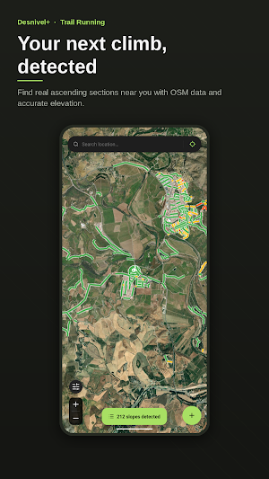
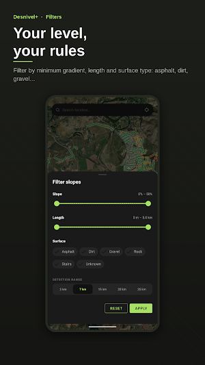
For workouts like "8×200 m at 10%" or "4×1 km at 6%" — no more driving around testing random hills. Filter by distance and gradient, the app draws the matching climbs on the map, you pick.
Built for trail runners who train with a plan: hill repeats, short reps, long climbs for endurance, urban stairs for strength. Also great for cyclists, hikers and anyone hunting elevation gain (D+).
HOW IT WORKS
The app analyzes real paths from OpenStreetMap and combines them with high-resolution elevation data to detect uphill segments. No imaginary roads: only trails, tracks, stairs and paths that actually exist.
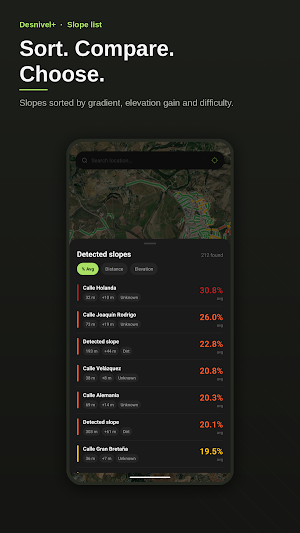
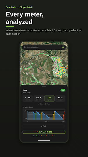
Every detected climb includes:
• Average and maximum gradient
• Length and total elevation gain (D+)
• Difficulty: Easy, Medium, Hard or Extreme
• Surface type: asphalt, dirt, gravel, stairs or rock
• Detailed elevation profile
WHAT YOU USE IT FOR
• Hill repeats and short reps for speed work
• Long climbs for endurance and vertical training
• Uphill running routes with measured gradient
• Urban stairs for strength sessions
• Filtered selections by gradient and length so every session is controlled
FREE
• Automatic detection in a 7 km radius around you
• Filters by gradient, length and surface type
• Search any location worldwide
• Normal and satellite map view
• Full climb detail with elevation profile
• Reverse climb direction to preview the descent
DESNIVEL+ PRO
Take your training further:
• Adjustable radius up to 25 km — explore far beyond your usual area
• Favorites — save your go-to climbs and jump back in with a tap
• Measure tool — draw your own route and get distance and elevation gain instantly
• Saved routes — store your laps and plan your sessions
• Offline maps — download areas to train without signal
• Open in Google Maps — launch turn-by-turn navigation to the start of any climb
PLANS
• Monthly subscription: cancel anytime
• One-time lifetime purchase: pay once, use forever, no renewals
PRIVACY & DATA
• No ads
• No third-party tracking
• Your location is only used to find climbs near you, never sent to any server
• Map data: OpenStreetMap · Elevation data: OpenTopoData (SRTM)
WHO IT'S FOR
• Trail runners chasing hill repeats and long climbs
• Road and MTB cyclists looking for fresh elevation routes
• Hikers planning sessions with vertical gain
• Urban runners hunting stairs or ramps for strength work
• Travelers who want to discover running hills near them in unfamiliar areas
No hidden fees. No ads. No notification spam. Just climbs, data and your legs.
Similar Apps

MyFitOrbit Gym Workout Tracker
9,000+ exercises with video demos, smart plans & progress tracking

Courts Plus Community Fitness
Courts Plus has the amenities you need for a healthy lifestyle in the F-M area

Peptide Paradigm
Peptide dose calculator, tracker and research library for 132 compounds.

Studio Fitness
Application for students of Studio Fitness

ZoneCoach
Train smarter: heart-rate zone coaching with adaptive intervals and AI plans.

WaterBuddy: Hydration Tracker
Smart water tracker with personalized reminders to help you stay hydrated.
