


Easy to use outdoor navigation app with the best topographic maps of Canada.
This app gives you similar mapping options as you might know from Garmin or Magellan GPS handhelds.
*** Attention: Please use Toporama or Canada Base Map layer if you need most recent topo maps ! ***
Main features for outdoor-navigation:
• Bulk-download of map tiles for OFFLINE USAGE (NOT in this FREE version)
• Create and edit Waypoints
• GoTo-Waypoint-Navigation
• Create and edit Routes
• Route-Navigation (NOT in this FREE version)
• Track Recording (with speed, elevation and accuracy profile)
• Tripmaster with fields for odometer, average speed, bearing, elevation, etc.
• GPX-Import / Export, KML-Export
• Search (placenames, POIs, streets)
• Customizable datafields in Map View and Tripmaster (e.g. Speed, Distance, Compass, ...)
• Share Waypoints, Tracks or Routes (via eMail, Facebook, ..)
• Use Coordinates in UTM, WGS84 or MGRS
• and many more ...
Available map layers:
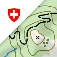
• Topomaps Canada (CanMatrix, seamless coverage at scales 1:50.000 and 1:250.000)
• Toporama Maps Canada in EN&FR (CanVec, NTDB, Atlas of Canada)
• Canada Basemap (CanVec, NTDB, Atlas of Canada)
• CanTopo (new Canada topos at 1:50.000, partial coverage of Can)
• Google Maps (Satellite images, Road- and Terrain-Map)
• Bing Maps (Satellite images, Road-Map)
• Open Street Maps (OSM Mapnik and Cloudemade Cyclemap)
• Hillshading overlay layer (NOT in this FREE version)
Toporama Maps Canada: These are the most recent topographic maps of Canada.
Topomaps Canada: These maps contain many small pathes and 4WD tracks that are missing in Toporama, Google, Bing and OSM maps. This layer is essential for real outdoor and offroad trips in Canada. Seamless mosaic of more than 13.000 collar clipped 1:50.000 maps.
LIMITATIONS OF THE FREE VERSION:
• Ads
• No Bulkdownload
• No Hillshading overlay
• Max. 3 Waypoints
• Max. 3 Tracks
• No Routes
• No import of waypoints and tracks
• No Local City DB (Offline Search)
Use this navigation app for outdoor activities like hiking, biking, camping, climbing, riding, skiing, canoeing or offroad 4WD tours.
Preload FREE map data for areas without cell service.
Canadian topographic maps are enhanced with Atlogis® hillshading and placenames.
Credits for topographic map data: "© Department of Natural Resources Canada. All rights reserved."
Please send comments and feature requests to [email protected]

Download and use topo maps offline to explore the outdoors using your...

Explore nature in a new way with the ultimate field guide and...

Download USGS topographic maps for offline use when no internet connection is...

Ever felt uneasy navigating on the water? Wanted to know your boat...

LandGlide® is the most advanced and comprehensive parcel data and property line...
On the road with the best app of the year: the swisstopo...
Frequently Asked Questions(FAQ)


Created with AppPage.net
Similar Apps - visible in preview.