
3Dsurvey Pilot
In-app purchases

3.4star
201 reviews
10K+
Downloads

Everyone
info

About this app
3Dsurvey Pilot transforms your regular consumer drone into accurate surveying and mapping tool. A free addition to 3Dsurvey photogrammetry software, 3Dsurvey Pilot is the perfect tool to plan your missions and automatically capture images along with GPS data.
Post-flight processing of captured images is done easily with 3Dsurvey photogrammetry software, generating highly accurate, metric and geo-referenced results, such as dense point cloud, 3D mesh, topography map, elevation model, DSM, orthophoto. Perfect for any surveying professional.
Currently, the app supports the following drones:
• DJI
- Phantom 4 Pro V2
- Phantom 4 Pro
- Phantom 4
- Phantom 3 Professional
- Phantom 3 Advanced
- Mavic Air
- Mavic Pro
- Mavic 2 Pro
- Inspire 1 (Pro)
- Inspire 2
- Spark
Features and benefits:
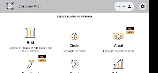
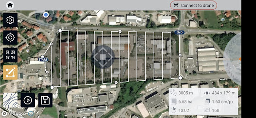
- Plan your mission - flight plans for different needs
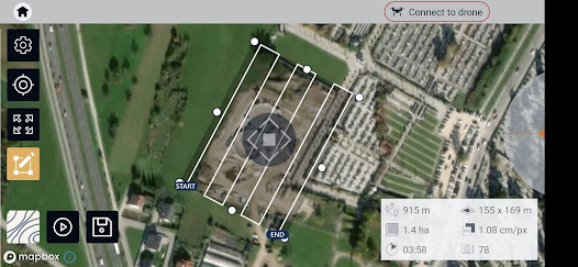
---GRID
Single Grid or Double Grid for mapping of rectangle areas - the fastest way for planning routes with simple settings
---POLYGON
Mapping of advanced/irregular shaped areas - additional area shapes and advanced settings
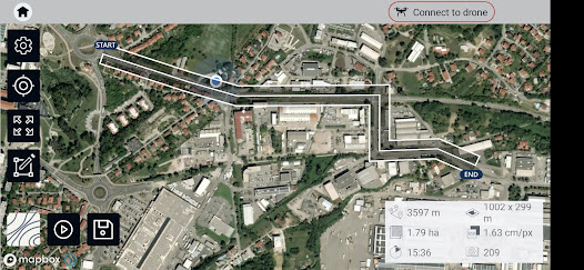
---ROAD
Developed specifically for simple and effective road, rail & corridor mapping
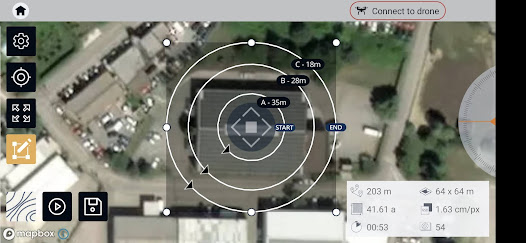
---CIRCLE
Circular mission for object mapping - always facing your point of interest for object 3D model reconstruction
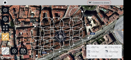
---URBANSCAN
Best mission for 3D model of large urban area
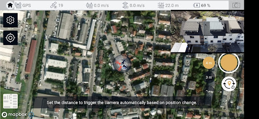
---FREE FLIGHT
Position or time based shutter trigger. Works also with Mavic mini 2 and Air 2s
---DOME
Flight on multiple heights for single 3D object
- Automated drone flight & image acquisition
- Telemetry and live camera feed during the mission
- Simple workflow with 3Dsurvey's processing software
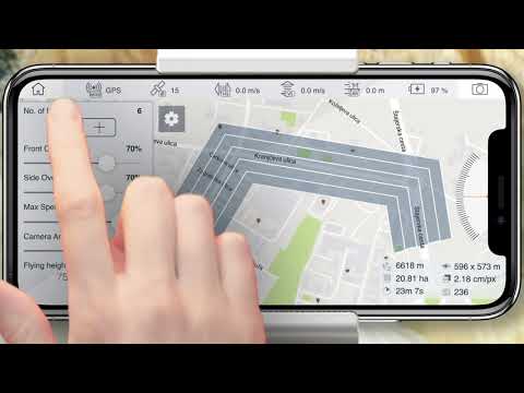
- Flight parameters for each mission - front & side image overlap, camera angle, flying height (AGL), flight speed - can be adjusted based on the requirements of the area and the project
- Advanced settings and options for demanding missions.
Post-flight processing & analysis using 3Dsurvey desktop software:
- Capture and recreate natural environment in digital form and survey from the office. Achieve high-resolution outputs with cm-grade accuracy.
- Use of Ground Control Points (GCPs) for improving the relative and absolute accuracy of the model
- Generate and modify:
--- Point clouds
--- Orthophotos
--- Digital 3D models (DSM, DTM, DEM)
--- CAD
--- Contour lines
--- Profiles and Cross sections
--- And more
- Measure:
--- Distances
--- Surfaces, Areas
--- Volumes
- Supports any drone & any camera/sensor. Works for aerial & terrestrial data acquisition methods. rTK- and EXIF GPS-ready for instant telemetry data import.
- 3Dsurvey is developed based on 300+ land surveying projects. Tailored to serve specific surveyors' needs. Cut fieldwork time by up to 100 times.
- Hybrid engine that utilizes both CPU and GPU for up to 15x faster image processing time. Large dataset support - 1000+ hi-res images.
- Compatible with third-party sources, data from LiDAR, Sonar, SLAM, terrestrial scanners. Seamless workflow for further combination with photogrammetric point clouds.
Usage information
Make sure you have the latest firmware installed and the app is up to date. The app follows the flight plan and does not avoid obstacles automatically.
3Dsurvey accepts no liability for damage, injuries or legalities from the misuse of this app. Use only in safe environments and follow your local drone regulation.
Post-flight processing of captured images is done easily with 3Dsurvey photogrammetry software, generating highly accurate, metric and geo-referenced results, such as dense point cloud, 3D mesh, topography map, elevation model, DSM, orthophoto. Perfect for any surveying professional.
Currently, the app supports the following drones:
• DJI
- Phantom 4 Pro V2
- Phantom 4 Pro
- Phantom 4
- Phantom 3 Professional
- Phantom 3 Advanced
- Mavic Air
- Mavic Pro
- Mavic 2 Pro
- Inspire 1 (Pro)
- Inspire 2
- Spark
Features and benefits:
- Plan your mission - flight plans for different needs
---GRID
Single Grid or Double Grid for mapping of rectangle areas - the fastest way for planning routes with simple settings
---POLYGON
Mapping of advanced/irregular shaped areas - additional area shapes and advanced settings
---ROAD
Developed specifically for simple and effective road, rail & corridor mapping
---CIRCLE
Circular mission for object mapping - always facing your point of interest for object 3D model reconstruction
---URBANSCAN
Best mission for 3D model of large urban area
---FREE FLIGHT
Position or time based shutter trigger. Works also with Mavic mini 2 and Air 2s
---DOME
Flight on multiple heights for single 3D object
- Automated drone flight & image acquisition
- Telemetry and live camera feed during the mission
- Simple workflow with 3Dsurvey's processing software
- Flight parameters for each mission - front & side image overlap, camera angle, flying height (AGL), flight speed - can be adjusted based on the requirements of the area and the project
- Advanced settings and options for demanding missions.
Post-flight processing & analysis using 3Dsurvey desktop software:
- Capture and recreate natural environment in digital form and survey from the office. Achieve high-resolution outputs with cm-grade accuracy.
- Use of Ground Control Points (GCPs) for improving the relative and absolute accuracy of the model
- Generate and modify:
--- Point clouds
--- Orthophotos
--- Digital 3D models (DSM, DTM, DEM)
--- CAD
--- Contour lines
--- Profiles and Cross sections
--- And more
- Measure:
--- Distances
--- Surfaces, Areas
--- Volumes
- Supports any drone & any camera/sensor. Works for aerial & terrestrial data acquisition methods. rTK- and EXIF GPS-ready for instant telemetry data import.
- 3Dsurvey is developed based on 300+ land surveying projects. Tailored to serve specific surveyors' needs. Cut fieldwork time by up to 100 times.
- Hybrid engine that utilizes both CPU and GPU for up to 15x faster image processing time. Large dataset support - 1000+ hi-res images.
- Compatible with third-party sources, data from LiDAR, Sonar, SLAM, terrestrial scanners. Seamless workflow for further combination with photogrammetric point clouds.
Usage information
Make sure you have the latest firmware installed and the app is up to date. The app follows the flight plan and does not avoid obstacles automatically.
3Dsurvey accepts no liability for damage, injuries or legalities from the misuse of this app. Use only in safe environments and follow your local drone regulation.
Updated on
Safety starts with understanding how developers collect and share your data. Data privacy and security practices may vary based on your use, region, and age. The developer provided this information and may update it over time.

No data shared with third parties
Learn more about how developers declare sharing

This app may collect these data types
App info and performance and Device or other IDs

Data is encrypted in transit

Data can’t be deleted
Ratings and reviews
3.4
195 reviews

Asigachi Luis
- Flag inappropriate
July 30, 2023
Guys, THis app is one of my go to apps when it comes to flight planning, however, on DJI Air 2s,, I have a special problem that just seems to be tied with this model. During the preflight check, one random thing doesnt check out. Sometimes its the camera, other times the P mode, other times everything checks out but it just fails to upload the mission. Please Check whats up with this model of drone.
4 people found this review helpful

Isaiah Mpofu
- Flag inappropriate
December 30, 2023
Worst mapping software. Maximum flight speed is 8ms and you can't change it. It also has a radius limit of 2km from home point. It's just too rigid as an app in comparison to apps like dji pilot.

Stephen
- Flag inappropriate
- Show review history
September 29, 2022
Seems to only want to work upside down on screen otherwise looks fine and a nice interface. Connects to M2EA via Smart Controller so seems compatible in that respect, except does not auto rotate to correct view.
1 person found this review helpful
3Dsurvey - Modri planet d.o.o.
September 29, 2022
We are sorry for the inconvenience.
Some devices have a notch, so we had to disable the auto-rotate option.
What's new
- fix for Road mission drone speed
- fix for showing signal lost message
- fix for showing big mission message on flight mode switch
- fix for mission time estimates
- fix for urban scan camera angle
- fix for showing signal lost message
- fix for showing big mission message on flight mode switch
- fix for mission time estimates
- fix for urban scan camera angle