
GPS Waypoints
Contains adsIn-app purchases
3.8star
1.4K reviews
100K+
Downloads

Everyone
info
About this app
Multi-purpose mapping and surveying tool for both professional and personal use. The tool is valuable in several professional land-based surveying activities, including agriculture, forest management, infrastructure maintenance (e.g. roads and electrical networks), urban planning & real estate and emergencies mapping. It is also used for personal outdoor activities, such as hiking, running, walking, travelling and geocaching.
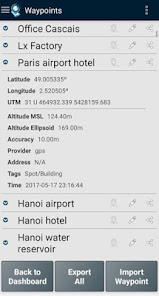
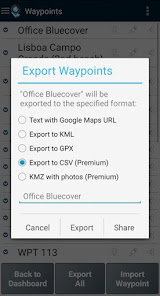
The application collects Points (such as points of interest) and Paths (sequence of points) to perform mapping and surveying activities. The Points, that are acquired with accuracy information, can be classified by the user with specific tags or characterized with photos. The Paths are created as a temporal sequence of newly acquired Points (e.g. to record a track) or alternatively with existing Points (e.g to create a route). Paths allows to measure distances and, if closed, forms Polygons that allows the determination of areas and perimeters. Both Points and Paths can be exported to a KML, GPX and CSV file and thus be processed externally with a geospatial tool.
The application uses the internal GPS receiver from the mobile device (typically with accuracies >3m) or, alternatively, allows professional users attaining better accuracies with a Bluetooth external GNSS receiver compatible with NMEA stream format (e.g. RTK receivers with centimeter level precision). See below some examples of the external receivers supported.
The application includes the following features:
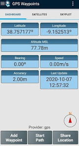
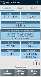
- Acquire current position with accuracy and navigation information;
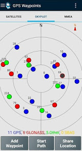
- Provide details of the active and visible satellites (GPS, GLONASS, GALILEO, BEIDOU and other);
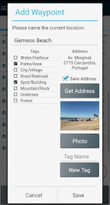
- Create Points with accuracy information, classify them with Tags, attach photos and convert coordinates into a human-readable address (reverse geocoding);
- Import Points from geographic coordinates (lat, long) or by searching for a street address/point of interest (geocoding);
- Create Paths by acquiring sequences of points manually or automatically;
- Import Paths from existing Points;
- Create survey's themes with custom Tags for classifing Points and Paths
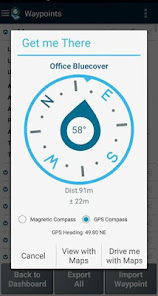
- Get directions and distances from current position to Points and Paths using a magnetic or gps compass;
- Export Points and Paths to KML and GPX file format;
- Share data with other applications (e.g. Dropbox/Google Drive);
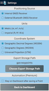
- Configure positioning source for the internal receiver or using an external receiver.
The Premium subscription include the following professional features:
- Backup and restore user's data (it also allows transfer data from one handset to another);
- Export Waypoints and Paths to CSV file format;
- Export Waypoints with photos to KMZ file
- Import multiple Points and Paths from CSV and GPX files;
- Sort and filter Points and Paths by creation time, name and proximity;
- Satellite signal analysis and interferences detection.
The Maps feature is an extra paid funcionality that allows selecting and visualizing your Points, Paths and Polygons on Open Street Maps.
Additionally to the internal mobile receiver, the current version is known to work with the following external receivers: Bad Elf GNSS Surveyor; Garmin Glo; Navilock BT-821G; Qstarz BT-Q818XT; Trimple R1; ublox F9P.
If you successfully tested the application with another external receiver please provide us your feedback as a user or manufacturer in order to extend this list.
For further information check our site (https://www.bluecover.pt/gps-waypoints) and get the details of our complete offer:
- Free and Premium features (https://www.bluecover.pt/gps-waypoints/features)
- GISUY Receivers (https://www.bluecover.pt/gisuy-gnss-receiver/)
- Enterprise (https://www.bluecover.pt/gps-waypoints/enterprise-version/)
The application collects Points (such as points of interest) and Paths (sequence of points) to perform mapping and surveying activities. The Points, that are acquired with accuracy information, can be classified by the user with specific tags or characterized with photos. The Paths are created as a temporal sequence of newly acquired Points (e.g. to record a track) or alternatively with existing Points (e.g to create a route). Paths allows to measure distances and, if closed, forms Polygons that allows the determination of areas and perimeters. Both Points and Paths can be exported to a KML, GPX and CSV file and thus be processed externally with a geospatial tool.
The application uses the internal GPS receiver from the mobile device (typically with accuracies >3m) or, alternatively, allows professional users attaining better accuracies with a Bluetooth external GNSS receiver compatible with NMEA stream format (e.g. RTK receivers with centimeter level precision). See below some examples of the external receivers supported.
The application includes the following features:
- Acquire current position with accuracy and navigation information;
- Provide details of the active and visible satellites (GPS, GLONASS, GALILEO, BEIDOU and other);
- Create Points with accuracy information, classify them with Tags, attach photos and convert coordinates into a human-readable address (reverse geocoding);
- Import Points from geographic coordinates (lat, long) or by searching for a street address/point of interest (geocoding);
- Create Paths by acquiring sequences of points manually or automatically;
- Import Paths from existing Points;
- Create survey's themes with custom Tags for classifing Points and Paths
- Get directions and distances from current position to Points and Paths using a magnetic or gps compass;
- Export Points and Paths to KML and GPX file format;
- Share data with other applications (e.g. Dropbox/Google Drive);
- Configure positioning source for the internal receiver or using an external receiver.
The Premium subscription include the following professional features:
- Backup and restore user's data (it also allows transfer data from one handset to another);
- Export Waypoints and Paths to CSV file format;
- Export Waypoints with photos to KMZ file
- Import multiple Points and Paths from CSV and GPX files;
- Sort and filter Points and Paths by creation time, name and proximity;
- Satellite signal analysis and interferences detection.
The Maps feature is an extra paid funcionality that allows selecting and visualizing your Points, Paths and Polygons on Open Street Maps.
Additionally to the internal mobile receiver, the current version is known to work with the following external receivers: Bad Elf GNSS Surveyor; Garmin Glo; Navilock BT-821G; Qstarz BT-Q818XT; Trimple R1; ublox F9P.
If you successfully tested the application with another external receiver please provide us your feedback as a user or manufacturer in order to extend this list.
For further information check our site (https://www.bluecover.pt/gps-waypoints) and get the details of our complete offer:
- Free and Premium features (https://www.bluecover.pt/gps-waypoints/features)
- GISUY Receivers (https://www.bluecover.pt/gisuy-gnss-receiver/)
- Enterprise (https://www.bluecover.pt/gps-waypoints/enterprise-version/)
Updated on
Safety starts with understanding how developers collect and share your data. Data privacy and security practices may vary based on your use, region, and age. The developer provided this information and may update it over time.

No data shared with third parties
Learn more about how developers declare sharing

No data collected
Learn more about how developers declare collection
Ratings and reviews
3.8
1.36K reviews

Doug Jensen
- Flag inappropriate
May 10, 2022
Wonderful app for collecting waypoints but automatic path capture stops or is interrupted for unknown reasons. I'm using the non-premium version of the app to test but before purchase I'd like some assurance the problems will go away with ownership (perhaps due to ad interruption of path capture.) I use this app to track aquatic invasive plant species. I use manual waypoint capture to mark specific points but also rely on automatic path capture while kayaking around areas (when I can't use my hands). I capture points at 10 second or longer intervals for a period of an hour or more. What I find is the path starts fine but then stops capturing points at seemingly random intervals after starting the path. It seems the phone sleeping or an ad or another app (I don't know what) stops or stalls capture of a path. For example, after starting an automatic path capture, I get clean points taken for a while (every 10 seconds for example) then the points seem to pause - and then starts again after a while. This may or may not be correlated to when I wake the phone to access a text message or other app. In one experiment if I kept the app 'active' all the time by holding the phone and keeping the screen active continuously, capture is flawless, but problems occur when I put it back in my pocket and (I assume) things start to go to sleep. My phone is in 'optimized' power usage mode, and I have added GPS Waypoints to the list of "apps that won't be put to sleep' under power management. None of these fixes has changed the app behavior. Help me resolve these, as this app is exactly what I've been looking for. Thank you!
51 people found this review helpful
Bluecover Technologies
May 10, 2022
Thank you for your feedback. The location timeout service is set by default to 10 seconds. You can update it in Premium for having longer path recordings in background. Check our online manual.

Stan Frericks
- Flag inappropriate
February 21, 2023
I got the premium for no adds which is great .also the premium maps I might of made a mistake doing this because before I could get the Google earth view and I like that better than showing me a map if I can't get that Back I'm going to see if I can cancel the premium map part even if I don't get reimbursed and have to pay For it. There might be a way to get the old for mat back But don't know how. I could use a little help. The GPS way points are right on.
49 people found this review helpful
Bluecover Technologies
February 21, 2023
Thank you for the feedback. It is true we have a button on Points to call Google Maps in regular version. Nonetheless, G Maps does not exist in all devices, G Maps do not support Paths, and we are not sure if this G Maps interface we will have supported continuity. Even so, if you like the button, we can add it in parallel with our Maps button.

Terry Richardson
- Flag inappropriate
December 30, 2021
I use this is my 400-level Aquatic Ecology class. Students use GPS Waypoints to map lakes, ponds, and wetlands. The students, as well as myself, love the ease of use and accuracy. Indeed, it's waypoint accuracy is often better than with expensive handheld GPS units when we've used ground-truthing. My students and me are anxiously awaiting an iPhone version so ALL my students can use GPS Waypoint. Keep up the good work guys!
39 people found this review helpful
What's new
Version 3.12
- Maps with Manage Layers
- Maps with Add WMS service improvement
- Some fixes (shortkeys, Path kml export)
Version 3.11
- Export/Import Points and Paths to GeoJSON files
- New coordinate format with decimal minutes (DDM)
- Tags improvements (incluing navigation swipe)
- Edit current Theme, manage local Themes, get remote Themes per sectors


