Locus GIS offline land survey
In-app purchases
3.9star
1.47K reviews
500K+
Downloads

Everyone
info


About this app
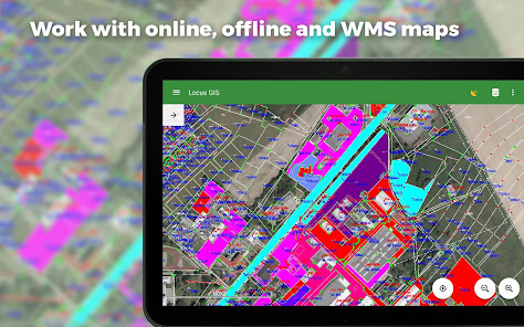
Professional GIS application for offline fieldwork with geodata. It provides data collection, viewing, and updating. All its features are available above a wide selection of online, offline, and WMS maps.
Fieldwork
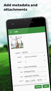
• offline collecting and updating of field data
• saving points with current or arbitrary position
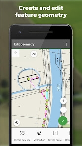
• creating lines and polygons by motion recording
• settings of attributes
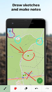
• photos, video/audio or drawings as attachments
• guidance to points
• collecting location data for polygon/line recording or guidance on a target, even when the app is running in the background
Import/Export
• importing and editing ESRI SHP files
• exporting data to ESRI SHP or CSV files
• exporting whole projects to QGIS
Maps
• wide range of maps both for online use and for download
• support of WMS sources
• support of offline maps in MBTiles, SQLite, MapsForge, TAR, GEMF, RMAP formats, and custom OpenStreetMap data or map themes
Tools and features
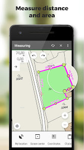
• measuring distances and areas
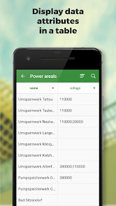
• searching and filtering of data in the attribute table
• style editing and text labels
• organizing data into layers and projects
Locus GIS is successfully used in a wide range of industries:
• collection of environmental data (ecological scanning, tree surveys ...)
• forestry management and planning,
• agriculture and soil management
• gas and energy distribution
• planning and construction of wind farms
• exploration of mining fields and location of wells
• survey and management of urban facilities
• road constructions and maintenance
Fieldwork
• offline collecting and updating of field data
• saving points with current or arbitrary position
• creating lines and polygons by motion recording
• settings of attributes
• photos, video/audio or drawings as attachments
• guidance to points
• collecting location data for polygon/line recording or guidance on a target, even when the app is running in the background
Import/Export
• importing and editing ESRI SHP files
• exporting data to ESRI SHP or CSV files
• exporting whole projects to QGIS
Maps
• wide range of maps both for online use and for download
• support of WMS sources
• support of offline maps in MBTiles, SQLite, MapsForge, TAR, GEMF, RMAP formats, and custom OpenStreetMap data or map themes
Tools and features
• measuring distances and areas
• searching and filtering of data in the attribute table
• style editing and text labels
• organizing data into layers and projects
Locus GIS is successfully used in a wide range of industries:
• collection of environmental data (ecological scanning, tree surveys ...)
• forestry management and planning,
• agriculture and soil management
• gas and energy distribution
• planning and construction of wind farms
• exploration of mining fields and location of wells
• survey and management of urban facilities
• road constructions and maintenance
Updated on
Safety starts with understanding how developers collect and share your data. Data privacy and security practices may vary based on your use, region, and age. The developer provided this information and may update it over time.

No data shared with third parties
Learn more about how developers declare sharing

This app may collect these data types
Personal info, Financial info and 2 others

Data is encrypted in transit

You can request that data be deleted
Ratings and reviews
3.9
1.39K reviews

john grods
- Flag inappropriate
November 29, 2023
I have been doing mapping for several decades now. This is by far the greastest little app I have added to my toolbelt in a long time. Took a bit of time to figure out the processes, a manual to view offline would have been helpful. Looking forward to other upgrades and integrations.
17 people found this review helpful
Asamm Software, s. r. o.
January 3, 2024
Thank you for the review. At the moment only the online manual is available (doc page). Anyway, please feel free to contact us with any questions or problems.

A Google user
- Flag inappropriate
- Show review history
March 2, 2020
An excellent tool for any sort of field work which requires recording spatial data. Very easy to use and very powerful. Points, Lines and Shapes can be added in separate layers on top of your chosen base map in a variety of colours and styles. It is possible to define a list of attributes (like a form) for the individual points/lines/shapes within each layer. This allows the user to record a whole host of user-defined data about each spatial location as well as attaching multiple photos, videos and sketches to each point. Import/Export tools to external GIS programs allow the data to the consolidated and manipulated centrally. The free version comes with full functionality but with a limit of 2 map layers and 3 data layers, whereas the subscription version removes the limit on the number of layers.
122 people found this review helpful
Asamm Software, s. r. o.
March 5, 2020
Thank you very much for your ultimate review!!!
A Google user
- Flag inappropriate
- Show review history
March 24, 2020
Such a great apps as it really assist my teammates and I in making data collection which in spatial, attributes and can also be attached with pictures. The developers also really responsive and helpful in giving the solutions of my problem by updating this apps into the latest version. I really enjoy using this apps and very recommended to be used especially for information that related to GIS. Thank you so much😀
44 people found this review helpful
Asamm Software, s. r. o.
March 25, 2020
Thank you for your reply. We're glad that you're satisfied with the app.
What's new
*** 1.22.2 ***
- add: a brand-new manager for GNSS external devices
- add: NTRIP client (currently in beta testing)
- add: ability to choose multiple options for enumeration attributes
- add: a completely new system for managing accuracy tolerances and warnings
- add: edit the starting number in the auto-numbering sequence
- add: option to add several independent WMS layers from a single WMS service


