
MGRS UTM GPS
Contains adsIn-app purchases
4.6star
1.2K reviewsinfo
100K+
Downloads

PEGI 3
info


About this app
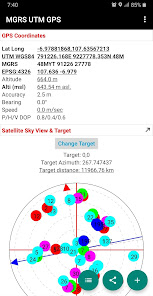
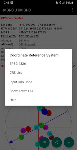
Simple scientific offline GPS application for Surveyors, Military, Orienteering and other outdoor activities with Latitude Longitude, UTM, MGRS and other Coordinate Reference System in the World (using EPSG Codes, You can find the codes for most commonly used map projections at www.spatialreference.org).
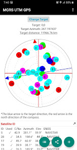
Additional information include GPS altitude (Ellipsoid), MSL altitude (EGM96), accuracy, speed, bearing and GPS Sky View complete with information about satellite name, satellite location (azimuth & elevation angle) etc..
Free Features:
- Getting GPS coordinates from most commonly used map projections / Coordinate Reference System in the World.
- Share or save unlimited measure data inside your database.
- Change altitude units (meter, feet).
- Change Latitude Longitude display format (decimal degrees, DMS)
- Change UTM display format (UTM with band letter, UTM with north/south hemisphere)
- Change speed units (m/sec, km/h, mi/h, knots)
- Add photo to your data.
- Labelling: edit notes / label on each observation data.
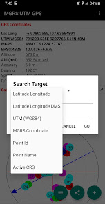
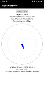
- Searching point / coordinate using compass.
- Export data to CSV, KML, GPX and DXF file.
- Calculate Area and Distance.
Premium Features:
- No Ads.
Additional information include GPS altitude (Ellipsoid), MSL altitude (EGM96), accuracy, speed, bearing and GPS Sky View complete with information about satellite name, satellite location (azimuth & elevation angle) etc..
Free Features:
- Getting GPS coordinates from most commonly used map projections / Coordinate Reference System in the World.
- Share or save unlimited measure data inside your database.
- Change altitude units (meter, feet).
- Change Latitude Longitude display format (decimal degrees, DMS)
- Change UTM display format (UTM with band letter, UTM with north/south hemisphere)
- Change speed units (m/sec, km/h, mi/h, knots)
- Add photo to your data.
- Labelling: edit notes / label on each observation data.
- Searching point / coordinate using compass.
- Export data to CSV, KML, GPX and DXF file.
- Calculate Area and Distance.
Premium Features:
- No Ads.
Updated on
Safety starts with understanding how developers collect and share your data. Data privacy and security practices may vary based on your use, region, and age. The developer provided this information and may update it over time.

This app may share these data types with third parties
Location, App activity, and Device or other IDs

No data collected
Learn more about how developers declare collection

Data is encrypted in transit

Data can’t be deleted
Ratings and reviews
4.6
1.17K reviews

Wilfred Aliguma
- Flag inappropriate
- Show review history
March 21, 2024
Thanks innovators for designing and always responding to our concerns. This app is really good well being the best among similar ones. What is remaining now to improve on accuracy. Before it couldn't go below 3.9m but as per now it can reach 3.0m. best accuracy should be 0 - 1m. What is needed is coloring of accuracy red to green when recommendable accuracy is recorded and alert alarm. I wish you the best
7 people found this review helpful
Y2 Tech
August 20, 2022
Thank you for your feedback, we will take it as consideration.

nick name
- Flag inappropriate
November 11, 2020
it's a good application to share a geographic location by a variety of coordinate projections. it's good to have it when you're lost, and can share your location only over SMS but not over any internet app. the 5th star is missing, since the app menus are too dark, so they aren't visible in clear sun. i promise to give you the five stars when you fix it.
65 people found this review helpful

A Google user
- Flag inappropriate
April 1, 2020
Using this to record invasive plant species. I like the simultaneus lat-long utm displays. Easy to save and share even with the free version.
36 people found this review helpful
Y2 Tech
April 2, 2020
Glad to hear this, thank you.
What's new
Add more improvements.


