World Atlas MxGeo Pro
4.6star
612 reviewsinfo
10K+
Downloads
Teacher Approved

PEGI 3
info

About this app
World atlas, world map and educational app for geography. Offers more than 260 countries and territories of the world with comprehensive economic and geopolitical data. Political maps with regional units (provinces), capitals and major cities included.
Designed for smartphones and tablets.
• Maps, flags and comprehensive data for more than 260 countries and territories of the world
• Search for countries, major cities, rivers and mountains or coordinates
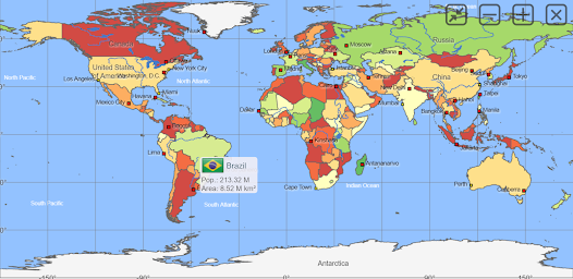
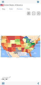
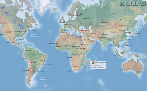
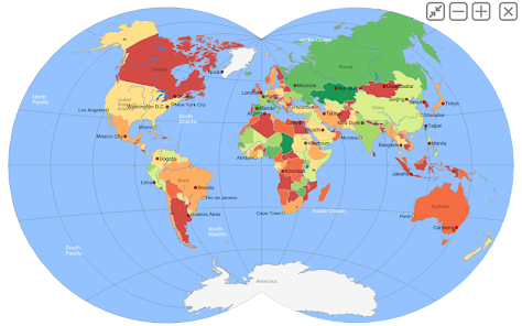
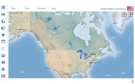
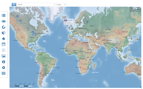
• Interactive political world, continent and country maps
• Shaded relief layer for world and continent maps
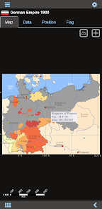
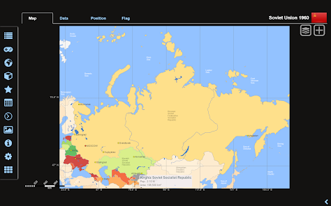
• Historical political world and continent maps of 1900 and 1960
• Geography quiz challenge for playful learning
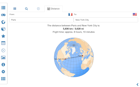
• Country comparison, favorites and distance calculator
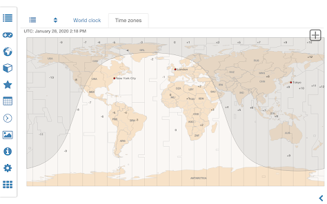
• World clock with time zone display
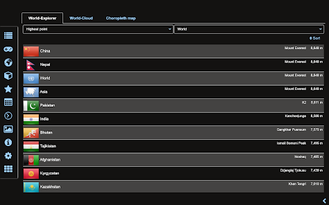
• World-explorer: the smallest, largest, wealthiest, and most populated countries of the world
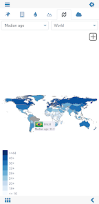
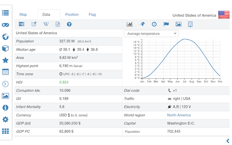
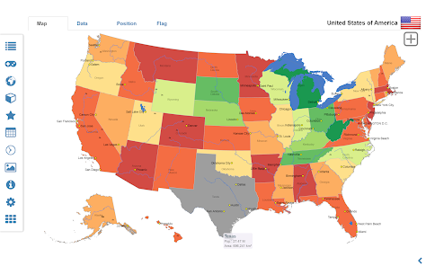
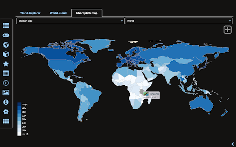
• Choropleth maps: temperature, area, HDI, population, ...
• No online connection required
• No advertising or In App Purchases
• No permissions required
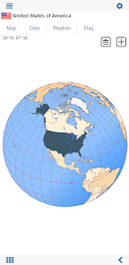
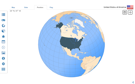
Explore the world through political continent and country offline maps. Whether Europe, Africa, Asia, Oceania, South and North America: maps of all continents and countries are included. Learn where each country in the world is located. View its position highlighted on a digital globe. Create your favorite color theme or choose from different color schemes for map display.
Do you know the flag of Mauritius? Yes? Perfect. Do you also know in which country Mount Everest is located?
“World atlas & world map MxGeo Pro” Quiz helps you acquire a geographic literacy in a playful manner.
Choose from seven geo guessing games:
• Test your knowledge about the capitals in the world
• Guess the Federal states for selected countries (USA, Germany, Brazil,..)
• Recognize the proper country flag based on the outline map
• Do you know the top-level domains of the world's countries?
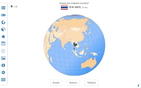
• Guess the highlighted country on the virtual globe
• Guess the right country by the flag
• Do you know the ISO countries codes of the world?
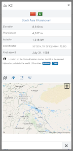
• Do you know the mountains of the world?
Each quiz offers seven regional variants: World, Europe, Africa, Asia, Oceania, South or North America.
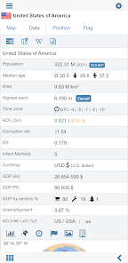
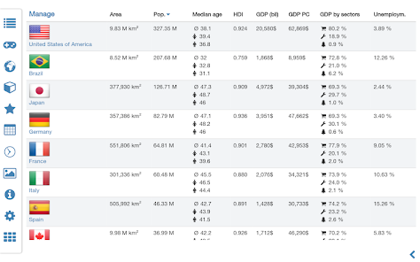
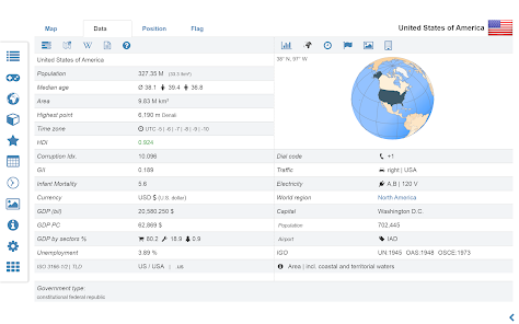
Geo learning app and educational game which is fun for everyone whether children, adults, seniors or teachers. Get ready for your next stay abroad while enjoying this great world almanac including time zones and statistical data, such as population growth, unemployment rate, average age, gross domestic product (GDP) by sector and other key figures. Or prepare for your next geography lesson with this genius digital world map. If not traveling our world atlas lets you explore the world just only virtually.
Enjoy the comprehensive atlas of the World including Europe, Asia, North America, Africa, Oceania and South America with all countries and regional units, capitals and flags.
Designed for smartphones and tablets.
• Maps, flags and comprehensive data for more than 260 countries and territories of the world
• Search for countries, major cities, rivers and mountains or coordinates
• Interactive political world, continent and country maps
• Shaded relief layer for world and continent maps
• Historical political world and continent maps of 1900 and 1960
• Geography quiz challenge for playful learning
• Country comparison, favorites and distance calculator
• World clock with time zone display
• World-explorer: the smallest, largest, wealthiest, and most populated countries of the world
• Choropleth maps: temperature, area, HDI, population, ...
• No online connection required
• No advertising or In App Purchases
• No permissions required
Explore the world through political continent and country offline maps. Whether Europe, Africa, Asia, Oceania, South and North America: maps of all continents and countries are included. Learn where each country in the world is located. View its position highlighted on a digital globe. Create your favorite color theme or choose from different color schemes for map display.
Do you know the flag of Mauritius? Yes? Perfect. Do you also know in which country Mount Everest is located?
“World atlas & world map MxGeo Pro” Quiz helps you acquire a geographic literacy in a playful manner.
Choose from seven geo guessing games:
• Test your knowledge about the capitals in the world
• Guess the Federal states for selected countries (USA, Germany, Brazil,..)
• Recognize the proper country flag based on the outline map
• Do you know the top-level domains of the world's countries?
• Guess the highlighted country on the virtual globe
• Guess the right country by the flag
• Do you know the ISO countries codes of the world?
• Do you know the mountains of the world?
Each quiz offers seven regional variants: World, Europe, Africa, Asia, Oceania, South or North America.
Geo learning app and educational game which is fun for everyone whether children, adults, seniors or teachers. Get ready for your next stay abroad while enjoying this great world almanac including time zones and statistical data, such as population growth, unemployment rate, average age, gross domestic product (GDP) by sector and other key figures. Or prepare for your next geography lesson with this genius digital world map. If not traveling our world atlas lets you explore the world just only virtually.
Enjoy the comprehensive atlas of the World including Europe, Asia, North America, Africa, Oceania and South America with all countries and regional units, capitals and flags.
Updated on
Safety starts with understanding how developers collect and share your data. Data privacy and security practices may vary based on your use, region, and age. The developer provided this information and may update it over time.

No data shared with third parties
Learn more about how developers declare sharing

No data collected
Learn more about how developers declare collection

Committed to follow the Play Families Policy
Ratings and reviews
4.6
518 reviews

Robert Charlesworth
- Flag inappropriate
September 6, 2020
Disappointing level of detail. Nothing much visible at county level in the USA (or Oblast level in the Ukraine for instance), even if you click on a county to zoom in (you then lose the context anyway). Also search function sometimes misses major cities and even regions. I'm giving it two stars because it actually works, but it didn't do what I wanted, so was a waste of money. For kids or casual use I suppose it's OK, but it isn't a serious atlas, the kind you can buy in a book store.
53 people found this review helpful

Terminus 844
- Flag inappropriate
June 13, 2022
Have been using the free version for a little over a year and found it to be very nicely done. Having recently upgraded to the pro version, I find that I like the app even better. If you are mainly interested in basic world geography then the free version is great, but the wealth of additional info provided by pro makes it totally worthwhile for those seeking more comprehensive knowledge.
34 people found this review helpful

Uthman Muhajab
- Flag inappropriate
August 5, 2021
The app is well set-up and well informative 🤜🤛. Though, needs a little bit touch improvements on some countries database is seemed to be too old and some map of the countries are not proportional on their sizes on the map; for instance when you compare Germany and Sweden you might think Germany in the map smaller but infect it is bigger than Sweden.
17 people found this review helpful
HPB Labs
August 27, 2021
Hi, thanks for sharing your experience with the app. We are always improving the app and are happy for any suggestions. In the mean time we recommend to use the zoomable position view (globe) we provide for all countries to shows the area proportions. As well as the "Natural Earth" projection for the world map will do.
Kind regards
MxGeo Support
What's new
• Updates for maps and data
• Bug fixes and improvements
• Improved river search in map view
8.x:
• Population density choropleth maps for federal states
• Print maps and country data
• Enhanced chart visualization
• New key indicators: population density, Gini coefficient
• Historical world and continent maps of 1900, 1930 and 1960
• Search for countries, major cities, rivers, mountains, islands, lakes and coordinates
• World Explorer: largest cities, longest rivers and highest mountains


