Biosphärenreservat Rhön
4.4star
24 reviewsinfo
5K+
Downloads

USK: All ages
info


About this app
Biosphere reserve in 3D
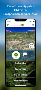
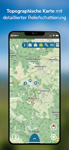
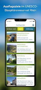
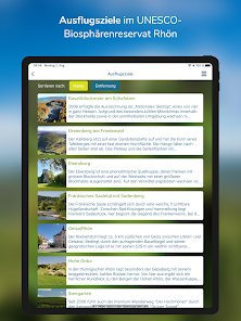
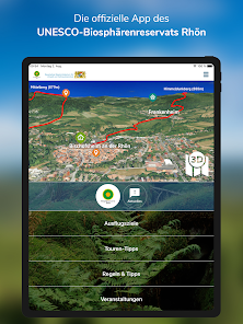
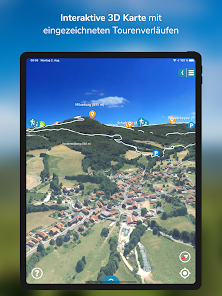
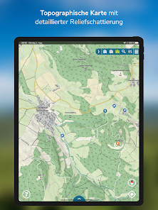
Hiking and cycling, finding out about species and nature conservation and enjoying regional products: the UNESCO Rhön Biosphere Reserve is full of treasures to be discovered. The new 3D app is the ideal personal assistant for this. The unique landscape with its diverse bike and hiking trails is shown as it really is. All important geographic information is incorporated into the map. With an exact location function, your own position can be checked at any time. A change between 3D map, topographic map and aerial photo is possible at any time.
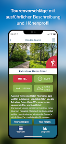
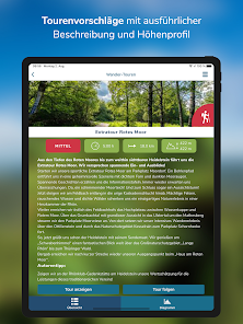
And so the Rhön, the "Land of Open Afar", with its numerous tourist lighthouses such as Wasserkuppe, Kreuzberg, Schwarzes and Rotes Moor or Point Alpha becomes a virtual experience even before the start. These can then be experienced on site, e.g. on the premium hiking trail "DER HOCHRHÖNER" and the numerous extra tours. The experience of the Rhön nature is deepened by information and adventure offers that convey the goals of the UNESCO biosphere reserve.
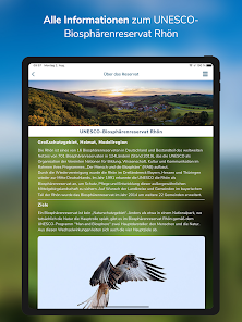
In addition, there is a lot of exciting information about the wild nature as well as webcams that offer up-to-date images.
A great function for a tour experience in virtual reality is the "Virtual Panorama": Here a 360 ° panorama can be viewed from any location, enriched with additional information such as mountain names and heights or points of interest such as restaurants - give it a try !
And if you want to follow your route: with the built-in tracking tool, users can record their own tours. On the way on the tour, if the function is switched on, your own position, the distance covered, the duration of the tour and the current altitude meters are displayed with pinpoint accuracy. Photos can also be saved via “My Tour” and stored in a personal tour book. The tracking function facilitates orientation in the national park.
Whether a guided tour of the star park with a certified star guide, a guided tour with the ranger in the Red Moor or a relaxed open-air event with brass music - the biosphere app provides a fascinating educational and adventure program - and there is something for every taste. The visitor can find out about the offers before his visit and register with the organizer in good time.
Important NOTE
Since there is no area-wide mobile phone connection in the Rhön Biosphere Reserve, the app was also created for offline mode. Downloading the map leads to increased data volumes. We therefore recommend downloading one or both parts of the national park map via WLAN.
Hiking and cycling, finding out about species and nature conservation and enjoying regional products: the UNESCO Rhön Biosphere Reserve is full of treasures to be discovered. The new 3D app is the ideal personal assistant for this. The unique landscape with its diverse bike and hiking trails is shown as it really is. All important geographic information is incorporated into the map. With an exact location function, your own position can be checked at any time. A change between 3D map, topographic map and aerial photo is possible at any time.
And so the Rhön, the "Land of Open Afar", with its numerous tourist lighthouses such as Wasserkuppe, Kreuzberg, Schwarzes and Rotes Moor or Point Alpha becomes a virtual experience even before the start. These can then be experienced on site, e.g. on the premium hiking trail "DER HOCHRHÖNER" and the numerous extra tours. The experience of the Rhön nature is deepened by information and adventure offers that convey the goals of the UNESCO biosphere reserve.
In addition, there is a lot of exciting information about the wild nature as well as webcams that offer up-to-date images.
A great function for a tour experience in virtual reality is the "Virtual Panorama": Here a 360 ° panorama can be viewed from any location, enriched with additional information such as mountain names and heights or points of interest such as restaurants - give it a try !
And if you want to follow your route: with the built-in tracking tool, users can record their own tours. On the way on the tour, if the function is switched on, your own position, the distance covered, the duration of the tour and the current altitude meters are displayed with pinpoint accuracy. Photos can also be saved via “My Tour” and stored in a personal tour book. The tracking function facilitates orientation in the national park.
Whether a guided tour of the star park with a certified star guide, a guided tour with the ranger in the Red Moor or a relaxed open-air event with brass music - the biosphere app provides a fascinating educational and adventure program - and there is something for every taste. The visitor can find out about the offers before his visit and register with the organizer in good time.
Important NOTE
Since there is no area-wide mobile phone connection in the Rhön Biosphere Reserve, the app was also created for offline mode. Downloading the map leads to increased data volumes. We therefore recommend downloading one or both parts of the national park map via WLAN.
Updated on
Safety starts with understanding how developers collect and share your data. Data privacy and security practices may vary based on your use, region, and age. The developer provided this information and may update it over time.


Ratings and reviews
4.3
22 reviews
What's new
Sommerupdate 2023


