
AFTrack - GPS Tracking
4.9star
70 reviewsinfo
1K+
Downloads

USK: All ages
info


About this app
AFTrack is the display for your GPS and activates the world of hiking, biking, sailing, geocaching or more for your phone. The program handles tracking with smart and fixed logging features. If needed it sends reports online. It exports tracks and waypoints. Uses maps online and offline and more.
Features
GPS and other input
- different sources: internal gps, internal with NMEA, bluetooth gps, USB gps, online gps over Wifi/4G, NMEA file
- read NMEA, GpsD json, Signal K json
- work as gps daemon (nmea or json, port 2947 only)
- connection with AIS server (NMEA format)
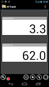
- altitude correction (automatic or manual) and Kalman filter
- pressure usable for altitude (if available)
- pressure start altitude editable
- automatic correction over weather server (needs net connection)
- wind data from SailTimer™ wind cloud (needs SailTimer API™)
Tracking
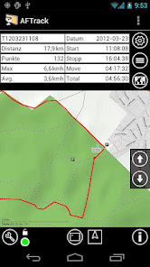
- collect track data local database
- show routes or tracks in up/down hill colors
- export tracks to GPX, KML, OVL, IGC format and send or upload it
- import route data - GPX, TCX or KML format
- import, export way points - GPX or KML format
- import areas from KML format
- use a kml.txt format to send exports direct via bluetooth
- design a route or an area on the map
- design a route using BRouter offline data, with inland waterway
- design a route using wind information and polar data
- edit a route or an area on the map
- merge some routes
- copy way points to route
- get new way point from bearing, map or position
- add predefined way point collection to map
- revers routes
- Routing in a corridor
- off road routing along the line
Maps
- online maps - pool editable, tile or WMS based
- offline maps - OSM mapsforge vector format
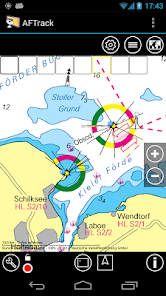
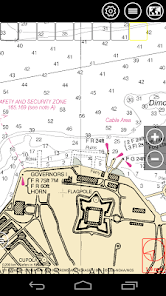
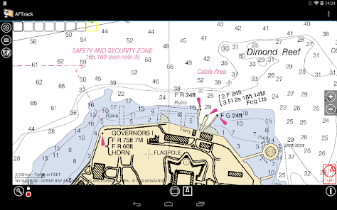
- offline maps - BSB3 format for marine navigation
- offline maps - NV digital for marine navigation
- offline maps - Navionics Charts
- offline maps - OSZ format build by MobileAtlasCreator
- offline maps - SQLite formats mbtiles and sqlitedb build by MobileAtlasCreator and/or Maperitive
- offline maps - mph/mpr format
- offline maps - GeoTiff (partly)
- use offline maps from jpg, png or bmp files
- use offline maps with calibration file map, gmi, kml, kal, cal, pwm, tfw or jpr format
- make own calibration for a bitmap
- seamless maps display when using OSZ or SQLite tile container
- map selector to have quick access to available offline maps
- map scan for a defined folder and sub folder
- map overlays - online pool editable
- map offline overlays - in mbtiles 'overlay' format
- scaling charts 2x/4x
View
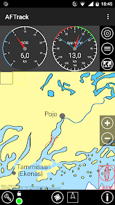
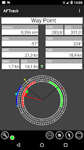
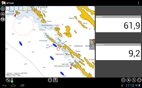
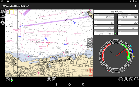
- wind indicator for the map or position center
- display depth - if available
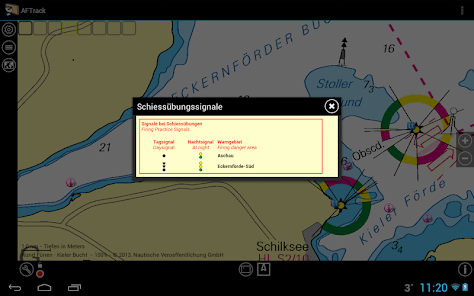
- display AIS information - if available
- display ADS-B (air plane) information - if available
- vario display
- vario sound
- alarm on reached POIs
- set anchor alarm for the current position
- set anchor alarm for a way point that receives positions from a gps tracker
- save and restore settings
- send waypoint or anchor alarm to Android Wear
Online
- Online position sending for live tracking
- Online receive way point positions from a GpsGate server
- convert received way point history to track
- getting way point positions from a GpsGate server
There are some plugins to fix special needs. Please search for AFTrack plugin.
Please send remarks to afischer@dbserv.de
Features
GPS and other input
- different sources: internal gps, internal with NMEA, bluetooth gps, USB gps, online gps over Wifi/4G, NMEA file
- read NMEA, GpsD json, Signal K json
- work as gps daemon (nmea or json, port 2947 only)
- connection with AIS server (NMEA format)
- altitude correction (automatic or manual) and Kalman filter
- pressure usable for altitude (if available)
- pressure start altitude editable
- automatic correction over weather server (needs net connection)
- wind data from SailTimer™ wind cloud (needs SailTimer API™)
Tracking
- collect track data local database
- show routes or tracks in up/down hill colors
- export tracks to GPX, KML, OVL, IGC format and send or upload it
- import route data - GPX, TCX or KML format
- import, export way points - GPX or KML format
- import areas from KML format
- use a kml.txt format to send exports direct via bluetooth
- design a route or an area on the map
- design a route using BRouter offline data, with inland waterway
- design a route using wind information and polar data
- edit a route or an area on the map
- merge some routes
- copy way points to route
- get new way point from bearing, map or position
- add predefined way point collection to map
- revers routes
- Routing in a corridor
- off road routing along the line
Maps
- online maps - pool editable, tile or WMS based
- offline maps - OSM mapsforge vector format
- offline maps - BSB3 format for marine navigation
- offline maps - NV digital for marine navigation
- offline maps - Navionics Charts
- offline maps - OSZ format build by MobileAtlasCreator
- offline maps - SQLite formats mbtiles and sqlitedb build by MobileAtlasCreator and/or Maperitive
- offline maps - mph/mpr format
- offline maps - GeoTiff (partly)
- use offline maps from jpg, png or bmp files
- use offline maps with calibration file map, gmi, kml, kal, cal, pwm, tfw or jpr format
- make own calibration for a bitmap
- seamless maps display when using OSZ or SQLite tile container
- map selector to have quick access to available offline maps
- map scan for a defined folder and sub folder
- map overlays - online pool editable
- map offline overlays - in mbtiles 'overlay' format
- scaling charts 2x/4x
View
- wind indicator for the map or position center
- display depth - if available
- display AIS information - if available
- display ADS-B (air plane) information - if available
- vario display
- vario sound
- alarm on reached POIs
- set anchor alarm for the current position
- set anchor alarm for a way point that receives positions from a gps tracker
- save and restore settings
- send waypoint or anchor alarm to Android Wear
Online
- Online position sending for live tracking
- Online receive way point positions from a GpsGate server
- convert received way point history to track
- getting way point positions from a GpsGate server
There are some plugins to fix special needs. Please search for AFTrack plugin.
Please send remarks to afischer@dbserv.de
Updated on
Safety starts with understanding how developers collect and share your data. Data privacy and security practices may vary based on your use, region, and age. The developer provided this information and may update it over time.

No data shared with third parties
Learn more about how developers declare sharing

No data collected
Learn more about how developers declare collection

Data is encrypted in transit

Data can’t be deleted
Ratings and reviews
4.8
59 reviews

Robin
- Flag inappropriate
- Show review history
May 2, 2020
Update May 2020 : So fantastic!! Not polished-looking but FUNCTONAL and CAPABLE. *************! i wanted something to create a track of my walks, rides, and kayak trips. This did it without a learning curve. Yay background maps! All extents!
11 people found this review helpful

Guido
- Flag inappropriate
December 18, 2022
Wow no reviews? I used this on my Nokia N70 with an external bluetooth GPS _a lot_ for Geoaching by bycicle back in the days. This Android version is pretty much the same excellent quality! Thank you! :)

A Google user
- Flag inappropriate
December 23, 2014
Best app to record tracks with barometer altitude for better precision.
17 people found this review helpful
What's new
New routing tiles Download dialog
Moved routing folders to public (media/...)
New Permission dialog
Moved routing folders to public (media/...)
New Permission dialog


