

vTools Survey Pro - GIS Expert

5.0star
24 reviews
100+
Downloads

Rated for 3+
info


About this app
The application makes mapping, management planning and field inspection simple, fast and convenient.
Fully integrated with the same functions as a handheld GPS and also adds many new functions to turn your phone into a powerful tool to support field survey and planning. Field management is the easiest.
The main functions of the application:
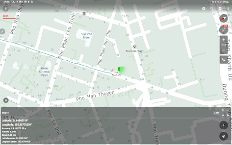
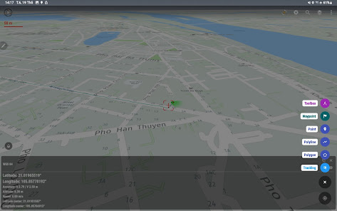
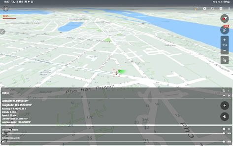
- Positioning, current position, practical view angle in the field. Help identify better directions.
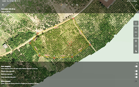
- Allows users to directly create objects (Points, Lines, Polygons, Coordinate Waypoints, Tracklog routes).
- Allows rapid measurement of the area and length of objects in the field.
- Users can simultaneously create Tracklog, Point, Line, and Polygon at the same time while moving. Tracklog mode allows running in the background.
- Support to save attribute information and images in the field.
- Users can define attribute fields to collect. And share quickly to the whole group via QR code or export to file.
- Find for waypoint, enter a list of waypoints from data TEXT(*.txt), Excel (*.xls, *.xlsx), CSV (*.csv) Excel and convert point coordinates directly on the device.
- Allow to enter the list of points to check by hand (For example, it is necessary to check the location of the extract of the red book).
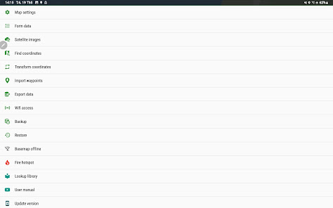
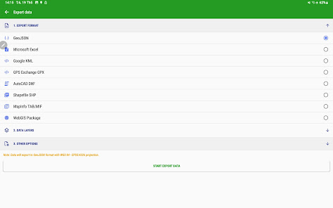
- Support directly opening common data such as Excel, GPS/GPX, KML/KMZ, GeoJSON, AutoCAD DXF, MicroStation DGN, ESRI Shapefile SHP, MapInfo TAB, gCadas GTP, GeoTIFF, JPG, PNG
- Support export data to GPX, KML, GeoJSON, Excel, AutoCAD DXF, MapInfo TAB, Shapefile SHP format and share via Email, Drive, Zalo, Facebook etc.
- Fully support the VN 2000 projection system of the local and nationwide of Vietnam.
- Support more than 5000 projection systems of other countries and territories in the world.
- Support for old projection systems like Hanoi 1972 (HN 72).
- Support numerical compass feature
- Support reading offline map data MBTiles and intelligent management of data layers.
- Support with simple MBTiles convert tool on Desktop, help to view properties directly from MBTiles layer.
- Support conversion of TCVN3, VNI encoding for Vietnamese font in viewing attribute information.
- Support field photography, save location, shooting direction on images and Exif information, GeoTag
- Allow users to download Google, MapBox, Bing, ESRI, OSM directly on the computer for offline use.
- Support web map service TMS and WMS.
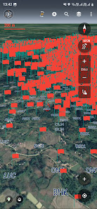
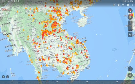
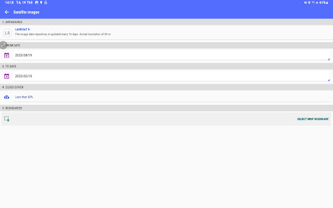
- The feature allows users to directly find and use Landsat 8 satellite image data (16-day update cycle) and Sentinel 2 (5-day update cycle) from the image database.
- Location view feature with 3D perspective with global elevation digital model.
If you need assistance please contact us at the following information:
Facebook: https://www.facebook.com/vToolsForMapInfo
Email: vtools.cskh@gmail.com
Phone (Zalo, WhatsApp, Viber, Telegram): (+84) 96 990 4596
Website: https://apps.vtools.xyz
Youtube: https://www.youtube.com/c/vTools/playlists
All Rights Reserved. Copyright © vTools Apps
Fully integrated with the same functions as a handheld GPS and also adds many new functions to turn your phone into a powerful tool to support field survey and planning. Field management is the easiest.
The main functions of the application:
- Positioning, current position, practical view angle in the field. Help identify better directions.
- Allows users to directly create objects (Points, Lines, Polygons, Coordinate Waypoints, Tracklog routes).
- Allows rapid measurement of the area and length of objects in the field.
- Users can simultaneously create Tracklog, Point, Line, and Polygon at the same time while moving. Tracklog mode allows running in the background.
- Support to save attribute information and images in the field.
- Users can define attribute fields to collect. And share quickly to the whole group via QR code or export to file.
- Find for waypoint, enter a list of waypoints from data TEXT(*.txt), Excel (*.xls, *.xlsx), CSV (*.csv) Excel and convert point coordinates directly on the device.
- Allow to enter the list of points to check by hand (For example, it is necessary to check the location of the extract of the red book).
- Support directly opening common data such as Excel, GPS/GPX, KML/KMZ, GeoJSON, AutoCAD DXF, MicroStation DGN, ESRI Shapefile SHP, MapInfo TAB, gCadas GTP, GeoTIFF, JPG, PNG
- Support export data to GPX, KML, GeoJSON, Excel, AutoCAD DXF, MapInfo TAB, Shapefile SHP format and share via Email, Drive, Zalo, Facebook etc.
- Fully support the VN 2000 projection system of the local and nationwide of Vietnam.
- Support more than 5000 projection systems of other countries and territories in the world.
- Support for old projection systems like Hanoi 1972 (HN 72).
- Support numerical compass feature
- Support reading offline map data MBTiles and intelligent management of data layers.
- Support with simple MBTiles convert tool on Desktop, help to view properties directly from MBTiles layer.
- Support conversion of TCVN3, VNI encoding for Vietnamese font in viewing attribute information.
- Support field photography, save location, shooting direction on images and Exif information, GeoTag
- Allow users to download Google, MapBox, Bing, ESRI, OSM directly on the computer for offline use.
- Support web map service TMS and WMS.
- The feature allows users to directly find and use Landsat 8 satellite image data (16-day update cycle) and Sentinel 2 (5-day update cycle) from the image database.
- Location view feature with 3D perspective with global elevation digital model.
If you need assistance please contact us at the following information:
Facebook: https://www.facebook.com/vToolsForMapInfo
Email: vtools.cskh@gmail.com
Phone (Zalo, WhatsApp, Viber, Telegram): (+84) 96 990 4596
Website: https://apps.vtools.xyz
Youtube: https://www.youtube.com/c/vTools/playlists
All Rights Reserved. Copyright © vTools Apps
Updated on
Safety starts with understanding how developers collect and share your data. Data privacy and security practices may vary based on your use, region, and age. The developer provided this information and may update it over time.

No data shared with third parties
Learn more about how developers declare sharing

No data collected
Learn more about how developers declare collection

Data is encrypted in transit

Data can’t be deleted
Ratings and reviews
5.0
23 reviews
What's new
Updated version v7.2.9
- Updated libs core and optimization app
- Updated libs core and optimization app
App support
phone
Phone number
+84969904596
