
Simrad: Companion for Boaters
In-app purchases
3.9star
1.06K reviews
100K+
Downloads

Everyone
info


About this app
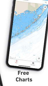
With detailed charting powered by C-MAP®, weather and marine traffic information, route planning and GPS, it is the perfect aid to navigation for boaters, and is a must-have for water-lovers with Simrad on-board.
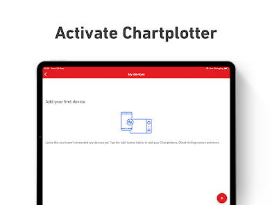
Get started –
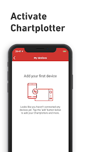
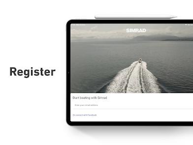
The Simrad App can be used as a standalone or synced with your system. Get started by connecting and registering your chartplotter to your phone via the App...
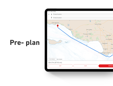
Explore more –
Use the App to plan your routes and mark waypoints in advance or as an aid to navigation while out and about on the water. With detailed charts, Autorouting™ and AIS, it’s a powerful tool to have at your fingertips.
Simply download offline charts, save your favourite routes and waypoints in the app, so you can enjoy your time on the water and make the most of your time fishing or adventuring.
The Simrad App Includes:
- Activation and Registration of your Simrad Chartplotter
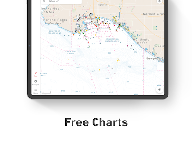
- FREE C-MAP Chart Viewer
- Autorouting™ – find the best route to your favourite places
- Personal Waypoints
- Track Recording
- Thousands of pre-loaded Points of Interest, including relevant information about marinas, harbours, beaches, shops and much more
- Marine Weather Forecast
- Weather Along the Route
- Weather Overlay
- Chart Personalisation
- Import & Export GPX Files – share your Routes, Tracks or Waypoints with friends
- Measure Distance Tool
Upgrade to Premium to unlock additional features, including:
- Full GPS Functionality
- Offline Map Downloads
- REVEAL Shaded Relief
- High-Resolution Bathymetry
- Custom Depth Shading
- AIS & C-MAP Traffic
Try before you buy… Experience the Simrad App Premium for yourself, with a free 14-day trial.
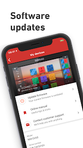
The Simrad App updates on a continuous basis to make sure you get the best experience and to bring you the most up-to-date maps and functionalities.
Compatible with:
GO5 XSE; GO7 XSR; GO9 XSE; GO12 XSE
NSS Evo3; NSS Evo3S; NSX
Privacy policy:
https://appchart.simrad-yachting.com/privacy.html
Terms of service:
https://appchart.simrad-yachting.com/tos.html
Get started –
The Simrad App can be used as a standalone or synced with your system. Get started by connecting and registering your chartplotter to your phone via the App...
Explore more –
Use the App to plan your routes and mark waypoints in advance or as an aid to navigation while out and about on the water. With detailed charts, Autorouting™ and AIS, it’s a powerful tool to have at your fingertips.
Simply download offline charts, save your favourite routes and waypoints in the app, so you can enjoy your time on the water and make the most of your time fishing or adventuring.
The Simrad App Includes:
- Activation and Registration of your Simrad Chartplotter
- FREE C-MAP Chart Viewer
- Autorouting™ – find the best route to your favourite places
- Personal Waypoints
- Track Recording
- Thousands of pre-loaded Points of Interest, including relevant information about marinas, harbours, beaches, shops and much more
- Marine Weather Forecast
- Weather Along the Route
- Weather Overlay
- Chart Personalisation
- Import & Export GPX Files – share your Routes, Tracks or Waypoints with friends
- Measure Distance Tool
Upgrade to Premium to unlock additional features, including:
- Full GPS Functionality
- Offline Map Downloads
- REVEAL Shaded Relief
- High-Resolution Bathymetry
- Custom Depth Shading
- AIS & C-MAP Traffic
Try before you buy… Experience the Simrad App Premium for yourself, with a free 14-day trial.
The Simrad App updates on a continuous basis to make sure you get the best experience and to bring you the most up-to-date maps and functionalities.
Compatible with:
GO5 XSE; GO7 XSR; GO9 XSE; GO12 XSE
NSS Evo3; NSS Evo3S; NSX
Privacy policy:
https://appchart.simrad-yachting.com/privacy.html
Terms of service:
https://appchart.simrad-yachting.com/tos.html
Updated on
Safety starts with understanding how developers collect and share your data. Data privacy and security practices may vary based on your use, region, and age. The developer provided this information and may update it over time.


Ratings and reviews
4.0
981 reviews

Sergio Chaviano
- Flag inappropriate
July 10, 2023
I don't know what has happened, but the app and navigation features of my G09 have fallen off a cliff. Autorouting does not work at all. It only allows two points and routes over land on the intracoastal. The app is so limited in features that it seems like the programmer has little experience and capacity. Syncing is a mess and features like deleting all routes to start all over again do not work. I have tried to get help through the app and there have been no responses. So disappointed.
8 people found this review helpful

HM
- Flag inappropriate
July 25, 2023
what is wrong with those programmers !!!! all we want is a Simple way to: select a location on the map, and do a GOTO that location (duh... of course it is from my actual position), and that's it !! and show the BRG XTE Speed . and alert us 5/10 mins before reaching waypoint. why do they complicate things. Routes can be just a list of those waypoints, to quickly select next destination. gosh!
10 people found this review helpful

Jeffery Pyle
- Flag inappropriate
- Show review history
March 13, 2023
I can't preview the app without creating an account or logging into Facebook. I boat on an inland lake where the biggest navigation issue is finding which cove to turn into for a particular lakefront business. I'd like to see if this app can handle navigation like that. Other apps require me to plot a point-by-point course. That's probably fine for open-water navigation but complete impractical on a lake that twists and turns and has many coves.
2 people found this review helpful
Navico Norway AS
March 17, 2023
Thank you for wanting to try out our app. Please follow the link where you can find all data that our cartography covers. This would be the same as the app.
https://www.c-map.com/chartexplorer/
What's new
We've focused on fixing bugs to make sure you're having the smoothest experience! Enjoy the app!


