

Survey Calculator Pro

4.4star
872 reviews
100K+
Downloads

Everyone
info


About this app
The "Land Survey Calculator" is an essential calculation program designed for fieldwork. It covers a wide range of transportation engineering survey calculations that are required for everyday survey work. It is important to note that the accuracy of the results obtained from this calculator depends on careful input without any mistakes. Therefore, we highly recommend double-checking the results with other platforms before proceeding with any project.
The "Survey Calculator Pro" (offers several programs including:
1. Bearing Distance Calculator: This program calculates Rectangular Coordinate <=> Polar Coordinate vice versa. It is the surveyor's everyday essential COGO program.
2. Intersection Point Calculator: The Intersection program calculates the intersection coordinates of two given lines. You can input 4 points' coordinates or 2 points & 2 bearings.
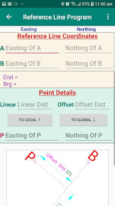
3. Reference Line Program or Line and Offset Program: This program calculates Local Linear & Offset Distance <=> Global Easting & Northing vice versa. It is the most needed every day essential COGO program for land surveyors.
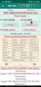
4. The most effective approach for handling full road, bridge or railway alignments is to create the complete alignment in Civil 3D, export it as a LandXML file, and then import it into the field calculation setup. This program accepts Civil 3D LandXML alignment data and calculates the Local Chainage & Offset <=> Global Easting & Northing vice versa. Also, this program can give multiple results for a given start chainage and an interval within the curve.
5. 3 Point Circle (or) Curve - Program calculates the center point coordinate and radius of the curve passing through the 3 given points.
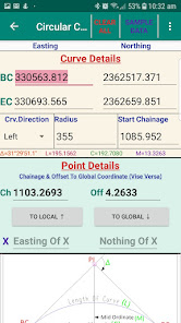
6. Circular Curve Setting Out Calculator: The circular curve setting out calculator program calculates the coordinate of the point within the circular curve. This program calculates the Local Chainage & Offset <=> Global Easting & Northing vice versa. Also, this program can give multiple results for a given start chainage and an interval within the curve.
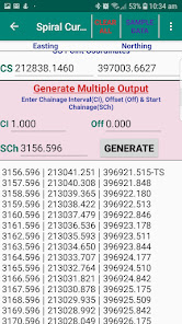
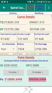
7. Spiral Curve Setting Out Calculator: The spiral curve setting out calculator program calculates the coordinate of the point within the group of transition or spiral and circular curve. Local Chainage & Offset <=> Global Easting & Northing vice versa. Also, this program can give multiple results for a given start chainage and an interval within the curve.
8. Spiral Segment: Newly added.
The Spiral Segment program is used to calculate the coordinate of a point with start and end with custom radius of spiral curve. This program calculates the local chainage and offset, and global easting and northing vice versa, for a given start chainage and an interval within the curve.
9. Vertical Curve Setting Out Calculator: This vertical curve program calculates the parabolic tangent offset at the given chainage. Also, this program can give multiple results for a given start chainage and an interval within the curve.
10. 2D Transformation Calculator: This program transforms coordinates between different coordinate origin and orientation, Source to Destination vice versa. It is the most needed every day essential COGO program for land surveyors.
11. Area By Coordinate Calculator: This program calculates the area of any polygon with the given XY coordinates.
12. Link Traverse Calculation by Bowditch Rule: The Traverse Calculation by Bowditch Rule program will calculate & give adjustment for angle traverse by Bowditch or Compass rule (25 unknown STN max). When you do the angle traverse at site on time you can input the angle traverse details and quickly can get the traverse line accuracy details and final adjusted coordinates. Bowditch Rule or Compass rule is the most common method of traverse adjustment.
13. Coordinate by Triangulation: This program helps to calculate the third unknown point coordinate with 2 known reference points and the distance from the unknown point.
14. Lat Long - UTM Coordinate Converter
The "Survey Calculator Pro" (offers several programs including:
1. Bearing Distance Calculator: This program calculates Rectangular Coordinate <=> Polar Coordinate vice versa. It is the surveyor's everyday essential COGO program.
2. Intersection Point Calculator: The Intersection program calculates the intersection coordinates of two given lines. You can input 4 points' coordinates or 2 points & 2 bearings.
3. Reference Line Program or Line and Offset Program: This program calculates Local Linear & Offset Distance <=> Global Easting & Northing vice versa. It is the most needed every day essential COGO program for land surveyors.
4. The most effective approach for handling full road, bridge or railway alignments is to create the complete alignment in Civil 3D, export it as a LandXML file, and then import it into the field calculation setup. This program accepts Civil 3D LandXML alignment data and calculates the Local Chainage & Offset <=> Global Easting & Northing vice versa. Also, this program can give multiple results for a given start chainage and an interval within the curve.
5. 3 Point Circle (or) Curve - Program calculates the center point coordinate and radius of the curve passing through the 3 given points.
6. Circular Curve Setting Out Calculator: The circular curve setting out calculator program calculates the coordinate of the point within the circular curve. This program calculates the Local Chainage & Offset <=> Global Easting & Northing vice versa. Also, this program can give multiple results for a given start chainage and an interval within the curve.
7. Spiral Curve Setting Out Calculator: The spiral curve setting out calculator program calculates the coordinate of the point within the group of transition or spiral and circular curve. Local Chainage & Offset <=> Global Easting & Northing vice versa. Also, this program can give multiple results for a given start chainage and an interval within the curve.
8. Spiral Segment: Newly added.
The Spiral Segment program is used to calculate the coordinate of a point with start and end with custom radius of spiral curve. This program calculates the local chainage and offset, and global easting and northing vice versa, for a given start chainage and an interval within the curve.
9. Vertical Curve Setting Out Calculator: This vertical curve program calculates the parabolic tangent offset at the given chainage. Also, this program can give multiple results for a given start chainage and an interval within the curve.
10. 2D Transformation Calculator: This program transforms coordinates between different coordinate origin and orientation, Source to Destination vice versa. It is the most needed every day essential COGO program for land surveyors.
11. Area By Coordinate Calculator: This program calculates the area of any polygon with the given XY coordinates.
12. Link Traverse Calculation by Bowditch Rule: The Traverse Calculation by Bowditch Rule program will calculate & give adjustment for angle traverse by Bowditch or Compass rule (25 unknown STN max). When you do the angle traverse at site on time you can input the angle traverse details and quickly can get the traverse line accuracy details and final adjusted coordinates. Bowditch Rule or Compass rule is the most common method of traverse adjustment.
13. Coordinate by Triangulation: This program helps to calculate the third unknown point coordinate with 2 known reference points and the distance from the unknown point.
14. Lat Long - UTM Coordinate Converter
Updated on
Safety starts with understanding how developers collect and share your data. Data privacy and security practices may vary based on your use, region, and age. The developer provided this information and may update it over time.

No data shared with third parties
Learn more about how developers declare sharing

No data collected
Learn more about how developers declare collection
Ratings and reviews
4.3
849 reviews

Waqas Ahmad
- Flag inappropriate
January 27, 2024
Very good application I'm using this from very long time and giving best results and saving my times . But i suggest to add camera option to get coordinate by using pictures or using by camera . Also add import option to get all coordinates at one click to use it later your work. Good keep it up ...❤️
9 people found this review helpful

prithwish das
- Flag inappropriate
- Show review history
August 7, 2022
Dear Developer, Thanks for making this .In daily work it help us all.can you make app only for traverse calculations where user have choice to confirm any two point as known point.It may be the middle of the traverse point or any point .It will help us to monitoring the Control point for long period.As you know after fixing control point for any project some are damaged while working.That time it will helps to re-established control point with old references. Note:starnet software
12 people found this review helpful

Alaka Taofeeq Afolabi
- Flag inappropriate
March 31, 2024
CSV To AutoCAD on my laptop prompt me to install this app on my phone for registration on the software, I can get the registration code from the app and the app only activate for 30 days, kindly help to resolve this
What's new
New program "XML Alignment Reference Line" calculation tool added.
Bug fixes.
Bug fixes.