MapPad GPS Land Surveys
Contains adsIn-app purchases
3.2star
2.46K reviews
500K+
Downloads

Everyone
info


About this app
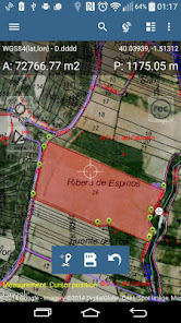
Use MapPad to calculate areas, perimeters and distances and save, export or share your measurements.
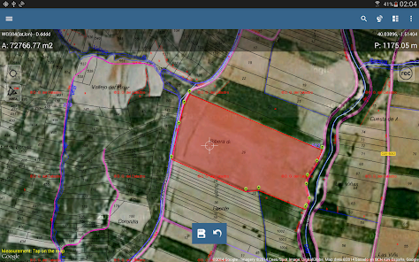
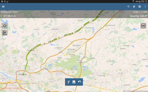
MapPad is providing multi-purpose mapping solution allowing location capture and determines distance and area for the shapes drawn on the map or captured using real-time GPS tracking.
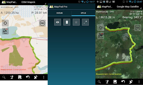
Calculate area of the field or a walk distance instantly using Google or Bing Map Satellite view. Save petrol and time and capture features with few clicks on the map.
With MapPad you can capture, manage and share your data easily.
MapPad is a very useful tool for anyone involved in forestry, agriculture, engineering and real estate management.
Please visit our website to find out how to prepare offline map and get more information about this product.
Selected features:
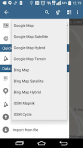
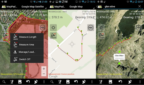
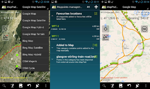
- Base maps: Google Maps, Open Street Map, Bing Maps
- Google Maps Overlays (Custom WMS or ArcGIS Server Tiled service), some layers like US Topographic map have been predefined.
- Very accurate measurement of areas and distances.
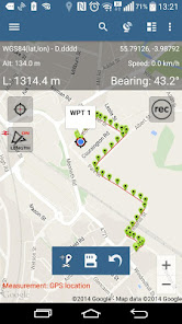
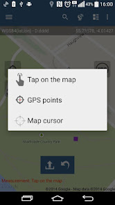
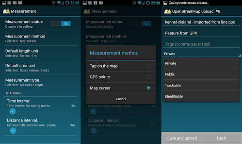
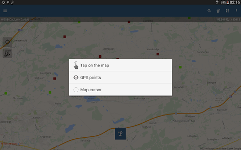
- 3 methods of measurement are supported (Tap on the map, GPS location, Map cursor location).
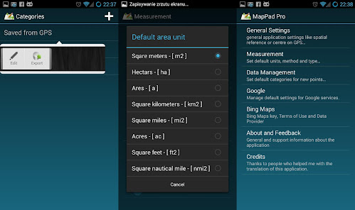
- Support for number of metric and imperial units.
- Support for several global and local coordinate systems, if you require support for any other spatial reference please get in touch.
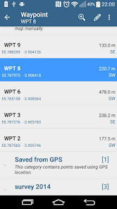
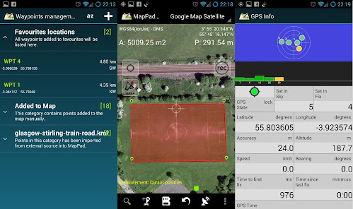
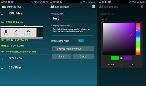
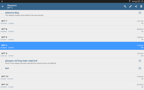
- Possibility to capture waypoints and group them in categories.
- Possibility to add or edit title and description for each recorded measurement and waypoint.
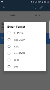
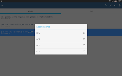
- Export single or multiple measurements or waypoints to SHP File, Geojson, ArcGIS Json, KML, GPX, CSV and DXF to SD Card or cloud services las well as direct export to Open Street Map.
- Share single waypoint location directly by SMS, E-mail or other ways.
- Elevation profile available for measurements done by GPS.
- Import of KML and GPX files to the application.
- GPS status and satellites status.
- Address, location search.
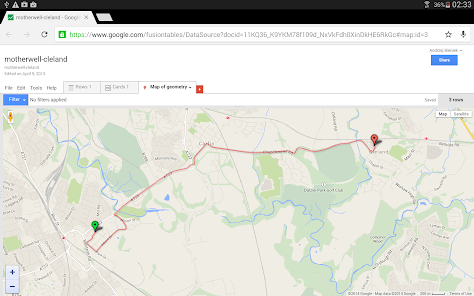
- Quick open exported KML files in Google Earth
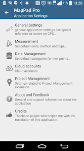
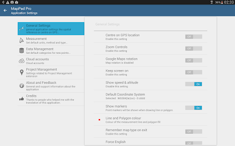
- Ability to set default measurement units, waypoints' categories colours, track recording time and distance interval, transparency of Google Maps overlays and much more...
Our users are successfully using MapPad in number of projects and applications.
MapPad is providing multi-purpose mapping solution allowing location capture and determines distance and area for the shapes drawn on the map or captured using real-time GPS tracking.
Calculate area of the field or a walk distance instantly using Google or Bing Map Satellite view. Save petrol and time and capture features with few clicks on the map.
With MapPad you can capture, manage and share your data easily.
MapPad is a very useful tool for anyone involved in forestry, agriculture, engineering and real estate management.
Please visit our website to find out how to prepare offline map and get more information about this product.
Selected features:
- Base maps: Google Maps, Open Street Map, Bing Maps
- Google Maps Overlays (Custom WMS or ArcGIS Server Tiled service), some layers like US Topographic map have been predefined.
- Very accurate measurement of areas and distances.
- 3 methods of measurement are supported (Tap on the map, GPS location, Map cursor location).
- Support for number of metric and imperial units.
- Support for several global and local coordinate systems, if you require support for any other spatial reference please get in touch.
- Possibility to capture waypoints and group them in categories.
- Possibility to add or edit title and description for each recorded measurement and waypoint.
- Export single or multiple measurements or waypoints to SHP File, Geojson, ArcGIS Json, KML, GPX, CSV and DXF to SD Card or cloud services las well as direct export to Open Street Map.
- Share single waypoint location directly by SMS, E-mail or other ways.
- Elevation profile available for measurements done by GPS.
- Import of KML and GPX files to the application.
- GPS status and satellites status.
- Address, location search.
- Quick open exported KML files in Google Earth
- Ability to set default measurement units, waypoints' categories colours, track recording time and distance interval, transparency of Google Maps overlays and much more...
Our users are successfully using MapPad in number of projects and applications.
Updated on
Safety starts with understanding how developers collect and share your data. Data privacy and security practices may vary based on your use, region, and age. The developer provided this information and may update it over time.

No data shared with third parties
Learn more about how developers declare sharing

No data collected
Learn more about how developers declare collection
Ratings and reviews
3.3
2.24K reviews

liana hesler
- Flag inappropriate
August 12, 2021
Love this app! This makes my cemetery map project so much easier. Typically, I won't pay for the pro versions of any app but this one I did. It's convenient to be able to mark multiple points quickly and edit later, or mark and edit at I go. I especially love that I can add photos. The only snag I have is that the app downsizes when I click the back option from the data management screen. Not big enough of an issue to take any stars away.
88 people found this review helpful

Sun Grown
- Flag inappropriate
October 12, 2020
Doesn't work on Android 11 Very frustrating. I can add waypoints but can't measure between them. When tapping on a waypoint to select it, it automatically moves and changes its coordinates. When in the submenus and hitting the return arrow the program exits and freezes. There are a lot more issues than this, it's completely unusable.
54 people found this review helpful

A Google user
- Flag inappropriate
April 18, 2020
Got it last week to survey some land and next day paid for the Pro license. It's simple, fast, light and gets the job done. I'm having a few issues with some "ghost" projects that after deleted still show in the list and a tracking that can't be edited and crashes the app. But, still , it functions really really well. I gave 5 stars. The f(x) to create a waypoint ("project waypoint") using distance + azimuth COULD be made a lot BETTER of it accepted decimals, instead of only integers.
130 people found this review helpful
What's new
FIX: The app was not working with Android 9 - now fixed.


