

OruxMaps GP
In-app purchases

4.0star
6.54K reviewsinfo
100K+
Downloads

PEGI 3
info


About this app
You can use OruxMaps for your outdoor activities.
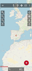
It is an Online and offline map viewer. With this app you can use different map formats, like GeoPDF from USGS store, GeoTIFF maps, .ozf2, .img garmin (vectorial, no full support is provided), .mbtiles, and others.
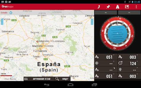
Online maps: You can use the application as a WMS and WMTS online map viewer. Download online maps for offline use. NOT ALL ONLINE MAP SOURCES ARE NOW DOWNLOADABLE. SELECT ANOTHER SOURCE IF YOU CAN NOT FIND THE OPTION TO DOWNLOAD A MAP.
NEW! Added featured Mapbox and Google online maps (subscription required).
You can register into OruxMaps servers, but it is not mandatory, the app will work without this step. If you register an account, the app will ask for various personal information, including an email account, date of birth, sex, weight and height. This data will be stored on an OruxMaps server, and will not be shared with any other user, person or company; they are only at your disposal. If you delete your account, that data is deleted from the server.
If you want to use the 'multitracking' option, the app will ask you to choose in your contacts the emails of the users with whom you want to share your position. The email of these people will be stored on the server, so you can share your position with them. These emails will only be used for this purpose. If you delete your account, this information will also be removed from the server.
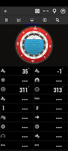
Support to multiple external devices, like external GPS, heart rate monitors, (including bluettoh smart 4.0 devices), bike cadence and speed, bike power, ANT+ (speed, cadence, heart rate, distance, cycle power, temperature).
It also can be used to control the tire pressure/temperaure.
And you can connect to AIS information systems for nautical sports, using Wifi, BT or USB.
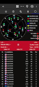
You can see Routes and Tracks in different formats, like KML KMZ, TCX, FIT, CSV, SHP and GPX.
Share your position with your friends, display the position of your friends in your device.
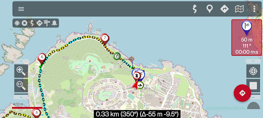
Follow routes, with different alarms to alert you if you are near a waypoint, or you are far from the route.
Geofence/exclusion zone alarms with KML/KMZ overlays.
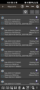
Create/save wayponits, attaching photo/audio/video extensions.
Custom Waypoint types, with your own icons. Attach forms to the Waypoints.
Basic support to Geocaching.
Correct the altitude of your tracks/routes using DEM files (offline) or online services.
Track editor tool. Modify track points (add, remove, move) if they are wrong.
Search/download tracks from different sources, like gpsies.com
Search or create tracks using online services from Graphopper or offline using Brouter app.
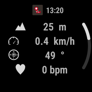
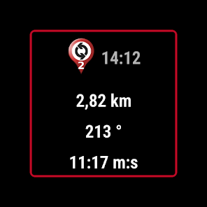
A simple app for Wear OS is included, allowing you to display basic data (a dashboard) and a simplified map (not synchronized with the map on the main device).
More information on the website.
It is an Online and offline map viewer. With this app you can use different map formats, like GeoPDF from USGS store, GeoTIFF maps, .ozf2, .img garmin (vectorial, no full support is provided), .mbtiles, and others.
Online maps: You can use the application as a WMS and WMTS online map viewer. Download online maps for offline use. NOT ALL ONLINE MAP SOURCES ARE NOW DOWNLOADABLE. SELECT ANOTHER SOURCE IF YOU CAN NOT FIND THE OPTION TO DOWNLOAD A MAP.
NEW! Added featured Mapbox and Google online maps (subscription required).
You can register into OruxMaps servers, but it is not mandatory, the app will work without this step. If you register an account, the app will ask for various personal information, including an email account, date of birth, sex, weight and height. This data will be stored on an OruxMaps server, and will not be shared with any other user, person or company; they are only at your disposal. If you delete your account, that data is deleted from the server.
If you want to use the 'multitracking' option, the app will ask you to choose in your contacts the emails of the users with whom you want to share your position. The email of these people will be stored on the server, so you can share your position with them. These emails will only be used for this purpose. If you delete your account, this information will also be removed from the server.
Support to multiple external devices, like external GPS, heart rate monitors, (including bluettoh smart 4.0 devices), bike cadence and speed, bike power, ANT+ (speed, cadence, heart rate, distance, cycle power, temperature).
It also can be used to control the tire pressure/temperaure.
And you can connect to AIS information systems for nautical sports, using Wifi, BT or USB.
You can see Routes and Tracks in different formats, like KML KMZ, TCX, FIT, CSV, SHP and GPX.
Share your position with your friends, display the position of your friends in your device.
Follow routes, with different alarms to alert you if you are near a waypoint, or you are far from the route.
Geofence/exclusion zone alarms with KML/KMZ overlays.
Create/save wayponits, attaching photo/audio/video extensions.
Custom Waypoint types, with your own icons. Attach forms to the Waypoints.
Basic support to Geocaching.
Correct the altitude of your tracks/routes using DEM files (offline) or online services.
Track editor tool. Modify track points (add, remove, move) if they are wrong.
Search/download tracks from different sources, like gpsies.com
Search or create tracks using online services from Graphopper or offline using Brouter app.
A simple app for Wear OS is included, allowing you to display basic data (a dashboard) and a simplified map (not synchronized with the map on the main device).
More information on the website.
Updated on
Safety starts with understanding how developers collect and share your data. Data privacy and security practices may vary based on your use, region, and age. The developer provided this information and may update it over time.

No data shared with third parties
Learn more about how developers declare sharing

This app may collect these data types
Location, Personal info and 4 others

Data is encrypted in transit

You can request that data be deleted
Ratings and reviews
3.9
6.1K reviews

Jai Turner
- Flag inappropriate
April 7, 2024
This app was recommended by openseamaps / openstreetmaps. I bought it, but wouldn't again. A very clunky user interface. Downloading offline maps is a nightmare and so far cannot find a useful way to download openseamaps, the whole reason I bought it. Virtually no documentation to work from either. If you want ocean mapping, bite the bullet and pay for Navionics; it works.
1 person found this review helpful

Antonio Peres
- Flag inappropriate
- Show review history
February 23, 2024
App has some great capabilities most of which got broken starting version 9. OSM track integration - broken, raster image caching - broken since day 1, poor documentation, super non-intuitive UI (took me years to get used to it and I'm an experienced IT and GPS user), loading large number of tracks and waypoints - forget it in GPX or SHP, only KMZ works fine, can't visualize Garmin NT format maps, can't load both vector and raster map with different transparency, you can't select an area and force-download a raster map for it on all zoom levels, it contains tons of useless non-related features like conmectivity to smartwatch sensors amd whatnot, and what is worse of all - developer stopped replying to bug reports let alone fixing his own code regressions...On the bright side it supports non-NT Garmin maps, WMS, TMS, some fine-tuning on track creation and that's about it.
8 people found this review helpful

Liberty Toad
- Flag inappropriate
- Show review history
April 10, 2024
The battery usage is very low. The UI is powerful, but you do need to mess around with it a bit to set it up and get used to it. Setting up the buttons you want to use makes this easier. DEM data works well, but getting the right area takes some trial and error. Track recording does not always record, sometimes it works, sometimes it doesn't. I tried to find a pattern for it but did not see one. It used to always work.
67 people found this review helpful
What's new
—>Added RTK ntrip client.
—>Improved forms.
—>Mapsforge poi search improved.
—>SICAMI integration improved.
—>New GIS calculator.
—>Bug corrections.
—>Improved forms.
—>Mapsforge poi search improved.
—>SICAMI integration improved.
—>New GIS calculator.
—>Bug corrections.


