
Mapit Spatial - GIS Collector
4.3star
208 reviews
10K+
Downloads

Rated for 3+
info


About this app
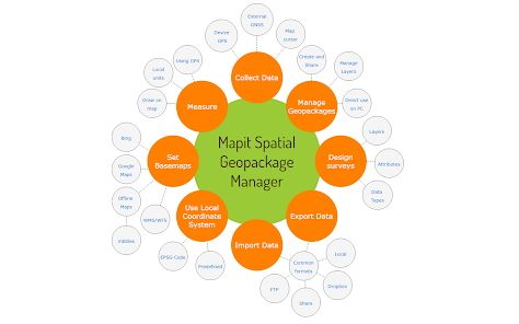
This application is our flag product and more sophisticated version of the older apps called MapPad and Mapit GIS with some new ideas implemented and completely redesigned data management approach and is providing multi-purpose mapping solution allowing location capture and determines distance and area for the shapes drawn on the map or captured using real-time GPS tracking.
Core functionality:
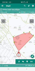
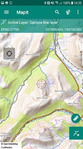
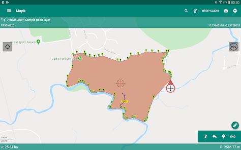
- collection of spatial data in form of POINT, LINE or POLYGON datasets,
- calculation of areas, perimeters and distances.
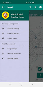
- management of the data in form of geopackage projects
- survey design
- data sharing
Application requires access to the file system on the device and from Android 11+ "manage external storage" permission must be accepted to provide the core functionality described above.
The app is designed to be simple and light and driven by new OGC file format for storing spatial data.
Detailed user guide in form of pdf document is available on our website - https://spatial.mapitgis.com/user-guide
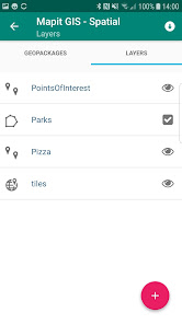
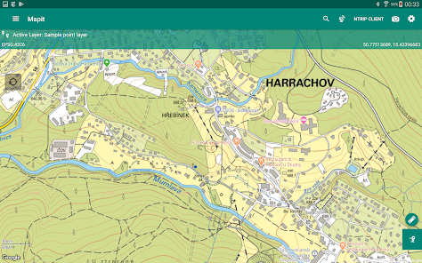
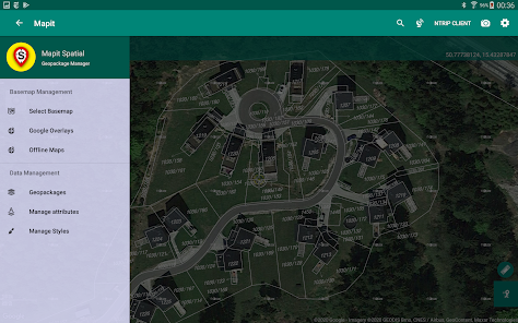
Directly from the app you can access existing multiple Geopackages data sources and their content presented as tiled or feature layers.
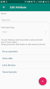
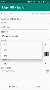
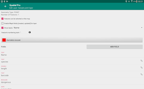
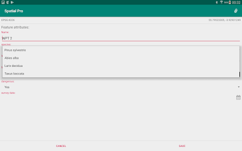
You can also create new Geopackage databases and feature layers and link their fields with the attribute set fields, so the data can be then collected using forms containing drop-down lists, multi-select list, barcode scanner etc. Please see our website for more details.
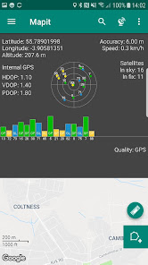
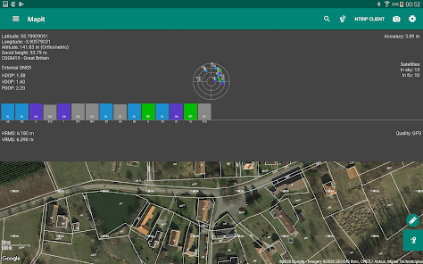
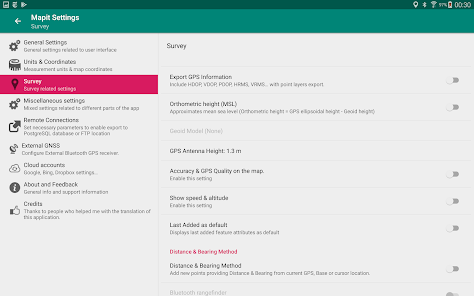
The application is supporting multiple coordinates projections and you can specify your default coordinate system by providing the EPSG code in the settings - PRJ4 library is used to convert coordinates.
The application is capable to link with high precision GNSS systems - so you can get down to centimetre accuracy if required and take advantage of the RTK solutions provided by the leading GNSS manufacturers.
With Mapit Spatial you can capture, manage and share your data easily. Supported export and import formats: SHP File, GeoJSON, ArcJSON, KML, GPX, CSV and AutoCAD DXF.
Custom WMS, WMTS, WFS, XYZ or ArcGIS Server Tiled services can be added to the software in form of overlays.
Three methods of measurement are supported in form of GPS location, Map cursor location and Distance & Bearing method.
Mapit Spatial can be used in number of applications including:
- environmental surveys,
- woodland surveys,
- forestry planning and woodland management surveys,
- agriculture and soils' types surveys,
- road constructions,
- land surveying,
- solar panels applications,
- roofing and fencing,
- tree surveys,
- GPS and GNSS surveying,
- site surveying and soil samples gathering
- snow removal
The GIS Software and spatial data gathering and processing is getting more and more important these days all over the world and the ability having quick, fast and reliable workflow is becoming very important. Mapit Pro has become a day-to-day tool for thousands of people across the world and we are hoping that Mapit Spatial is going to improve and make your workflow more efficient and cost-effective.
We would like to address our application to everyone who is working with
geographic data and is responsible for location related tasks. There is
number of science and business-related areas relying or depending on the
accurate information coming from Geographic Information Systems and we hope Mapit Spatial is going to become your day-to-day tool when you are
making things right out there in the field.
The app is dedicated to people working in agriculture,
forestry, housing development or land survey industry, but also to customers
responsible for design work in power industry, water supply and sewage
systems. We have successful customers also from gas and oil industry, telecommunication and road engineering.
Mapit Spatial can be also adopted for any kind of spatial asset management tasks, fishery and hunting, habitat and soil mapping or to whatever needs you can think off, but of which the authors of the application have never thought.
Core functionality:
- collection of spatial data in form of POINT, LINE or POLYGON datasets,
- calculation of areas, perimeters and distances.
- management of the data in form of geopackage projects
- survey design
- data sharing
Application requires access to the file system on the device and from Android 11+ "manage external storage" permission must be accepted to provide the core functionality described above.
The app is designed to be simple and light and driven by new OGC file format for storing spatial data.
Detailed user guide in form of pdf document is available on our website - https://spatial.mapitgis.com/user-guide
Directly from the app you can access existing multiple Geopackages data sources and their content presented as tiled or feature layers.
You can also create new Geopackage databases and feature layers and link their fields with the attribute set fields, so the data can be then collected using forms containing drop-down lists, multi-select list, barcode scanner etc. Please see our website for more details.
The application is supporting multiple coordinates projections and you can specify your default coordinate system by providing the EPSG code in the settings - PRJ4 library is used to convert coordinates.
The application is capable to link with high precision GNSS systems - so you can get down to centimetre accuracy if required and take advantage of the RTK solutions provided by the leading GNSS manufacturers.
With Mapit Spatial you can capture, manage and share your data easily. Supported export and import formats: SHP File, GeoJSON, ArcJSON, KML, GPX, CSV and AutoCAD DXF.
Custom WMS, WMTS, WFS, XYZ or ArcGIS Server Tiled services can be added to the software in form of overlays.
Three methods of measurement are supported in form of GPS location, Map cursor location and Distance & Bearing method.
Mapit Spatial can be used in number of applications including:
- environmental surveys,
- woodland surveys,
- forestry planning and woodland management surveys,
- agriculture and soils' types surveys,
- road constructions,
- land surveying,
- solar panels applications,
- roofing and fencing,
- tree surveys,
- GPS and GNSS surveying,
- site surveying and soil samples gathering
- snow removal
The GIS Software and spatial data gathering and processing is getting more and more important these days all over the world and the ability having quick, fast and reliable workflow is becoming very important. Mapit Pro has become a day-to-day tool for thousands of people across the world and we are hoping that Mapit Spatial is going to improve and make your workflow more efficient and cost-effective.
We would like to address our application to everyone who is working with
geographic data and is responsible for location related tasks. There is
number of science and business-related areas relying or depending on the
accurate information coming from Geographic Information Systems and we hope Mapit Spatial is going to become your day-to-day tool when you are
making things right out there in the field.
The app is dedicated to people working in agriculture,
forestry, housing development or land survey industry, but also to customers
responsible for design work in power industry, water supply and sewage
systems. We have successful customers also from gas and oil industry, telecommunication and road engineering.
Mapit Spatial can be also adopted for any kind of spatial asset management tasks, fishery and hunting, habitat and soil mapping or to whatever needs you can think off, but of which the authors of the application have never thought.
Updated on
Safety starts with understanding how developers collect and share your data. Data privacy and security practices may vary based on your use, region, and age. The developer provided this information and may update it over time.

No data shared with third parties
Learn more about how developers declare sharing

No data collected
Learn more about how developers declare collection
Ratings and reviews
4.3
187 reviews

rentbeachhouse byowner
- Flag inappropriate
- Show review history
March 19, 2024
Im a mapit fan but I've just upgraded to Spatial, and it works well, but the gnss accuracy gets stuck at .75m, even on my phone gps, which is impossible. My rtk receiver also shows the same but on original mapit, It shows .01m. I'm sure its a glitch as the app with correction is very accurate, but I really need the accuracy to display correctly. Please check on this, otherwise the app is great. Follow up... turned on Arrow mode in app, fixed it.

Daniel McCurdy
- Flag inappropriate
May 11, 2021
This is a great app, but the paid subscription features DON'T WORK WHEN YOU'RE OFFLINE! That's a huge problem making it unusable. So, you can't add new layers if you're out of cell contact, you can't add external GPS, and numerous other features that you pay for. Absolutely crazy. The app assumed you aren't paying unless it can constantly ping to check that you are. My paid subscription is for a year. Why doesn't it just check once a year? Developers haven't replied to emails about the issue.
18 people found this review helpful

Margot DC
- Flag inappropriate
- Show review history
April 5, 2021
The app seems logical and easy to use but so far I'm not able to actively track a route AND add points to either of the point layers in the same geopackage. What am I missing? Is it necessary to stop tracking to collect point data? Or, when recording a track, is there a setting that allows the add point feature to add the points to a specific layer? Added note: it looks like assigning a projection other than EPSG 4326 fails.
5 people found this review helpful
What's new
ADD: Added information about polygon features area and line features length in feature's list for a layer.
CHANGE: Improved labels for created/updated fields when those are enabled on the layer.
FIX: Fixed issue with the name name of the features in features' list - now selected label field or name is displayed.
FIX: Fixed issue with a date field on some devices.
CHANGE: Improved labels for created/updated fields when those are enabled on the layer.
FIX: Fixed issue with the name name of the features in features' list - now selected label field or name is displayed.
FIX: Fixed issue with a date field on some devices.


