
Shelter Map (Vindskyddskartan)
In-app purchases
4.2star
220 reviewsinfo
10K+
Downloads

PEGI 3
info


About this app
Do you want to enjoy the wilderness and spend the night outdoors? Or perhaps you're just looking for a nice place to have a coffe break during a hike? There are plenty of hiking shelters all around us, but finding them is usually not easy.
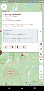
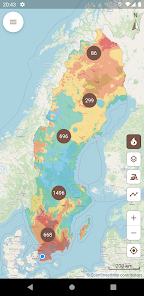
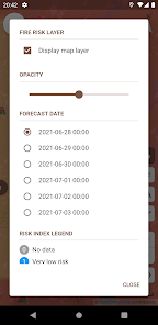
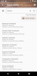
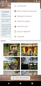
Shelter Map ("Vindskyddskartan" in swedish, the original language of the app) gives you an easy to use overview of thousands of shelters on a map so you can easily find one near your location. The app also gives you easy access to current and forecasted fire risk and fire ban status, so you know when, where and how you can safely enjoy a campfire and cook food in nature.
The app is subscription based, but you can try it for free for 3 days before paying anything. If you prefer to own your apps, you can make a one-time purchase and have unlimited lifetime access to the app. All purchases are made from within the app. Subscriptions renew automatically unless cancelled at least 24 hours before the next renewal. Active subscriptions are managed from the Google Play app, and of course you may cancel your subscription at any time.
Updated on
Safety starts with understanding how developers collect and share your data. Data privacy and security practices may vary based on your use, region, and age. The developer provided this information and may update it over time.


Ratings and reviews
4.2
213 reviews

Alexander Swen
- Flag inappropriate
August 1, 2022
This app shows all beautiful shelters in Sweden in a great way. It's very convenient in usage. Especially cool was the response of the developer(s) after I asked for a feature (the ability to load GPX format track files onto the map so i can easily plan my daily tracks when walking a long route like the Skåneleden): it was added within weeks, i tested it and works like a charm. Absolutely worth the money for the app.

Emil Ciotta
- Flag inappropriate
- Show review history
March 9, 2024
I have used Vindskyddskartan.se for years and have now decided to go for the app with subscribtion. Very useful for planning hiking trips 👍

Chris Klimek
- Flag inappropriate
May 29, 2022
Great app, very helpful. Demo version somehow expired within a few days but cost is very low. Many thanks , you made my holidays so much easier 🥳
What's new
Improved display of GPX tracks, including better performance for large files with long tracks, and viewing of routes and waypoints.


