Rivercast - River Levels App
In-app purchases
4.6star
400 reviews
10K+
Downloads

Everyone
info

About this app
Are you concerned about flooding? Or just want to go find the best time to go fishing or boating? Get river levels & forecasts with Rivercast™ when you need them!
Rivercast™ puts the river level data you need at your fingertips with its intuitive and interactive maps and graphs!
Rivercast™ Features Include:
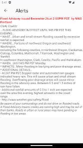
• Official Flood Warnings & other alerts from the National Weather Service
• River stage height in Feet
• River flow rate in CFS (when available)
• Indications that a river is at or approaching flood stage
• User-defined Push Notification Alerts for when river reaches levels of concern to you
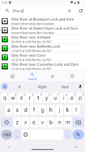
• Current observations and recent history
• NOAA river forecasts (when available)
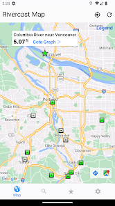
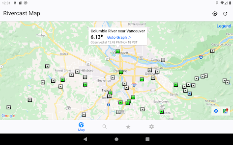
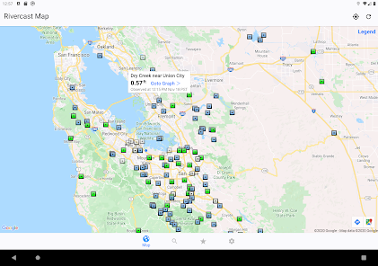
• Map interface that shows where river gauges are located geographically.
• Search interface to find river gauges by waterway name, state, or NOAA 5 digit station ID.
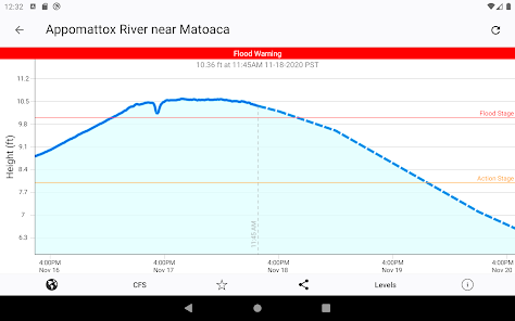
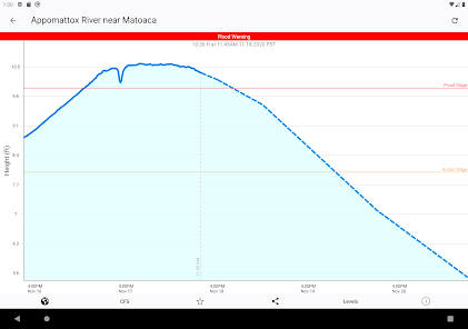
• Interactive graphs that you can zoom in, zoom out, or pan.
• Customize your graphs by adding river levels that are relevant to you.
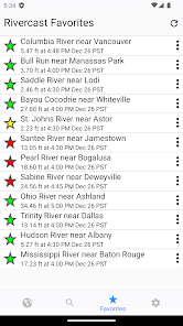
• Favorites list for locations you care about the most.
• Share your graphs via Text, Email, Facebook, Twitter, etc.
• Home Screen Widget to monitor your favorite locations at any time.
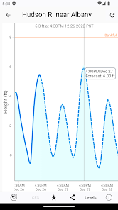
Rivercast's map not only shows you where the stations are, but color codes them when it can to give you an indication whether the location is at normal levels, approaching flood levels, or above flood stage.
You can get the latest observations from the map, search, or favorites. With an additional tap of your finger you can get a detailed interactive hydrograph. You can zoom in, zoom out, or pan with your fingers to find the exact information you need.
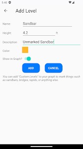
To customize your graphs for what's important to you, you can add your own level lines to mark sandbars, rocks, bridges, safe conditions, etc. for whatever you would like.
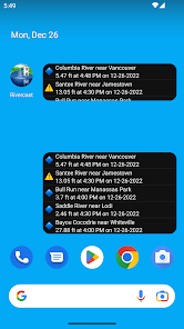
And you can add the streams or rivers that you would like to regularly monitor to your Favorites list for easy "at a glance" viewing.
Rivercast™ uses the latest observation and forecast data available, and requires an Internet connection for use.
Data is viewable in feet or cfs (when available).
All observation and forecast data is in your local time (per your device) for your convenience.
A handy tool for boaters, fishermen, property owners, paddlers, scientists, and the curious.
River gauges reported are USA only.
* * * * * * * * * * * * *
Some Frequent Asked Questions:
Where does Rivercast™ get its data?
• This app uses NOAA and AHPS (Advanced Hydrologic Prediction Service) for its raw data for our custom graphing and mapping solutions. There are a few locations that are available via other government agencies (including USGS) that are not available via this app.
Why does Rivercast™ sometimes show slightly different flow data (CFS) than USGS?
• CFS is a calculated estimate derived from stage height. NOAA and USGS estimates may sometimes slightly vary due to using different data models. Variances are usually within a few percent, but can sometimes be larger. Stage height should always be identical between USGS and NOAA. Designated flood stages are based on stage height in feet in the USA.
Why does Rivercast™ show only observations, but not forecasts, for my river?
• NOAA issues forecasts for many, but not all, rivers it monitors. Sometimes forecasts are only issued seasonally, or during times of flooding or high water.
Can you add location xyz to your app?
• We wish we could! If NOAA is not reporting it, we unfortunately are not able to add it. We include all stations that NOAA provides for public use.
Notice: Raw data used in this app is sourced from www.noaa.gov.
Disclaimer: Rivercast is not affiliated with nor represents NOAA, USGS, or any other government entity.
Rivercast™ puts the river level data you need at your fingertips with its intuitive and interactive maps and graphs!
Rivercast™ Features Include:
• Official Flood Warnings & other alerts from the National Weather Service
• River stage height in Feet
• River flow rate in CFS (when available)
• Indications that a river is at or approaching flood stage
• User-defined Push Notification Alerts for when river reaches levels of concern to you
• Current observations and recent history
• NOAA river forecasts (when available)
• Map interface that shows where river gauges are located geographically.
• Search interface to find river gauges by waterway name, state, or NOAA 5 digit station ID.
• Interactive graphs that you can zoom in, zoom out, or pan.
• Customize your graphs by adding river levels that are relevant to you.
• Favorites list for locations you care about the most.
• Share your graphs via Text, Email, Facebook, Twitter, etc.
• Home Screen Widget to monitor your favorite locations at any time.
Rivercast's map not only shows you where the stations are, but color codes them when it can to give you an indication whether the location is at normal levels, approaching flood levels, or above flood stage.
You can get the latest observations from the map, search, or favorites. With an additional tap of your finger you can get a detailed interactive hydrograph. You can zoom in, zoom out, or pan with your fingers to find the exact information you need.
To customize your graphs for what's important to you, you can add your own level lines to mark sandbars, rocks, bridges, safe conditions, etc. for whatever you would like.
And you can add the streams or rivers that you would like to regularly monitor to your Favorites list for easy "at a glance" viewing.
Rivercast™ uses the latest observation and forecast data available, and requires an Internet connection for use.
Data is viewable in feet or cfs (when available).
All observation and forecast data is in your local time (per your device) for your convenience.
A handy tool for boaters, fishermen, property owners, paddlers, scientists, and the curious.
River gauges reported are USA only.
* * * * * * * * * * * * *
Some Frequent Asked Questions:
Where does Rivercast™ get its data?
• This app uses NOAA and AHPS (Advanced Hydrologic Prediction Service) for its raw data for our custom graphing and mapping solutions. There are a few locations that are available via other government agencies (including USGS) that are not available via this app.
Why does Rivercast™ sometimes show slightly different flow data (CFS) than USGS?
• CFS is a calculated estimate derived from stage height. NOAA and USGS estimates may sometimes slightly vary due to using different data models. Variances are usually within a few percent, but can sometimes be larger. Stage height should always be identical between USGS and NOAA. Designated flood stages are based on stage height in feet in the USA.
Why does Rivercast™ show only observations, but not forecasts, for my river?
• NOAA issues forecasts for many, but not all, rivers it monitors. Sometimes forecasts are only issued seasonally, or during times of flooding or high water.
Can you add location xyz to your app?
• We wish we could! If NOAA is not reporting it, we unfortunately are not able to add it. We include all stations that NOAA provides for public use.
Notice: Raw data used in this app is sourced from www.noaa.gov.
Disclaimer: Rivercast is not affiliated with nor represents NOAA, USGS, or any other government entity.
Updated on
Safety starts with understanding how developers collect and share your data. Data privacy and security practices may vary based on your use, region, and age. The developer provided this information and may update it over time.


Ratings and reviews
4.6
390 reviews

Brett Johnson
- Flag inappropriate
March 27, 2023
Very comprehensive get simple waterway levels. I love the built in Google Maps feature that let's you look at the same station location on Google Maps with the option to get directions to the river gauge station. Really Cool and very useful especially is you are on the road and you need to know what areas to avoid and find a new route!
7 people found this review helpful

Caleb Hess
- Flag inappropriate
- Show review history
March 11, 2024
Edit: it's working now! I don't know what was wrong. It seems like the latest update broke the app. It gets stuck on "retrieving data" I can't see any stations
Juggernaut Technology, Inc.
March 11, 2024
We're glad to hear it is working for you now! Our best guess is there was a Server or Internet connection glitch. Please contact us (Rivercast->Settings->Contact) if it happens again.

Alex Phillips
- Flag inappropriate
February 10, 2024
I have been using the app for the last 4 years and it's my go to for river level and forecast. It is the same info you get from the government website but the app is far quicker and because the color of the markers it's easier to see flood water coming down towards you.
3 people found this review helpful
What's new
+ Performance, User Interface, and Stability improvements.
In case you missed it, you can now Add your own custom River Alerts & Notifications!
If you have any questions, problems, or comments, please email us at help@RivercastApp.com!
In case you missed it, you can now Add your own custom River Alerts & Notifications!
If you have any questions, problems, or comments, please email us at help@RivercastApp.com!


