GNSS Surveyor - Centimeter Lev
In-app purchases
2.2star
143 reviews
10K+
Downloads

Everyone
info

About this app
App features:
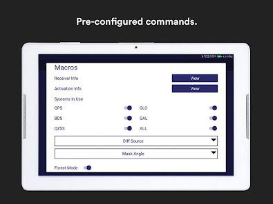
- Easy to use one touch previously configured commands to communicate directly with GNSS Bluetooth device.
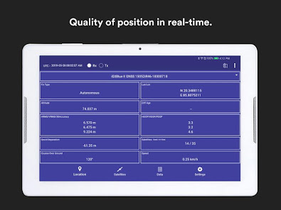
- Display location information and quality of the position data in real-time with sub-meter/ Centimeter accuracy
Receive GPS status data like position, height, accuracy, satellites, velocity, etc.
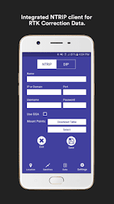
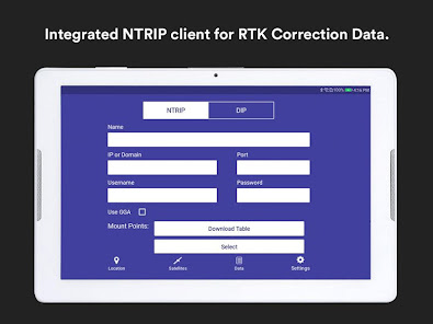
- You can forward RTK correction data to your high accuracy external device. RTCM data is loaded from the internet by the internal NTRIP client.
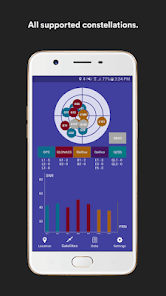
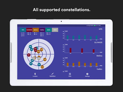
- View all or hide all constellations individually on sky plot and distinct color for different constellations for better identification.
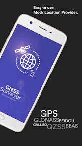
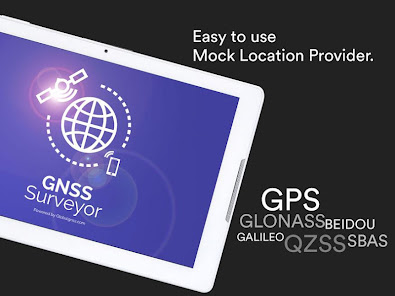
- Constellation information for GPS, GLONASS, GALILEO, BEIDOU, QZSS, SBAS SATELLITES.
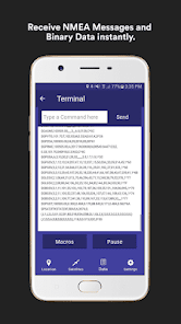
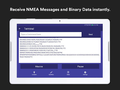
- Send commands to external GPS device and view the output data on Terminal.
- Log all received NMEA messages and BINARY DATA on Terminal window.
- Built-in NTRIP client to access RTK or DGNSS correction from any RTK Network.
- Direct IP feature for RTK corrections data.
- Convert degrees decimal minutes to decimal degrees and vice versa
- Configurable audible and visual alerts.
- Multi language support.
- Multi measurement units support.
How it works?
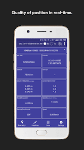
Connect external bluetooth GNSS device with GNSS Surveyor and compare your location with different satellite systems. It provides advanced information such as HRMS, VRMS, 3D RMS values, HDOP, PDOP, VDOP, Differential GPS. Satellites in view.
Easy to allow mock location on your android phone or tablet and use the position of the external receiver in any 3rd party application. Get GPS status data like position, height, accuracy, satellites, and speed in real time. View and analyse the position information provided by the GNSS receivers and metadata related to its location.
Paid Features Available:
- NTRIP (Network Transport of RTCM data over IP)
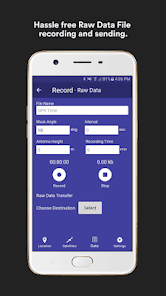
- Record NMEA (Real time position information understand and expect data to be in NMEA format)
- Macros
- Terminal
The following information are displayed:
- Lattitude and longitude
- Altitude
- Speed or pace
- Bearing
- UTC time
- Satellite data (optional)
GNSS precision to the next level, such as:
- Global Coverage
- Centimeter Level Accuracy
- Fast TTFF
- Multi-constellation and multi-band
- Highest security
GNSS surveyor used in various navigation, such as:
- Ground Robotics navigation
- Lane-level navigation
- Heavy machine navigation
- Industrial navigation and tracking
- Commercial UAV
Uses in Different Industry:
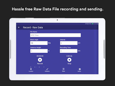
Record and transfer the raw data file allowing post-processing of information for surveying, such as:
- Forestry
- Utilities
- Agriculture
- Environmental
- Oil and GAS
- Marine
.. and other natural resource industry professionals.
Device Compatibility:
Compatible with Android version OS 4.3 and higher
Designed and developed to work with Bluetooth 2.X
Technical Support:
For App crash and technical support, questions, feedback or bug reporting, please raise a ticket at http://globalgnss.com/support/ .
- Easy to use one touch previously configured commands to communicate directly with GNSS Bluetooth device.
- Display location information and quality of the position data in real-time with sub-meter/ Centimeter accuracy
Receive GPS status data like position, height, accuracy, satellites, velocity, etc.
- You can forward RTK correction data to your high accuracy external device. RTCM data is loaded from the internet by the internal NTRIP client.
- View all or hide all constellations individually on sky plot and distinct color for different constellations for better identification.
- Constellation information for GPS, GLONASS, GALILEO, BEIDOU, QZSS, SBAS SATELLITES.
- Send commands to external GPS device and view the output data on Terminal.
- Log all received NMEA messages and BINARY DATA on Terminal window.
- Built-in NTRIP client to access RTK or DGNSS correction from any RTK Network.
- Direct IP feature for RTK corrections data.
- Convert degrees decimal minutes to decimal degrees and vice versa
- Configurable audible and visual alerts.
- Multi language support.
- Multi measurement units support.
How it works?
Connect external bluetooth GNSS device with GNSS Surveyor and compare your location with different satellite systems. It provides advanced information such as HRMS, VRMS, 3D RMS values, HDOP, PDOP, VDOP, Differential GPS. Satellites in view.
Easy to allow mock location on your android phone or tablet and use the position of the external receiver in any 3rd party application. Get GPS status data like position, height, accuracy, satellites, and speed in real time. View and analyse the position information provided by the GNSS receivers and metadata related to its location.
Paid Features Available:
- NTRIP (Network Transport of RTCM data over IP)
- Record NMEA (Real time position information understand and expect data to be in NMEA format)
- Macros
- Terminal
The following information are displayed:
- Lattitude and longitude
- Altitude
- Speed or pace
- Bearing
- UTC time
- Satellite data (optional)
GNSS precision to the next level, such as:
- Global Coverage
- Centimeter Level Accuracy
- Fast TTFF
- Multi-constellation and multi-band
- Highest security
GNSS surveyor used in various navigation, such as:
- Ground Robotics navigation
- Lane-level navigation
- Heavy machine navigation
- Industrial navigation and tracking
- Commercial UAV
Uses in Different Industry:
Record and transfer the raw data file allowing post-processing of information for surveying, such as:
- Forestry
- Utilities
- Agriculture
- Environmental
- Oil and GAS
- Marine
.. and other natural resource industry professionals.
Device Compatibility:
Compatible with Android version OS 4.3 and higher
Designed and developed to work with Bluetooth 2.X
Technical Support:
For App crash and technical support, questions, feedback or bug reporting, please raise a ticket at http://globalgnss.com/support/ .
Updated on
Safety starts with understanding how developers collect and share your data. Data privacy and security practices may vary based on your use, region, and age. The developer provided this information and may update it over time.

No data shared with third parties
Learn more about how developers declare sharing

No data collected
Learn more about how developers declare collection

Data is encrypted in transit

You can request that data be deleted
Ratings and reviews
2.2
136 reviews

Douglas Keene
- Flag inappropriate
- Show review history
April 6, 2021
I would love to see this work to provide 2cm accuracy as advertised. I have not seen it work on Samsung S21 ultra (Android 11). Tech support said they are addressing that. Has anyone gotten this to work on a S21? Does this require a separate bluetooth GNSS receiver to achieve 2cm accuracy? If it can not achieve 2cm accuracy with the newest smartphones, what is the benefit, as there are many apps out there already working. Thanks
12 people found this review helpful

A Google user
- Flag inappropriate
August 15, 2019
Can you provide more description on your paid features such as ntrip configuration and logging. $20 may not be a lot for both but without more details I would not risk it and stick to ntrip client lefebure and a logger as a separate app. Or better please make a trail version for all paid features.
15 people found this review helpful
PoloSoftech
August 15, 2019
send email to our support@globalgnss.com you will get an information for the same

Serge J.Michael Quintal
- Flag inappropriate
March 28, 2023
Must if you want to be as accurate as possible in position but also in communication. Everything is GPS. Many type of geopos. Think. Maybe today glonas is the one. But won't show you how to use it. Classified.


