AGPS Tracker-Om
Contains adsIn-app purchases
5.0star
1.3K reviews
50K+
Downloads

Everyone
info


About this app
A-GPS TrackerOm (previously called A-GPS Tracker++) allows a use of the tracker without internet, using off-line maps. The app provides also the generation of contour lines and some GPX editing functions.
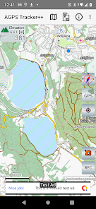
MAPS: The geographic maps used by AGPS-Tracker++ are offline, free maps created and maintained by the OpenStreetMap project (“©Openstreetmap-contributors). These maps are compressed in files with extension “.map” and may be downloaded using A-GPS Tracker++. The first time you run the app your archive is empty and you will be invited to select the map of your country and transfer it to your local archive. You can always download other map files, of other countries, into your local folder.
CONTOUR LINES: are generated automatically by A-GPS Tracker++ when you keep pressed a point of the map. The contour lines are generated starting from Digital Elevation Map (DEM) data files. The DEMs provide an accurate altitude mapping of the terrain (one point every 30m) and have been made available by NASA. They cover all land between 56 degrees south and 60 degrees north. The first time you run the app your DEMs archive is empty. To load a DEM file you just need to keep pressed a point on the map. If you do not have a DEM for this area you will be prompted to load the file from the A-GPS Tracker++ server.
If you keep pressed a point on the map and you have already downloaded the DEM for this area, then you will see the contour lines created by A-GPS Tracker++ around the touched area.
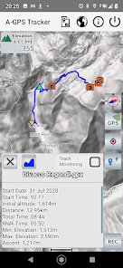
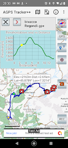
ELEVATION: The elevation is the less precise of the data provided by GPS, it may be subject to unexpected variations. DEMs give an alternative and more stable way to calculate elevation from the knowledge of the geographical position.
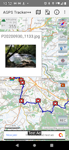
GPX EDITING: A GPX track, already created in your archive, can be loaded and modified in the following ways:
1. Merge two tracks. The first track is simply loaded, a further one may be added.
2. Modify or Delete a Point Of Interest (POI). Select a POI to Delete it or Modify POI name and description.
3. Add a new POI either assigned to a point on the MAP or to a point on the track.
4. Save the resulting track to a new GPX file.
MAPS: The geographic maps used by AGPS-Tracker++ are offline, free maps created and maintained by the OpenStreetMap project (“©Openstreetmap-contributors). These maps are compressed in files with extension “.map” and may be downloaded using A-GPS Tracker++. The first time you run the app your archive is empty and you will be invited to select the map of your country and transfer it to your local archive. You can always download other map files, of other countries, into your local folder.
CONTOUR LINES: are generated automatically by A-GPS Tracker++ when you keep pressed a point of the map. The contour lines are generated starting from Digital Elevation Map (DEM) data files. The DEMs provide an accurate altitude mapping of the terrain (one point every 30m) and have been made available by NASA. They cover all land between 56 degrees south and 60 degrees north. The first time you run the app your DEMs archive is empty. To load a DEM file you just need to keep pressed a point on the map. If you do not have a DEM for this area you will be prompted to load the file from the A-GPS Tracker++ server.
If you keep pressed a point on the map and you have already downloaded the DEM for this area, then you will see the contour lines created by A-GPS Tracker++ around the touched area.
ELEVATION: The elevation is the less precise of the data provided by GPS, it may be subject to unexpected variations. DEMs give an alternative and more stable way to calculate elevation from the knowledge of the geographical position.
GPX EDITING: A GPX track, already created in your archive, can be loaded and modified in the following ways:
1. Merge two tracks. The first track is simply loaded, a further one may be added.
2. Modify or Delete a Point Of Interest (POI). Select a POI to Delete it or Modify POI name and description.
3. Add a new POI either assigned to a point on the MAP or to a point on the track.
4. Save the resulting track to a new GPX file.
Updated on
Safety starts with understanding how developers collect and share your data. Data privacy and security practices may vary based on your use, region, and age. The developer provided this information and may update it over time.

No data shared with third parties
Learn more about how developers declare sharing

No data collected
Learn more about how developers declare collection
Ratings and reviews
5.0
1.26K reviews

Reg
- Flag inappropriate
- Show review history
April 27, 2021
I had one or two issues at the outset, but thanks to the excellent help service, these have been resolved. The issue lay with the battery optimiser on my phone, and not the app. The app kept cutting out when in use. I was advised to install 'don't kill my app', and after following their instructions, and resetting the battery settings, the app works fine. It works offline, so does not use up any of my mobile data. Thoroughly recommended.
14 people found this review helpful
CMG.BAT
April 21, 2021
Push REC button. If not clear just read help/info instructions.

zagreb boris
- Flag inappropriate
- Show review history
November 23, 2022
Finally one tracking app with the elevation data provided from the map instead from gps. It's more precise, and more important - it's less subjected to unexpected variations. It should be nice to put bigger font on the map... or make it not-scaling (when you zoom in - the font should stay bigger). Now it's almost impossible to read micro letters and numbers. Also it would be very nice to display altitude of the place touched by finger. Not possible to display recorded tracks in different colors.
2 people found this review helpful

rizal shah
- Flag inappropriate
August 19, 2022
Was using the old version for sometimes. Then this new updated version came up. Not sure about the differences but this app had a few glitches as well like the old one. I had to compensate by using other navigation apps as well just in case. Lately I notice a tremendous improvement. It allows me to record whole journey from start till end,add photos n name points. Good job guys....
7 people found this review helpful
What's new
This release complies with Android12 requirements. it also includes a new feature to compress in a single zip file a track and its photos, to be shared with other users.
