My Altitude and Elevation GPS
Contains ads
4.1star
3.85K reviews
500K+
Downloads

Rated for 3+
info


About this app
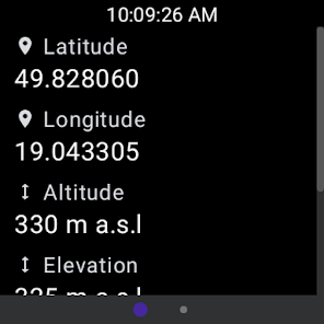
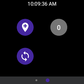
Our app comes with a brand new application for watch devices with Wear OS. You can easily save your current location without using your phone and synchronize data afterwards to enjoy viewing your saved locations on a bigger screen!
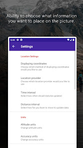
Displays:
1. Latitude and longitude in following formats:
- DMS degrees, minutes and seconds sexagesimal
- DMM degrees and decimal minutes
- DD decimal degrees
- UTM Universal Transverse Mercator
- MGRS Military Grid Reference System
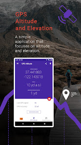
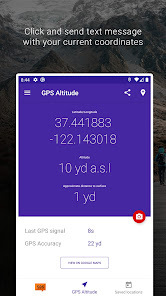
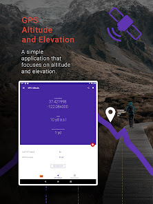
2. Altitude according to your device's satellite GPS receiver
3. Elevation or Height above ground level.
Other features:
- Compatibility with latest Material Design guidelines.
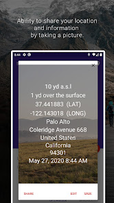
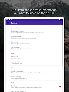
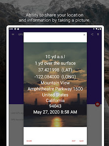
- Ability to share your location and information by taking a picture.
- Ability to choose what information you want to place on the picture.
- Customize photos by changing text color and text position.
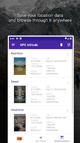
- Save your location data and browse through it anywhere.
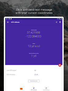
- Click and send text message with your current coordinates.
- Simple tutorial that will help you use the app.
- Use a text message or share on social media or by email, your location information “what is my altitude?” to your friends.
- Copy coordinates to your clipboard.
- Customize how long the application should maintain its location after closing it.
- Export all your saved locations to KML and GPX.
- Export/import all data and images. Easy switch between devices.
- Customize image quality.
Simple explanation of displays:
1. Latitude and longitude in decimal format according to your GPS receiver.
2. Altitude according to your GPS receiver adjusted for sea level. (
Accuracy is up to +-10m)
3. Approximate elevation or height above ground level.
4. Seconds since last GPS satellite signal.
5. Accuracy of GPS satellite signal.
Requires a satellite GPS receiver to function properly. WIFI assisted GPS does not report altitude.
Disclaimer
- GPS does not work well indoors.
- GPS accuracy depends on the receiver in your device
- Data connection is required to get elevation data.
Units include:
- Meter
- Kilometer
- Feet
- Yard
- Mile
- Nautical Mile
Privacy policy: https://hotandroidappsandtools.com/legal/privacy/myaltitude
Terms and conditions: https://hotandroidappsandtools.com/legal/terms/myaltitude
Displays:
1. Latitude and longitude in following formats:
- DMS degrees, minutes and seconds sexagesimal
- DMM degrees and decimal minutes
- DD decimal degrees
- UTM Universal Transverse Mercator
- MGRS Military Grid Reference System
2. Altitude according to your device's satellite GPS receiver
3. Elevation or Height above ground level.
Other features:
- Compatibility with latest Material Design guidelines.
- Ability to share your location and information by taking a picture.
- Ability to choose what information you want to place on the picture.
- Customize photos by changing text color and text position.
- Save your location data and browse through it anywhere.
- Click and send text message with your current coordinates.
- Simple tutorial that will help you use the app.
- Use a text message or share on social media or by email, your location information “what is my altitude?” to your friends.
- Copy coordinates to your clipboard.
- Customize how long the application should maintain its location after closing it.
- Export all your saved locations to KML and GPX.
- Export/import all data and images. Easy switch between devices.
- Customize image quality.
Simple explanation of displays:
1. Latitude and longitude in decimal format according to your GPS receiver.
2. Altitude according to your GPS receiver adjusted for sea level. (
Accuracy is up to +-10m)
3. Approximate elevation or height above ground level.
4. Seconds since last GPS satellite signal.
5. Accuracy of GPS satellite signal.
Requires a satellite GPS receiver to function properly. WIFI assisted GPS does not report altitude.
Disclaimer
- GPS does not work well indoors.
- GPS accuracy depends on the receiver in your device
- Data connection is required to get elevation data.
Units include:
- Meter
- Kilometer
- Feet
- Yard
- Mile
- Nautical Mile
Privacy policy: https://hotandroidappsandtools.com/legal/privacy/myaltitude
Terms and conditions: https://hotandroidappsandtools.com/legal/terms/myaltitude
Updated on
Safety starts with understanding how developers collect and share your data. Data privacy and security practices may vary based on your use, region, and age. The developer provided this information and may update it over time.


Ratings and reviews
4.1
3.76K reviews

C. Michael Lance
- Flag inappropriate
- Show review history
March 30, 2024
What is the difference Between Altitude asl & Elevation asl? Shows about 20 ft difference @ 1,100 ft. (1,111 vs 1,089). 1,100 is very accurate according to USGS topographical map, but why 2 measures above sea level? More accurate than several other apps I have installed.
3 people found this review helpful

Alec Kristi
- Flag inappropriate
- Show review history
May 23, 2023
not accurate (compared with other apps), pummels you with ads. displays multiple ads inside the app, auto-redirecs to random play store install links on open and close. this app should be reported. Responding to developer: this app should not need an internet connection, as all the necessary data is available from GPS satellites. The accuracy issue isn't due to the GPS "sensor", it's due to developer's errors in the code, as other apps on the same device and same locations do not have problems.
81 people found this review helpful
Android Apps & Tools
May 24, 2023
Dear User, we are sorry for the inconvenience. Accuracy depends on the GPS sensor in the device. Internet connection is used fro example to determine current elevation and is also used to improve current readings. It is especially important when using our application inside building. Have a nice day.

Amanda Kenyon
- Flag inappropriate
August 7, 2020
Totally confusing. Elevation is supposed to be distance above sea level but there is nothing in the app that says elevation OR distance above sea level. It just has "altitude" which would normally be defined as the distance above the ground (no matter where the ground is in relation to sea level). There is a separate value in the app called "approximate distance to surface" which is showing up with no data for me.
72 people found this review helpful
Android Apps & Tools
May 23, 2023
We apologize for your bad experience. Could you please update the application. The older version has some issues that we have fixed. If you still face any issues, please contact us at danielross286@gmail.com.
What's new
- updated UI
- added KMZ export and import option
- bug fixes
- added KMZ export and import option
- bug fixes


