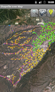
Shapefile over Map
4.0star
110 reviewsinfo
1K+
Downloads

PEGI 3
info


About this app
Load your own shapefiles with this Geographic Information System (GIS) directly from the sdcard of your mobile device and visualize them over a map. You can also edit the values of its dbf table and use it in offline mode, loading maps from your memory card.
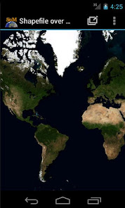
With this GIS application, you can select and load a shp file or load an entire folder automatically.
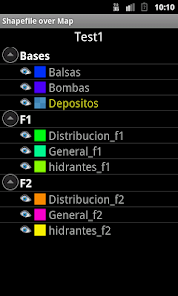
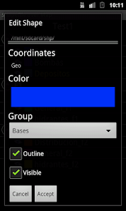
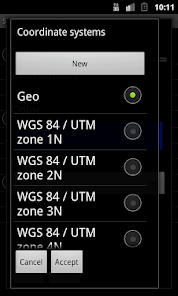
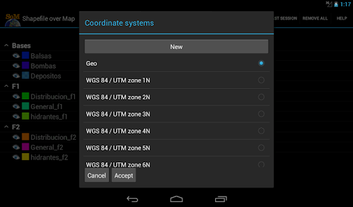
You can select one of these shp files and mark it as the active layer and if you use a long press over one of them you can change its coordinate system, its color or make it invisible.
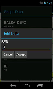
The map will display a series of icons, belonging to each of the records in the active layer, which when pressed will allow you to view and edit information from its corresponding attribute table.
The application also allows you to view your current position via GPS and center the map on it.
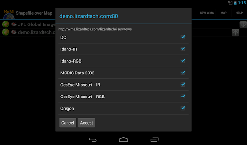
You can choose between several online map servers.
Support for all UTM Projections (WGS84, SAD69 and NAD83)
The .prj file is readed and the coordinate system is automatically assigned.
Now you can save your sessions (a configured shapefile list).
Now also includes a tool to measure distances, areas and perimeters.
New tool to search shapes by dbf field value
New functionality to add and delete dbf fields
New functionality to add WMS servers
A Quick Help has been added
New drawing system. Now move the map is faster
More memory available to load larger shapefiles(only in Android versions 3.0 or later)
New layers administration system
New tool to load the last session
New auto zoom tool to the active layer
New Settings option to change measure units, GPS update time and character codifications
To use a map in offline mode, simply download it previously (for example using Mobile Atlas Creator (using OsmAnd tile storage format)). You must copy the map to the folder you have set on settings and it should be in the format MAPNAME/ZOOM/X/Y.png.tile
With this GIS application, you can select and load a shp file or load an entire folder automatically.
You can select one of these shp files and mark it as the active layer and if you use a long press over one of them you can change its coordinate system, its color or make it invisible.
The map will display a series of icons, belonging to each of the records in the active layer, which when pressed will allow you to view and edit information from its corresponding attribute table.
The application also allows you to view your current position via GPS and center the map on it.
You can choose between several online map servers.
Support for all UTM Projections (WGS84, SAD69 and NAD83)
The .prj file is readed and the coordinate system is automatically assigned.
Now you can save your sessions (a configured shapefile list).
Now also includes a tool to measure distances, areas and perimeters.
New tool to search shapes by dbf field value
New functionality to add and delete dbf fields
New functionality to add WMS servers
A Quick Help has been added
New drawing system. Now move the map is faster
More memory available to load larger shapefiles(only in Android versions 3.0 or later)
New layers administration system
New tool to load the last session
New auto zoom tool to the active layer
New Settings option to change measure units, GPS update time and character codifications
To use a map in offline mode, simply download it previously (for example using Mobile Atlas Creator (using OsmAnd tile storage format)). You must copy the map to the folder you have set on settings and it should be in the format MAPNAME/ZOOM/X/Y.png.tile
Updated on
Data safety
Developers can show information here about how their app collects and uses your data. Learn more about data safety

No information available
Ratings and reviews
3.9
97 reviews

A Google user
- Flag inappropriate
January 27, 2020
Great application, thanks to help my job is very simple
5 people found this review helpful

Luke Penna
- Flag inappropriate
December 8, 2020
App closes every time I try to load a wms service.
3 people found this review helpful
A Google user
- Flag inappropriate
July 5, 2017
Seems very useful for field studies. But trying to add more data keep saying that it can not be loaded or there is not enough room. Any one knows how ro fix this problem? I would be grateful if you help me on that.
6 people found this review helpful