Central America Topo Maps
Contains adsIn-app purchases
4.5star
1.98K reviews
100K+
Downloads

Everyone
info


About this app
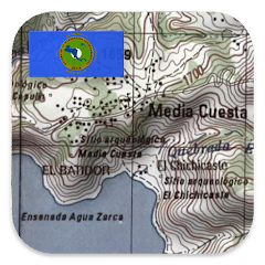
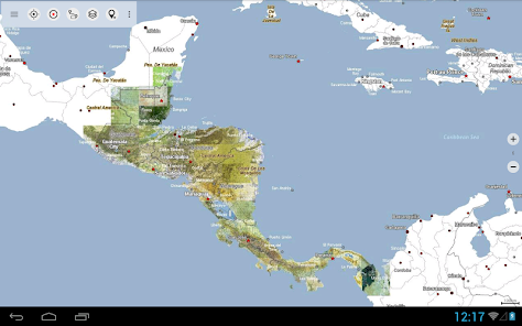
Easy to use outdoor and navigation app with 1:50.000 topographic maps of Guatemala, Honduras, El Salvador and Nicaragua.
This app gives you similar mapping options as you might know from Garmin or Magellan GPS handhelds.
Main features for outdoor-navigation:
• Create and edit Waypoints
• GoTo-Waypoint-Navigation
• Create and edit Routes
• Route-Navigation (Point-to-Point Navigation) (NOT in this free version !)
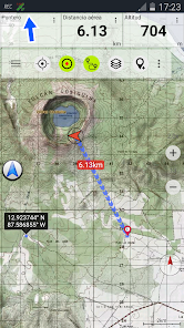
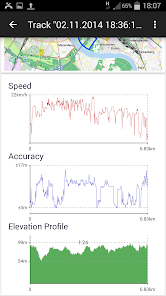
• Track Recording (with speed, elevation and accuracy profile)
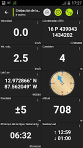
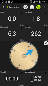
• Tripmaster with fields for odometer, average speed, bearing, elevation, etc.
• GPX-Import / Export, KML-Export (NOT in this free version !)
• Search (placenames, POIs, streets)
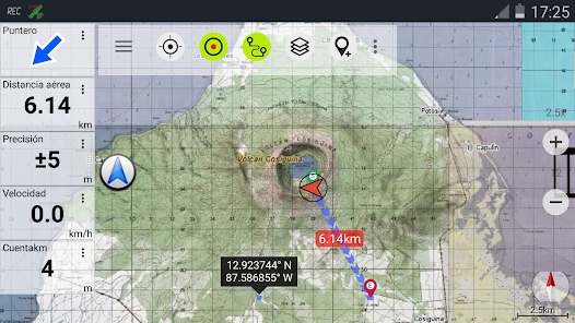
• Customizable datafields in Map View and Tripmaster (e.g. Speed, Distance, Compass, ...)
• Share Waypoints, Tracks or Routes (via eMail, Facebook, ..)
• and many more ...
Available map layers:
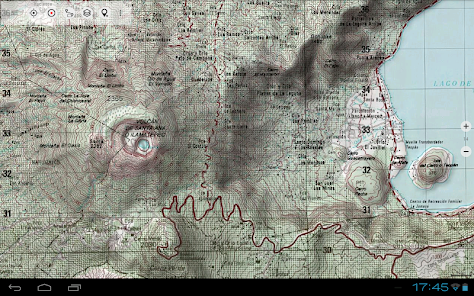
• Topo maps 1:50.000 and 1:250.000 with seamless coverage for Guatemala, Honduras, El Salvador and Nicaragua. Belize, Costa Rica and Panama are covered with 1:250.000 topo maps.
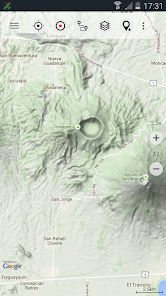
• Google Maps (Satellite images, Road- and Terrain-Map)
• Bing Maps (Satellite images, Road-Map)
• Open Street Maps (OSM Mapnik and Cloudemade Cyclemap)
• Hillshading overlay layer for OSM, Google or Bing maps
LIMITATIONS OF THIS FREE VERSION:
• Ads
• No Bulkdownload of maps for offline usage
• No Hillshading overlay
• Max. 3 Waypoints
• Max. 3 Tracks
• No Routes
• No import of waypoints and tracks
• No Bulkdownload
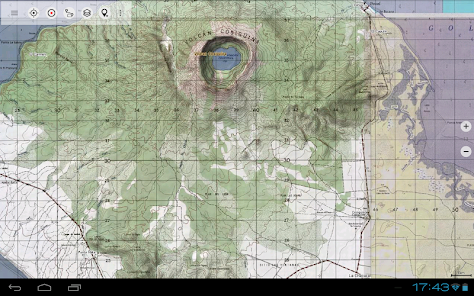
On the 1:50.000 maps you'll find many small roads, pathes and 4WD tracks that are not included in Google, Bing or OpenStreetMaps. The topo maps have a very detailed topography with contour lines. There is no other online mapping service/app available that gives you more detailed geographic features like rivers, lakes, hills, vegetation, villages, etc. for this region.
The topo maps layer is a seamless mosaic of more than 1000 georeferenced maps. Although some of the maps are quite old (production range of the maps is 1955 - 2006) they are still very good for outdoor trips, especially if you are looking adventurous routes or abandoned places. Most maps of Guatemala are quite up to date (mostly created in the 90ies) while maps of eastern Nicaragua were created in the 60ies/79ies. Within the app you can open an overview map with the publishing dates of the maps.
In larger cities you'll find it more usefull to switch to Google or OSM maps but in the backcountry you will recognize the relevance of large scale topographic maps.
The 1:250.000 maps are JOGs (Joint Operations Graphic) which represent a medium scale map intended as both a topographic and an aeronautical chart.
Use this navigation app for outdoor activities like hiking, biking, camping, climbing, riding, canoeing or offroad 4WD tours.
Preload FREE map data for areas without cell service.
The topographic maps are enhanced with Atlogis® hillshading and placenames.
Original publisher of the 1:50.000 topo maps : United States NGA (National Geospatial-Intelligence), NIMA (National Imagery and Mapping Agency), DMA (Defense Mapping Agency)
Original publisher of the 1:250.000 topo maps: US NGA/NIMA JOG (Joint Operations Graphics)
Please send comments and feature requests to camaps@atlogis.com
This app gives you similar mapping options as you might know from Garmin or Magellan GPS handhelds.
Main features for outdoor-navigation:
• Create and edit Waypoints
• GoTo-Waypoint-Navigation
• Create and edit Routes
• Route-Navigation (Point-to-Point Navigation) (NOT in this free version !)
• Track Recording (with speed, elevation and accuracy profile)
• Tripmaster with fields for odometer, average speed, bearing, elevation, etc.
• GPX-Import / Export, KML-Export (NOT in this free version !)
• Search (placenames, POIs, streets)
• Customizable datafields in Map View and Tripmaster (e.g. Speed, Distance, Compass, ...)
• Share Waypoints, Tracks or Routes (via eMail, Facebook, ..)
• and many more ...
Available map layers:
• Topo maps 1:50.000 and 1:250.000 with seamless coverage for Guatemala, Honduras, El Salvador and Nicaragua. Belize, Costa Rica and Panama are covered with 1:250.000 topo maps.
• Google Maps (Satellite images, Road- and Terrain-Map)
• Bing Maps (Satellite images, Road-Map)
• Open Street Maps (OSM Mapnik and Cloudemade Cyclemap)
• Hillshading overlay layer for OSM, Google or Bing maps
LIMITATIONS OF THIS FREE VERSION:
• Ads
• No Bulkdownload of maps for offline usage
• No Hillshading overlay
• Max. 3 Waypoints
• Max. 3 Tracks
• No Routes
• No import of waypoints and tracks
• No Bulkdownload
On the 1:50.000 maps you'll find many small roads, pathes and 4WD tracks that are not included in Google, Bing or OpenStreetMaps. The topo maps have a very detailed topography with contour lines. There is no other online mapping service/app available that gives you more detailed geographic features like rivers, lakes, hills, vegetation, villages, etc. for this region.
The topo maps layer is a seamless mosaic of more than 1000 georeferenced maps. Although some of the maps are quite old (production range of the maps is 1955 - 2006) they are still very good for outdoor trips, especially if you are looking adventurous routes or abandoned places. Most maps of Guatemala are quite up to date (mostly created in the 90ies) while maps of eastern Nicaragua were created in the 60ies/79ies. Within the app you can open an overview map with the publishing dates of the maps.
In larger cities you'll find it more usefull to switch to Google or OSM maps but in the backcountry you will recognize the relevance of large scale topographic maps.
The 1:250.000 maps are JOGs (Joint Operations Graphic) which represent a medium scale map intended as both a topographic and an aeronautical chart.
Use this navigation app for outdoor activities like hiking, biking, camping, climbing, riding, canoeing or offroad 4WD tours.
Preload FREE map data for areas without cell service.
The topographic maps are enhanced with Atlogis® hillshading and placenames.
Original publisher of the 1:50.000 topo maps : United States NGA (National Geospatial-Intelligence), NIMA (National Imagery and Mapping Agency), DMA (Defense Mapping Agency)
Original publisher of the 1:250.000 topo maps: US NGA/NIMA JOG (Joint Operations Graphics)
Please send comments and feature requests to camaps@atlogis.com
Updated on
Safety starts with understanding how developers collect and share your data. Data privacy and security practices may vary based on your use, region, and age. The developer provided this information and may update it over time.

This app may share these data types with third parties
Personal info, App activity and 2 others

No data collected
Learn more about how developers declare collection

Data is encrypted in transit

You can request that data be deleted
Ratings and reviews
4.5
1.92K reviews

Karsten Keese
- Flag inappropriate
- Show review history
January 19, 2022
Central America most definitely includes México, but this software does not. Furthermore, its developers intend to milk customers ad infinitum with recurring subscription fees, not offering any way to purchase the map once and for all. Consequently, it is now being uninstalled.
22 people found this review helpful

Edo Moepe
- Flag inappropriate
April 26, 2023
Very easy to use,the app is very pretty cool,but many adds coming in from phone,.Fixed this
2 people found this review helpful

A Google user
- Flag inappropriate
March 12, 2019
This is good topo app. Many detailed maps from variety of cartographic data providers.
46 people found this review helpful
What's new
・Improvements & Fixes


