Topo GPS
In-app purchases
4.2star
2.26K reviews
100K+
Downloads

Everyone
info


About this app
Makes from your phone or tablet a complete GPS device with detailed topographic maps. Viewed maps will be stored on your device so that Topo GPS can also be used offline.
Why should you buy an expensive GPS device if you can install Topo GPS? Topo GPS contains all functions of a regular GPS device for less money, has a much more detailed map, and is more convenient to operate. The accuracy of the position determination is in favorable conditions about 5 m.
Ideal for walking, hiking, cycling, mountain biking, sailing, horse-riding, geocaching, scouting, trail running and other outdoor activities. Also suited for outdoor professionals.
Map
* To use Topo GPS you need to buy a map.
* Official topographic maps of many countries, including USA, Great Britain (OS Explorer), New Zealand and Australia are available as in-app purchase.
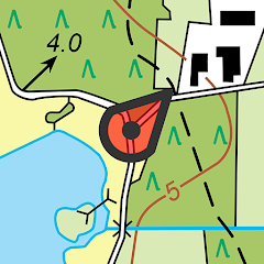
* Topographic maps are very detailed maps, include height contours and are very suited for outdoor activities.
* All maps of a certain region can be made offline accessible using the map download screen.
* Easy switching between maps.
* OpenStreetMap with height contours for worldwide coverage.
* Aerial imagery of a few countries including USA.
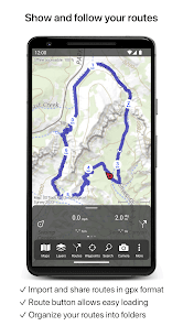
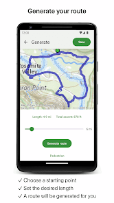
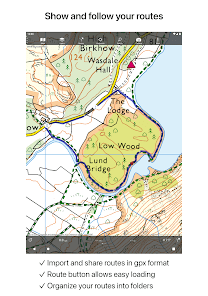
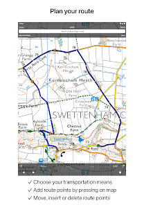
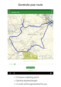
Routes
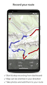
* Recording routes, with pause and restart possibility.
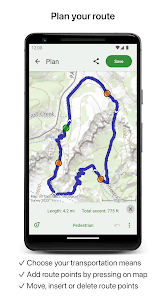
* Planning routes via route points.
* Generating routes
* Editing routes
* Searching routes with filters.
* Routes can be organized into folders.
* Height profiles
* Importing and exporting routes in gpx/kml/kmz format.
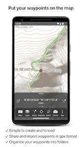
Waypoints
* Easy adding by pressing long on map.
* Adding waypoints through address or coordinates.
* Editing waypoints.
* Importing and exporting waypoints in gpx/kml/kmz/csv/geojson format.
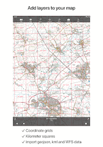
Layers
Layers contain information that can be added to and removed from the map.
* Long distance bicycle routes
* Mountainbike routes
Coordinates
* Easy entering coordinates
* Scanning coordinates
* Supported coordinate systems:
WGS84 decimal, WGS84 degree minutes (seconds), UTM, MGRS, and other country specific coordinate systems.
* Coordinates grid layers
Intuitive interface
* Clear menu with most important functions.
* Different dashboard panels with distance, time, speed, altitude and coordinates.
* Clear manual at www.topo-gps.com
Supported file formats
* gpx, kml/kmz (all also zip compressed), csv
If you are recording a route, the GPS will run in the background. The battery of your device will be emptied faster, when using the GPS in the background.
Rdzl, the company behind Topo GPS, cares very much about your privacy. The Topo GPS app does not have user accounts. We do not obtain in any way the position of the user of Topo GPS. Rdzl does also not obtain any data created or imported by the user, like routes and waypoints. We only obtain a route if it is shared manually by the user with Topo GPS. Ads are not shown in Topo GPS. We sell our product, not our user data.
Privacy policy: https://www.topo-gps.com/privacy-policy
Terms of use: https://www.topo-gps.com/terms-of-use
Why should you buy an expensive GPS device if you can install Topo GPS? Topo GPS contains all functions of a regular GPS device for less money, has a much more detailed map, and is more convenient to operate. The accuracy of the position determination is in favorable conditions about 5 m.
Ideal for walking, hiking, cycling, mountain biking, sailing, horse-riding, geocaching, scouting, trail running and other outdoor activities. Also suited for outdoor professionals.
Map
* To use Topo GPS you need to buy a map.
* Official topographic maps of many countries, including USA, Great Britain (OS Explorer), New Zealand and Australia are available as in-app purchase.
* Topographic maps are very detailed maps, include height contours and are very suited for outdoor activities.
* All maps of a certain region can be made offline accessible using the map download screen.
* Easy switching between maps.
* OpenStreetMap with height contours for worldwide coverage.
* Aerial imagery of a few countries including USA.
Routes
* Recording routes, with pause and restart possibility.
* Planning routes via route points.
* Generating routes
* Editing routes
* Searching routes with filters.
* Routes can be organized into folders.
* Height profiles
* Importing and exporting routes in gpx/kml/kmz format.
Waypoints
* Easy adding by pressing long on map.
* Adding waypoints through address or coordinates.
* Editing waypoints.
* Importing and exporting waypoints in gpx/kml/kmz/csv/geojson format.
Layers
Layers contain information that can be added to and removed from the map.
* Long distance bicycle routes
* Mountainbike routes
Coordinates
* Easy entering coordinates
* Scanning coordinates
* Supported coordinate systems:
WGS84 decimal, WGS84 degree minutes (seconds), UTM, MGRS, and other country specific coordinate systems.
* Coordinates grid layers
Intuitive interface
* Clear menu with most important functions.
* Different dashboard panels with distance, time, speed, altitude and coordinates.
* Clear manual at www.topo-gps.com
Supported file formats
* gpx, kml/kmz (all also zip compressed), csv
If you are recording a route, the GPS will run in the background. The battery of your device will be emptied faster, when using the GPS in the background.
Rdzl, the company behind Topo GPS, cares very much about your privacy. The Topo GPS app does not have user accounts. We do not obtain in any way the position of the user of Topo GPS. Rdzl does also not obtain any data created or imported by the user, like routes and waypoints. We only obtain a route if it is shared manually by the user with Topo GPS. Ads are not shown in Topo GPS. We sell our product, not our user data.
Privacy policy: https://www.topo-gps.com/privacy-policy
Terms of use: https://www.topo-gps.com/terms-of-use
Updated on
Safety starts with understanding how developers collect and share your data. Data privacy and security practices may vary based on your use, region, and age. The developer provided this information and may update it over time.

No data shared with third parties
Learn more about how developers declare sharing

This app may collect these data types
Financial info

Data is encrypted in transit

Data can’t be deleted
Ratings and reviews
4.2
2.09K reviews

Manuel Chirouze
- Flag inappropriate
December 25, 2023
I was a longtime Viewranger fan. Call me cheap but I don't want to pay a subscription service for an app I might use 4 times a year. This app has a very clear design, I spent $10 for great map coverage (perpetual not subscription) and within 15 minutes was out jogging in unknown territory with clear route tracking. Seems to be everything I need. After the hike I wish there were some additional statistics such as total elevation but still worth the 5 star review
7 people found this review helpful

Nick Marchant
- Flag inappropriate
September 2, 2023
Generally very good and my best option as a replacement for Viewranger, but I would prefer the arrow indicating location and direction to be clearer (Viewranger used to have an excellent, very sensitive long arrow showing exact location and direction you were pointing towards). Also some basic info like MPH would be useful, or am I missing something about where that is shown?
11 people found this review helpful

Fiona Sansom
- Flag inappropriate
- Show review history
March 31, 2024
Update: don't know if it was the latest update, but the GPS is working as it should now and recording properly in the background. I have also gone into my setting to make sure the app is never put to sleep to save battery power (permissions all looked fine already). Plotting a route is still a bit clunky, but this is the best hiking tracking app I've used, as an alternative to the old Viewranger discontinued App.
2 people found this review helpful
rdzl
March 27, 2024
Maybe the recent update (8.2.*) solves the issue?
It is also important to allow Topo GPS to use the battery in the background. For this go to the Android settings > Apps > Topo GPS > Battery.


