
PM Navi
500+
Downloads

Rated for 3+
info

About this app
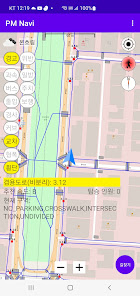
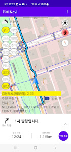
This program uses the SAFE PM terminal's sensor values and location information (RTK GNSS) or GPS to display the PM's current location on the map and SAFE INFO according to the direction of travel.
SAFE INFO is classified into warnings to PM riders about speeding, bus stops, entrances (entrances and exits), ramps (downhills), curves, intersections, narrow areas, and crosswalks, as well as information about one-way streets, parking, and pedestrian road violations.
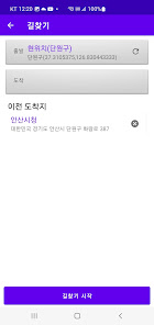
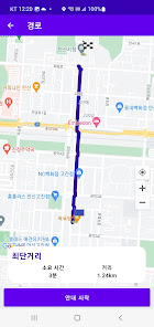
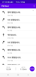
The PM searches the route to the destination using available roads and provides route guidance to the user.
This program is only available in some areas of Ansan (test bad).
SAFE INFO is classified into warnings to PM riders about speeding, bus stops, entrances (entrances and exits), ramps (downhills), curves, intersections, narrow areas, and crosswalks, as well as information about one-way streets, parking, and pedestrian road violations.
The PM searches the route to the destination using available roads and provides route guidance to the user.
This program is only available in some areas of Ansan (test bad).
Updated on
Safety starts with understanding how developers collect and share your data. Data privacy and security practices may vary based on your use, region, and age. The developer provided this information and may update it over time.

No data shared with third parties
Learn more about how developers declare sharing

No data collected
Learn more about how developers declare collection
What's new
- 내비게이션 기능 추가. 길찾기 버튼 이용. 테스트 배드 주변만 사용가능.
App support
phone
Phone number
+82221093900