Gps Offline Map For Hiking
Contains ads
100+
Downloads

Everyone
info
About this app
This app allows you to check your current location on the map by saving maps in advance even in places where radio waves do not reach.
You can reduce the risk of getting lost by climbing or hiking. You can also save the track logs as a gpx file.
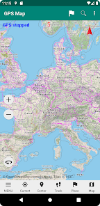
■ You can check your current location on the map
Simply tap the "Current Location" button at the bottom of the screen to display the red mark of your current location on the map. Since the GPS function of the terminal is used,
GPS function must be turned on. You can also save the location information of your current location as a registered location with the touch of a button.
The use of location information is the following functions only within this app.
(1) Display your current location on a map.
(2) Track log recording.
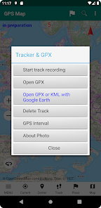
■ Track log (walking track, hereafter log) can be saved
With the background function, this app can log even if you are using other apps. When saving is completed,
Save it in the app as GPX file.
* Note: Even if you quit the app, it is still recorded in the background, so start the app again and start it again.
Continue recording until you are finished.
■ Maps can be displayed even outside the service area
If you save the map in advance, you can display the map even if you are out of service or offline. You can save
Only the map of the Geographical Survey Institute. There is no limit to the range that can be saved at one time.
.
■ Can display GPX files
You can read the GPX file downloaded and display the track on the map.
You can check your current location while walking. You can reduce the risk of getting lost by climbing or hiking.
■ You can register the position
You can register the position you want to remember and display it on the map. You can register up to 1000 locations.
■ You can measure the distance
If you select distance measurement from the menu, you can measure the distance just by tapping on the screen.
.
■ Precautions for use
If you use it for mountain climbing, please bring a map, compass and spare battery just in case.
In addition, this author is not responsible for any loss or damage such as distress caused by using this application.
■ Inquiries
Service: https://gacool.jp
Email: gacoolmap@gmail.com
by susumu hirao
You can reduce the risk of getting lost by climbing or hiking. You can also save the track logs as a gpx file.
■ You can check your current location on the map
Simply tap the "Current Location" button at the bottom of the screen to display the red mark of your current location on the map. Since the GPS function of the terminal is used,
GPS function must be turned on. You can also save the location information of your current location as a registered location with the touch of a button.
The use of location information is the following functions only within this app.
(1) Display your current location on a map.
(2) Track log recording.
■ Track log (walking track, hereafter log) can be saved
With the background function, this app can log even if you are using other apps. When saving is completed,
Save it in the app as GPX file.
* Note: Even if you quit the app, it is still recorded in the background, so start the app again and start it again.
Continue recording until you are finished.
■ Maps can be displayed even outside the service area
If you save the map in advance, you can display the map even if you are out of service or offline. You can save
Only the map of the Geographical Survey Institute. There is no limit to the range that can be saved at one time.
.
■ Can display GPX files
You can read the GPX file downloaded and display the track on the map.
You can check your current location while walking. You can reduce the risk of getting lost by climbing or hiking.
■ You can register the position
You can register the position you want to remember and display it on the map. You can register up to 1000 locations.
■ You can measure the distance
If you select distance measurement from the menu, you can measure the distance just by tapping on the screen.
.
■ Precautions for use
If you use it for mountain climbing, please bring a map, compass and spare battery just in case.
In addition, this author is not responsible for any loss or damage such as distress caused by using this application.
■ Inquiries
Service: https://gacool.jp
Email: gacoolmap@gmail.com
by susumu hirao
Updated on
Safety starts with understanding how developers collect and share your data. Data privacy and security practices may vary based on your use, region, and age. The developer provided this information and may update it over time.

No data shared with third parties
Learn more about how developers declare sharing

This app may collect these data types
Location, App activity and 2 others

Data is encrypted in transit

Data can’t be deleted
What's new
The map is now in English.