
Rando en Sud Vienne Poitou
4.2star
6 reviewsinfo
1K+
Downloads

PEGI 3
info
About this app
Visit Destination Sud Vienne Poitou with the “Destination Nature en SVP” mobile application or on our online portal “rando.sudviennepoitou.com”, with its hiking and horseback riding routes, bicycle tours, trail routes and activities nautical.
The application allows you to discover all the nature activities and heritage of the territory of Sud Vienne Poitou.
Exceptional territory where outdoor activities, nautical activities and thrills meet in the middle of a remarkable cultural heritage, with its Abbey of Saint-Savin labeled UNESCO World Heritage and its cycle route crossed by the Eurovélo 3 .
Destination Sud Vienne Poitou combines activities for young and old, this territory is a real return to nature where life is good. Its gastronomic richness with its local producers, makes it an exceptional place to share, where we can finally meet again.
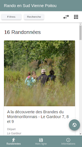
The app offers detailed, illustrated and regularly updated routes.
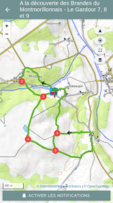
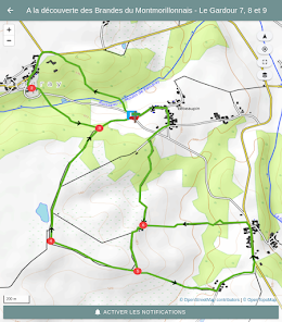
Many functionalities are available: 3D navigation, GPS tracks, a hike-sheet printing service and a system for the hike manager.
This territory is a real gem to discover.
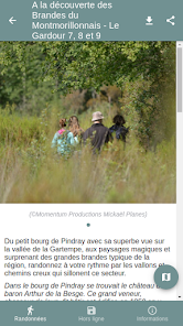
The app is your mobile assistant in the field. It allows you to be informed about the characteristics of your practice, to discover the heritage and points of interest near your hike.
For ease of use, the app can be used in "offline" mode, downloading routes in advance from your smartphone or tablet and using your device's GPS for successful navigation.
For your next hike, set off with your guide in your pocket, do not hesitate ... "Destination Nature in SVP" with Geotrek Sud Vienne Poitou.
The rando.sudviennepoitou.com site will guide you on the trails of South Vienne Poitou around Montmorillon, Lathus-Saint-Rémy and many other adventures ...
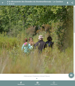
It allows you to view and download the files for hiking, horseback riding, mountain biking, day cycling or gentle roaming with their points of interest and photos.
Innovative and functional, the -free- application will help you to:
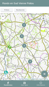
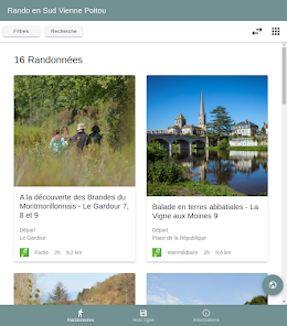
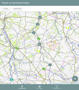
- Select your hikes according to your criteria (duration, height difference, theme, etc.) or using the interactive map of the territory.
- Carry detailed sheets and maps by downloading them one by one with wifi or 4G / 5G to consult them in the mountains without connection.
- Navigate the field with the GPS of your smartphone or tablet
- Be alerted to the heritage near the trail via the GPS
- Know the tourist services near the routes (accommodation, ideas for stays, etc.)
See you soon on the trails. So don't wait any longer, go exploring!
The application allows you to discover all the nature activities and heritage of the territory of Sud Vienne Poitou.
Exceptional territory where outdoor activities, nautical activities and thrills meet in the middle of a remarkable cultural heritage, with its Abbey of Saint-Savin labeled UNESCO World Heritage and its cycle route crossed by the Eurovélo 3 .
Destination Sud Vienne Poitou combines activities for young and old, this territory is a real return to nature where life is good. Its gastronomic richness with its local producers, makes it an exceptional place to share, where we can finally meet again.
The app offers detailed, illustrated and regularly updated routes.
Many functionalities are available: 3D navigation, GPS tracks, a hike-sheet printing service and a system for the hike manager.
This territory is a real gem to discover.
The app is your mobile assistant in the field. It allows you to be informed about the characteristics of your practice, to discover the heritage and points of interest near your hike.
For ease of use, the app can be used in "offline" mode, downloading routes in advance from your smartphone or tablet and using your device's GPS for successful navigation.
For your next hike, set off with your guide in your pocket, do not hesitate ... "Destination Nature in SVP" with Geotrek Sud Vienne Poitou.
The rando.sudviennepoitou.com site will guide you on the trails of South Vienne Poitou around Montmorillon, Lathus-Saint-Rémy and many other adventures ...
It allows you to view and download the files for hiking, horseback riding, mountain biking, day cycling or gentle roaming with their points of interest and photos.
Innovative and functional, the -free- application will help you to:
- Select your hikes according to your criteria (duration, height difference, theme, etc.) or using the interactive map of the territory.
- Carry detailed sheets and maps by downloading them one by one with wifi or 4G / 5G to consult them in the mountains without connection.
- Navigate the field with the GPS of your smartphone or tablet
- Be alerted to the heritage near the trail via the GPS
- Know the tourist services near the routes (accommodation, ideas for stays, etc.)
See you soon on the trails. So don't wait any longer, go exploring!
Updated on
Safety starts with understanding how developers collect and share your data. Data privacy and security practices may vary based on your use, region, and age. The developer provided this information and may update it over time.

No data shared with third parties
Learn more about how developers declare sharing

No data collected
Learn more about how developers declare collection
Ratings and reviews
4.2
6 reviews
What's new
Amélioration de la performance
Amélioration de l'ergonomie
Correction de bogues
Amélioration de l'ergonomie
Correction de bogues


