Light pollution map

4.6star
46 reviews
1K+
Downloads

PEGI 3
info


About this app
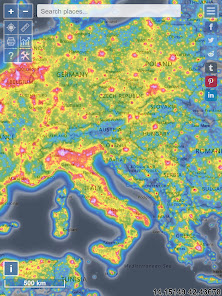
A light pollution map to help you find the best locations for observing or to buy that perfect piece of land you always wanted for stargazing or just to satisfy your curiosity.
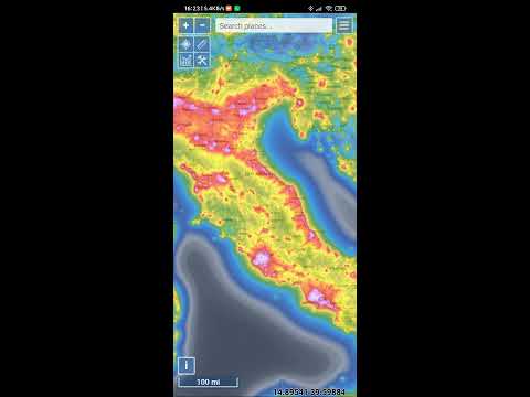
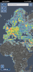
It started out as a web application you might have heard about at www.lightpollutionmap.info, but now it's also available as a mobile application. It displays VIIRS/DMSP/World Atlas/Aurora overlays, IAU observatories and the user measurements features over Microsoft Bing base maps (road and hybrid Bing). It is a port of www.lightpollutionmap.info, so it has practically the same functions, but features an offline mode and no advertisements.
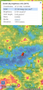
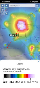
The primary use is to show VIIRS/DMSP data in a friendly manner, but over time it also included some other interesting overlays that concern light pollution like SQM/SQC, World Atlas 2015 zenith brightness, clouds, aurora and IAU observatories. If you have a permanent SQM reader installed you can add it to the map by sending me an e-mail.
If you want an analysis of radiance (VIIRS/DMSP) changes over a period of time, then please use the Lighttrends application (look under Help).
Please send comments and requests for new features via email (look below for developer contact)
Functionalities:
- VIIRS, Sky Brightness, Cloud coverage and Aurora forecast layers
- VIIRS and Sky Brightness layers can be displayed also in color blind friendly colors
- Road & Satellite base maps
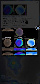
- Cloud animation for the last 12 hours
- Get detail radiance and SQM values from layers at a click. For World Atlas 2015, you also get Bortle class estimation.
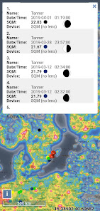
- SQM, SQM-L, SQC, SQM-LE, SQM readings submitted by users
- Submit your own SQM (L) reading
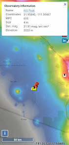
- Observatories layer
- Save your favorite locations
- Distance measurement tool with azimuth angle report
- Offline mode (Sky brightness map and a base map are saved to your device, so it will be displayed when you are offline)
Permissions:
- Location (to show you your location)
- Network state (used whether to display online or offline maps)
- Read & write to external storage (used to save offline maps)
It started out as a web application you might have heard about at www.lightpollutionmap.info, but now it's also available as a mobile application. It displays VIIRS/DMSP/World Atlas/Aurora overlays, IAU observatories and the user measurements features over Microsoft Bing base maps (road and hybrid Bing). It is a port of www.lightpollutionmap.info, so it has practically the same functions, but features an offline mode and no advertisements.
The primary use is to show VIIRS/DMSP data in a friendly manner, but over time it also included some other interesting overlays that concern light pollution like SQM/SQC, World Atlas 2015 zenith brightness, clouds, aurora and IAU observatories. If you have a permanent SQM reader installed you can add it to the map by sending me an e-mail.
If you want an analysis of radiance (VIIRS/DMSP) changes over a period of time, then please use the Lighttrends application (look under Help).
Please send comments and requests for new features via email (look below for developer contact)
Functionalities:
- VIIRS, Sky Brightness, Cloud coverage and Aurora forecast layers
- VIIRS and Sky Brightness layers can be displayed also in color blind friendly colors
- Road & Satellite base maps
- Cloud animation for the last 12 hours
- Get detail radiance and SQM values from layers at a click. For World Atlas 2015, you also get Bortle class estimation.
- SQM, SQM-L, SQC, SQM-LE, SQM readings submitted by users
- Submit your own SQM (L) reading
- Observatories layer
- Save your favorite locations
- Distance measurement tool with azimuth angle report
- Offline mode (Sky brightness map and a base map are saved to your device, so it will be displayed when you are offline)
Permissions:
- Location (to show you your location)
- Network state (used whether to display online or offline maps)
- Read & write to external storage (used to save offline maps)
Updated on
Safety starts with understanding how developers collect and share your data. Data privacy and security practices may vary based on your use, region, and age. The developer provided this information and may update it over time.

No data shared with third parties
Learn more about how developers declare sharing

No data collected
Learn more about how developers declare collection
Ratings and reviews
4.5
43 reviews

Nivesh Varma
- Flag inappropriate
September 15, 2020
Need to allow choosing SD card or other location for offline cache download. Also adding locations to favorites list ("My Locations") just doesn't work. Nothing happens when you try to type the name, or hit the pin button, or anything. Also can't even see the entire map legend, the legend image is too long to fit on the the screen and it's not possible to scroll down to see the rest of it.
8 people found this review helpful
Deneb, Jurij Stare, s.p.
May 10, 2021
Thanks for your valuable feedback!
All mentioned issues had been since fixed, reworked or newly implemented.

Talha Zia
- Flag inappropriate
- Show review history
May 23, 2021
Best app about light pollution. I have been using the web based version since 2017 and so far its the most accurate since I have been to various darksky sites after using it. Is it possible to extract data in csv format from it? Also I can't seem to click on Circle tool for drawing roi why?
13 people found this review helpful
Deneb, Jurij Stare, s.p.
May 23, 2021
The data is stored as raster (as this is the most efficient way), but can be converted to any format. Contact me over email and I'm sure we'll find a solution.

Roland Stalder
- Flag inappropriate
June 11, 2022
Great App! All the important light pollution data in one map with numerous, very useful overlay controls.👏 Thanks for including all my SQM data from Unihedron as well 🙌
2 people found this review helpful
What's new
- Fixed SQM-LE chart not displaying