Pacific NW National Forest
3.0star
57 reviews
10K+
Downloads

Everyone
info
About this app
Explore this app to find all the recreation opportunities the Pacific Northwest Region's 17 U.S. Forest Service Forests has to offer. Find hiking trails, campgrounds, picnicking areas, swimming holes, and more! This app's mapping capabilities make it easy to find outdoor recreation opportunities near you or explore new ones off the beaten path. The app is packed with useful information about trail and road condition, local weather conditions, fire information, and so much more.
National Forests in the Pacific Northwest received over 15 million visits each year. This mobile app allows those visitors to easily discover recreational opportunities near them. Whether you're looking for information about a favorite hiking trail, searching for a new camping area, or looking for a great spot to see wildflowers or wildlife, turn your phone into an official recreation guide with the Pacific Northwest Forests app. Here are some ways of using this app to ensure you're taking advantage of all the great tools and information available:
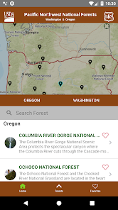
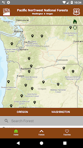
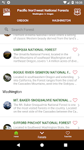
EXPLORE
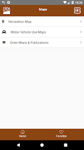
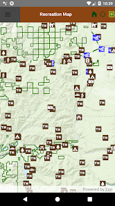
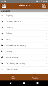
Search for hiking, camping, picnicking, skiing, snowshoeing, cross country skiing, hunting, horse riding, climbing, mountain biking, road biking,scenic driving, and OHV/ATV areas using our interactive mapping tools or by looking through lists of all the recreation opportunities on each forest. Zoom in on maps and easily navigate to find information about any of our thousands of great recreation sites. Then get driving directions to the trail or campground.
BE PREPARED
Find out about current road and trail conditions before you go, so you can be prepared to have a great experience in your U.S. Forest Service lands. All 17 forests highlighted in the app provide detailed information about road access and trail access. The app also provides updates on closure areas so you'll have the best information about recreation availability across the entire Pacific Northwest U.S. Forest Service system.
BE SAFE
Hiking and camping season are also fire season in the Pacific Northwest. Ensure the safety of yourself and your family by checking in with the app while making travel plans to visit your public lands. Current fire information is conveniently included in the app so you'll have the most up-to-date information about where fires are burning and what you need to know and do to be safe.
HAVE FUN!
Your Pacific Northwest Forests are some of the most beautiful places on Earth. They include breath-taking waterfalls, powerful rivers, deep and lush woods, spectacular vistas, expansive lakes, grand mountain peaks, and vast grasslands.
The 17 Forests highlighted in the Pacific Northwest Forests app include:
-Colville National Forest
-Columbia River Gorge National Scenic Area
-Deschutes National Forest
-Fremont-Winema National Forest
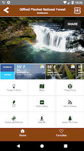
-Gifford Pinchot National Forest
-Malheur National Forest
-Mt. Baker-Snoqualmie National Forest
-Mt. Hood National Forest
-Ochoco National Forest and Crooked River National Grassland
-Okanogan-Wenatchee National Forest
-Olympic National Forest
-Rogue River-Siskiyou National Forest
-Siuslaw National Forest
-Umatilla National Forest
-Umpqua National Forest
-Wallowa-Whitman National Forest
-Willamette National Forest
ENJOY
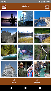
Your U.S. Forest Service lands are here for you to enjoy. Check out our forest photo galleries included in this app to be inspired to explore new areas of the Pacific Northwest and discover the beauty and grandeur of the mountains, streams, skies and forests of your Pacific Northwest Forests!
National Forests in the Pacific Northwest received over 15 million visits each year. This mobile app allows those visitors to easily discover recreational opportunities near them. Whether you're looking for information about a favorite hiking trail, searching for a new camping area, or looking for a great spot to see wildflowers or wildlife, turn your phone into an official recreation guide with the Pacific Northwest Forests app. Here are some ways of using this app to ensure you're taking advantage of all the great tools and information available:
EXPLORE
Search for hiking, camping, picnicking, skiing, snowshoeing, cross country skiing, hunting, horse riding, climbing, mountain biking, road biking,scenic driving, and OHV/ATV areas using our interactive mapping tools or by looking through lists of all the recreation opportunities on each forest. Zoom in on maps and easily navigate to find information about any of our thousands of great recreation sites. Then get driving directions to the trail or campground.
BE PREPARED
Find out about current road and trail conditions before you go, so you can be prepared to have a great experience in your U.S. Forest Service lands. All 17 forests highlighted in the app provide detailed information about road access and trail access. The app also provides updates on closure areas so you'll have the best information about recreation availability across the entire Pacific Northwest U.S. Forest Service system.
BE SAFE
Hiking and camping season are also fire season in the Pacific Northwest. Ensure the safety of yourself and your family by checking in with the app while making travel plans to visit your public lands. Current fire information is conveniently included in the app so you'll have the most up-to-date information about where fires are burning and what you need to know and do to be safe.
HAVE FUN!
Your Pacific Northwest Forests are some of the most beautiful places on Earth. They include breath-taking waterfalls, powerful rivers, deep and lush woods, spectacular vistas, expansive lakes, grand mountain peaks, and vast grasslands.
The 17 Forests highlighted in the Pacific Northwest Forests app include:
-Colville National Forest
-Columbia River Gorge National Scenic Area
-Deschutes National Forest
-Fremont-Winema National Forest
-Gifford Pinchot National Forest
-Malheur National Forest
-Mt. Baker-Snoqualmie National Forest
-Mt. Hood National Forest
-Ochoco National Forest and Crooked River National Grassland
-Okanogan-Wenatchee National Forest
-Olympic National Forest
-Rogue River-Siskiyou National Forest
-Siuslaw National Forest
-Umatilla National Forest
-Umpqua National Forest
-Wallowa-Whitman National Forest
-Willamette National Forest
ENJOY
Your U.S. Forest Service lands are here for you to enjoy. Check out our forest photo galleries included in this app to be inspired to explore new areas of the Pacific Northwest and discover the beauty and grandeur of the mountains, streams, skies and forests of your Pacific Northwest Forests!
Updated on
Safety starts with understanding how developers collect and share your data. Data privacy and security practices may vary based on your use, region, and age. The developer provided this information and may update it over time.

No data shared with third parties
Learn more about how developers declare sharing

No data collected
Learn more about how developers declare collection
Ratings and reviews
3.0
56 reviews

A Google user
- Flag inappropriate
April 6, 2019
It needs to include interactive maps of trails, OHV & FS routes, waypoints & landmarks, campsites, hunting land boundaries, etc. (you know, things actually useful to someone exploring the parks). This app doesn't do anything not already available on a smartphone. And it directs user to the internet or a Ranger Station for maps. It's basically a digital advertising pamphlet for the PacNW parks.
25 people found this review helpful

William Kemper
- Flag inappropriate
April 9, 2024
Works much better and easier to use than USFS visitor app (likely because it's much smaller). Missing lots of campgrounds on the maps feature. I'll be using this app. Hopefully they will create more like this for other areas.

Allen Miller
- Flag inappropriate
June 21, 2022
Terrible! Not mobile friendly at all. The important information is so small it can't be read and the other stuff literally takes half the page. The map is jumpy and doesn't easily enlarge without changing locations. Anyone who have ever used Google maps, Bing maps, even Apple does better than this app.
6 people found this review helpful
What's new
-Adds support for Android API 33 as per Google Play requirements.


