
Altimeter
Contains adsIn-app purchases
4.5star
17.2K reviews
1M+
Downloads

Everyone
info

About this app
Altimeter is an handy Android application allowing you to get the true altitude above sea level (MSL) at your current location or any location on earth. It requires access to your device location to get raw altitude from the GPS signal and do not require a network connection to work. True altitude above mean sea level is determined using EGM96 Earth Gravitational Model. Main features are :
• Offline true altitude above sea level
• No network required (works offline and in flight mode)
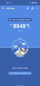
• True altitude above sea level (AMSL using EGM96)
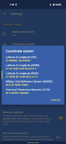
• Ordnance Survey National Grid reference system (OSGB36)
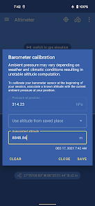
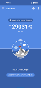
• Use Barometer or GPS Satellite
• Address at current location
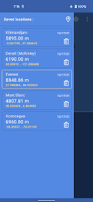
• Save altitude at location
• Altitude accuracy estimation
• Horizontal accuracy estimation
• Altitude at any location
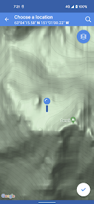
• Pick location on a Map
• Open photo geotags to display associated altitude
• Search for a location by name or address
• Universal Transverse Mercator coordinates (UTM)
• Military Grid Reference System coordinates (MGRS)
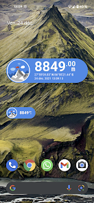
• Home screen widget to display altitude at current position
Network access is required to get the altitude of a location picked from the map.
Height above mean sea level (AMSL) is the elevation (on the ground) or altitude (in the air) of an object, relative to the average sea level datum. Normal GPS elevation considers the entire Earth as an ellispoid and differences up to 100 metres (328 feet) can exist between this ellipsoid height and true mean tidal height. The alternative, which is what we use in this application, is a geoid-based vertical datum such as the global EGM96 model.
Altitude vertical accuracy is defined at 68% confidence. Specifically, as 1-side of the 2-sided range above and below the estimated altitude reported, within which there is a 68% probability of finding the true altitude.
Enjoy!
• Offline true altitude above sea level
• No network required (works offline and in flight mode)
• True altitude above sea level (AMSL using EGM96)
• Ordnance Survey National Grid reference system (OSGB36)
• Use Barometer or GPS Satellite
• Address at current location
• Save altitude at location
• Altitude accuracy estimation
• Horizontal accuracy estimation
• Altitude at any location
• Pick location on a Map
• Open photo geotags to display associated altitude
• Search for a location by name or address
• Universal Transverse Mercator coordinates (UTM)
• Military Grid Reference System coordinates (MGRS)
• Home screen widget to display altitude at current position
Network access is required to get the altitude of a location picked from the map.
Height above mean sea level (AMSL) is the elevation (on the ground) or altitude (in the air) of an object, relative to the average sea level datum. Normal GPS elevation considers the entire Earth as an ellispoid and differences up to 100 metres (328 feet) can exist between this ellipsoid height and true mean tidal height. The alternative, which is what we use in this application, is a geoid-based vertical datum such as the global EGM96 model.
Altitude vertical accuracy is defined at 68% confidence. Specifically, as 1-side of the 2-sided range above and below the estimated altitude reported, within which there is a 68% probability of finding the true altitude.
Enjoy!
Updated on
Safety starts with understanding how developers collect and share your data. Data privacy and security practices may vary based on your use, region, and age. The developer provided this information and may update it over time.

No data shared with third parties
Learn more about how developers declare sharing

This app may collect these data types
Location, App info and performance, and Device or other IDs

Data is encrypted in transit

Data can’t be deleted
Ratings and reviews
4.5
16.9K reviews

Emily Z
- Flag inappropriate
February 28, 2024
They lie in the Play Store when they say they don't share your data with third parties - this app sends your data to at least 127 different companies (per the enormous list in the app). They do give you the option to opt out of consent, but then there's a sneaky extra layer where they have another set of "legitimate interest" tracking for all of those companies, and you have to uncheck each company individually. Disgusting.
47 people found this review helpful

Timothy Robbins
- Flag inappropriate
- Show review history
January 6, 2024
Stay away from this app! This has got to be the most egregious app, and there are many very nasty apps out there, for being nothing more than a tracking device. If you don't just click the box when setting up the app, but actually look at what you're agreeing to, you will be disgusted. They give a button to agree to everything but you will have to manually disable, I guessing around 100 trackers. There ara far better altimeters out there anyways.
55 people found this review helpful

PiroChu
- Flag inappropriate
- Show review history
March 5, 2023
This app is clean and simple in doing what it is intended to do, without additional extra junky features to clutter. The 2x1 widget also looks great, though it doesn't seem to update as frequently as every 328ft (100m) per Settings. *Wishlist: (a) display altimeter in both feet & meter together, or have a quick toggle switch right on main app page instead of under Settings; (b) a smaller altimeter view that can be overlaid (Picture-in-picture) while running Maps/Waze.
129 people found this review helpful


