
Weserbergland – Urlaubsplaner
Contains ads
10K+
Downloads

Everyone
info
About this app
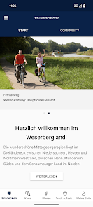
Let yourself be guided through the Weserbergland in an interactive and multimedia way. The Weserbergland app bundles all important tourist information for the region Weserbergland, which you need for your vacation planning and on-site during your vacation.
Included in the app are:
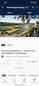
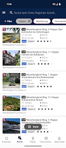
- Bicycle tours: signposted regional cycling day tours and the Radfernweg Weser cycle path
- Hiking tours: regional circular hiking trails for day hikes, as well as the quality hiking trails Weserbergland-Weg and Ith-Hils-Weg
- Historical city tours and interesting sights along the tours for all cities and historical sites belonging to the project "Historic Weserbergland"
- Excursion destinations and attractions: Numerous destinations, service companies and the like are included in the app
- Accommodation tips: Numerous hosts from the Weserbergland are presented in the app, a booking can be made directly to the host.
- Camping & motorhome places in the Weserbergland: Over 50 large and small places throughout the Weserbergland are waiting for you! We have gathered equipment information for all seats so that you can easily find the right place with the help of the app.
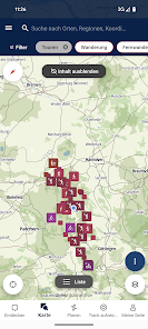
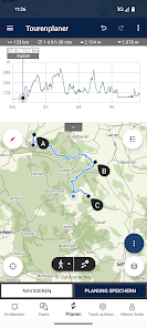
Also included is an interactive map with tour planner for free scheduled tours and tour planning to the included attractions, so you can also individually plan your itineraries in Weserbergland.
Tour data can be stored offline, so that they remain usable even in the case of bad or no mobile reception.
This is how it works:
This app guides you individually through cities and sites, hiking and cycling trails. Simply start at any station and experience or experience the tour at your own pace. The GPS navigation function of your smartphone makes it easier for you to find your way around and shows you where you are on the tour.
The tour can be stopped or continued at any station and so you can also pause on the go at your leisure.
Would you prefer to put together your own route in the Weserbergland? No problem: The zoomable, topographic maps of our service provider Outdooractive will help you with this. With just a few clicks you can plan your own individual routes.
A fast mobile internet connection (at least 3G) is recommended! Depending on the provider and the amount of data, this can trigger corresponding costs. We therefore recommend using the app in the online version only with mobile data flatrate. If network coverage is weak or high mobile data costs are to be avoided on the way: Save the appropriate tour / map data using a WLAN / hotspot connection before a tour and then use the corresponding data offline.
Using the app in the background with activated GPS reception can drastically shorten the battery life.
Provider of data in the app:
Weserbergland Tourism e.V.
Mailbox 100339
31753 Hamelin
Fon 05151 / 9300-0
info@weserbergland-tourismus.de
www.weserbergland-tourismus.de
Technical implementation:
Outdooractive GmbH & Co. KG
Missener Straße 18
87509 Immenstadt
Germany
Tel .: +49 8323 8006-0
Fax: +49 8323 8006-190
E-Mail: info@outdooractive.com
Included in the app are:
- Bicycle tours: signposted regional cycling day tours and the Radfernweg Weser cycle path
- Hiking tours: regional circular hiking trails for day hikes, as well as the quality hiking trails Weserbergland-Weg and Ith-Hils-Weg
- Historical city tours and interesting sights along the tours for all cities and historical sites belonging to the project "Historic Weserbergland"
- Excursion destinations and attractions: Numerous destinations, service companies and the like are included in the app
- Accommodation tips: Numerous hosts from the Weserbergland are presented in the app, a booking can be made directly to the host.
- Camping & motorhome places in the Weserbergland: Over 50 large and small places throughout the Weserbergland are waiting for you! We have gathered equipment information for all seats so that you can easily find the right place with the help of the app.
Also included is an interactive map with tour planner for free scheduled tours and tour planning to the included attractions, so you can also individually plan your itineraries in Weserbergland.
Tour data can be stored offline, so that they remain usable even in the case of bad or no mobile reception.
This is how it works:
This app guides you individually through cities and sites, hiking and cycling trails. Simply start at any station and experience or experience the tour at your own pace. The GPS navigation function of your smartphone makes it easier for you to find your way around and shows you where you are on the tour.
The tour can be stopped or continued at any station and so you can also pause on the go at your leisure.
Would you prefer to put together your own route in the Weserbergland? No problem: The zoomable, topographic maps of our service provider Outdooractive will help you with this. With just a few clicks you can plan your own individual routes.
A fast mobile internet connection (at least 3G) is recommended! Depending on the provider and the amount of data, this can trigger corresponding costs. We therefore recommend using the app in the online version only with mobile data flatrate. If network coverage is weak or high mobile data costs are to be avoided on the way: Save the appropriate tour / map data using a WLAN / hotspot connection before a tour and then use the corresponding data offline.
Using the app in the background with activated GPS reception can drastically shorten the battery life.
Provider of data in the app:
Weserbergland Tourism e.V.
Mailbox 100339
31753 Hamelin
Fon 05151 / 9300-0
info@weserbergland-tourismus.de
www.weserbergland-tourismus.de
Technical implementation:
Outdooractive GmbH & Co. KG
Missener Straße 18
87509 Immenstadt
Germany
Tel .: +49 8323 8006-0
Fax: +49 8323 8006-190
E-Mail: info@outdooractive.com
Updated on
Safety starts with understanding how developers collect and share your data. Data privacy and security practices may vary based on your use, region, and age. The developer provided this information and may update it over time.


What's new
Mit dem Update wurde die Menüstruktur der App angepasst und übersichtlicher gestaltet. Außerdem wurden in dieser Version Fehler behoben und Verbesserungen vorgenommen, um das Benutzererlebnis optimal auf Ihre Wünsche und den neusten Stand der Technik anzupassen.


