
Gammertingen
100+
Downloads

Everyone
info

About this app
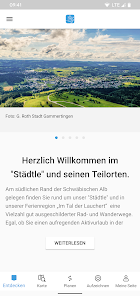
The interactive guide for the "Städtle" - as Gammertingen is affectionately called by the locals. Our Laucherttal town is located in the northern tip of the Sigmaringen district and not at all behind the moon, but somewhat hidden on the southern edge of the Swabian Jura. With its attractive landscape with the winding Lauchert/Fehlatal, the beautiful plateaus of the Swabian Alb, the extensive forests and the healthy bracing climate, it is an ideal starting point for various leisure activities such as cycling or hiking.
Whether alone, in a group or with the family, you will find a wide range of activities around Gammertingen.
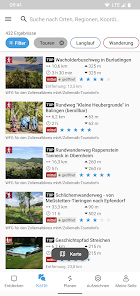
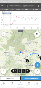
This guide offers GPS tracks of our city history tours, hikes, bike tours, cross-country ski trails and more - including detailed descriptions.
Our tours all have detailed information such as:
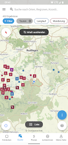
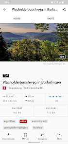
- Outdoor map
- Key facts (length, altitude difference, duration, difficulty)
- Detailed description including pictures
- Tour course in the map
- Elevation profile
- Sights (churches, monuments, buildings)
- Refreshments and accommodation options
- Excursion destinations in the vicinity
Have fun in Gammertingen
Whether alone, in a group or with the family, you will find a wide range of activities around Gammertingen.
This guide offers GPS tracks of our city history tours, hikes, bike tours, cross-country ski trails and more - including detailed descriptions.
Our tours all have detailed information such as:
- Outdoor map
- Key facts (length, altitude difference, duration, difficulty)
- Detailed description including pictures
- Tour course in the map
- Elevation profile
- Sights (churches, monuments, buildings)
- Refreshments and accommodation options
- Excursion destinations in the vicinity
Have fun in Gammertingen
Updated on
Safety starts with understanding how developers collect and share your data. Data privacy and security practices may vary based on your use, region, and age. The developer provided this information and may update it over time.


What's new
Fehlerkorrekturen


